The Colonel
Member
yea...this is gross. Hopefully let's just chalk it up to the happy hour run

Follow along with the video below to see how to install our site as a web app on your home screen.
Note: This feature may not be available in some browsers.
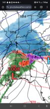
Yes that's probably heavy snow north of thereNAM says gross... juiced temps at 850, but you can kind of see what I am assuming is rapid cooling/deform band setting up in C ALView attachment 32749
Can someone explain what a “deformation band” is?Yes that's probably heavy snow north of there
A deformation band is basically a heavy snow band that sets up and doesn't progress much. It's also where you can get thundersnow and higher snowfall rates leading to greater snowfall totals than currently forecast.Can someone explain what a “deformation band” is?
Despite some of the models coming in with more ice, it appears the NWS and weather channel have gotten more aggressive with the snowfall here in Forsyth county ga.
Thanks!A deformation band is basically a heavy snow band that sets up and doesn't progress much. It's also where you can get thundersnow and higher snowfall rates leading to greater snowfall totals than currently forecast.

You're welcome! No problemThanks!
Watching right now. The ensemble model he showed has plummeted. Then he showed the NWS model and pointed out that it is way more aggressive. Then he sounded like he thought they may change it later on. I'd be getting worried about a bust if I was in Bham.I just heard James Spann's afternoon update. He's pretty Scroogish on ALs I--20 area snow forecast.
Wouldn't this still start as snow, but just change to ice instead of a cold rain by afternoon?You can literally see the wedge causing the rain to turn to ice...the bend of the isobars is the wedge high building in....with the low to the southwest, air is basically pulled in, very shallow cold dry air.
Yes I believe it will start as snow before we see warming aloft. At some point around midday, though the warmer air is likely to overtake the meltative cooling, especially if precip is lighter. The flakes will melt into rain and then fall into the shallow dry cold air flowing from the east and freeze giving is freezing rain.Wouldn't this still start as snow, but just change to ice instead of a cold rain by afternoon?
I would definitely take 2 inches...especially living in south central Alabama...we always get left out, accept for those rare storms when North Alabama stays completely dry.NWS HUN backing off a tad.....
"Given the antecedent ground conditions/cold air,
snowfall accumulations are expected to develop, especially north
of the TN River. However, a 55-60kt low level jet out of the SSW
is also expected to develop during the day Fri, which may limit
the potential for higher snowfall amounts.
Nevertheless, snowfall accumulations around 2-5 inches look to
fall thru Fri evening, with the higher amounts again north of the
TN River. If temps climb just above freezing during the day Fri, a
mixture of rain/snow is possible especially south of the TN River.
This may also result in a brief mixture of rain/sleet into Fri
evening, as the upper trough pattern moves into the Mid South/TN
Valley areas. Regardless of the wintry mix, hazardous driving
conditions are expected to develop, especially during the day Fri."