
If it cools the whole column, it could. If you get good cold air damming where you are borderline between ZR and SN, you can get all snow instead. Typically it doesn't cool to height though - WAA overcomes it with the warm nose at height, so you get warm moist air at height and precip falling into dry air that cools either enough to turn it to sleet or just cools the surface temp enough to turn the rain to ice at the surface.Oh, I was hoping it meant more snow.....
Navigation
Install the app
How to install the app on iOS
Follow along with the video below to see how to install our site as a web app on your home screen.
Note: This feature may not be available in some browsers.
More options
-
Welcome to TalkWeather! We see you lurking around TalkWeather! Take the extra step and join us today to view attachments, see less ads and maybe even join the discussion. CLICK TO JOIN TALKWEATHER
You are using an out of date browser. It may not display this or other websites correctly.
You should upgrade or use an alternative browser.
You should upgrade or use an alternative browser.
Winter threat: 1/9-12/ 25
- Thread starter DetectiveWX
- Start date
Surprisingly both Jackson and Memphis are saying the same thing for winter weather. Significant: Heavy snow and/or sleet accumulation will result in widespread travel disruptions. I've never seen both offices totally on board with winter weather before
Attachments
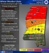
Was expecting "slight chance of cold rain" from MEG.Surprisingly both Jackson and Memphis are saying the same thing for winter weather. Significant: Heavy snow and/or sleet accumulation will result in widespread travel disruptions. I've never seen both offices totally on board with winter weather before
Or freezing rain. Having the cold air already in place is making a big difference in messaging. Like the only big question is the placement and track of the Gulf lowWas expecting "slight chance of cold rain" from MEG.
Thanksgivingbrown
Member
From WAFF in HSV
Gail
Member
That is shocking!Surprisingly both Jackson and Memphis are saying the same thing for winter weather. Significant: Heavy snow and/or sleet accumulation will result in widespread travel disruptions. I've never seen both offices totally on board with winter weather before
Gail
Member
This is what CAFB meteorologists are currently saying…
“
Good Morning,
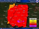
There are no major changes on the winter weather for Friday at this point in time. It continues to appear that the Hwy 82 corridor will be the transition zone between freezing rain, sleet, and snow, with mostly rain south of Lowndes county. Precipitation will begin tomorrow night as rain or a mix of rain and snow. Early Friday morning there could very well be some freezing rain (ice) early in the morning (4-8am) before transitioning into a mix of ice pellets and snow mid morning before going to all snow by Friday afternoon, before ending early Friday evening. At this time snowfall totals look like 1-3 inches in northern Lowndes county, closer to 1 inch south of 82 in Lowndes county. Some ice and sleet accumulation for Friday morning look to be .10 to .25 inches are possible for the entire county. We’ll continue to provide updates through event.”
“
Good Morning,
There are no major changes on the winter weather for Friday at this point in time. It continues to appear that the Hwy 82 corridor will be the transition zone between freezing rain, sleet, and snow, with mostly rain south of Lowndes county. Precipitation will begin tomorrow night as rain or a mix of rain and snow. Early Friday morning there could very well be some freezing rain (ice) early in the morning (4-8am) before transitioning into a mix of ice pellets and snow mid morning before going to all snow by Friday afternoon, before ending early Friday evening. At this time snowfall totals look like 1-3 inches in northern Lowndes county, closer to 1 inch south of 82 in Lowndes county. Some ice and sleet accumulation for Friday morning look to be .10 to .25 inches are possible for the entire county. We’ll continue to provide updates through event.”

Thanksgivingbrown
Member
HUN AFD mentions widespread 4-7 inches with 8in possible in higher elevations in northeast Alabama. Also includes a “high end scenario (90th
percentile) showing 7-10 inches with higher amounts up to 12".
percentile) showing 7-10 inches with higher amounts up to 12".
HRRR at max at 48

Putting down a swath of very solid amounts upstream. Up to a foot in far SW AR.

Putting down a swath of very solid amounts upstream. Up to a foot in far SW AR.
Temp at Brownsville, TX has been stuck at 46 all morning with a 37 degree dewpoint, a howling NNW wind and high pressure. Lots of gradient between land and gulf to work with for cyclogenesis.
- Admin
- #272
- Messages
- 2,433
- Reaction score
- 2,273
- Location
- Meridianville, Al
- Special Affiliations
- SKYWARN® Volunteer
WAFF going with the NAM, looks like.
View attachment 32708
Hmm. I thought Brad normally went with the RAP in these situations. I could easily be wrong.
If he is, he's being more conservative than the RAP is, for sure.Hmm. I thought Brad normally went with the RAP in these situations. I could easily be wrong.

Real time analysis will be big moving forward if there's any trends for colder or warmer.Temp at Brownsville, TX has been stuck at 46 all morning with a 37 degree dewpoint, a howling NNW wind and high pressure. Lots of gradient between land and gulf to work with for cyclogenesis.
- Admin
- #275
- Messages
- 2,433
- Reaction score
- 2,273
- Location
- Meridianville, Al
- Special Affiliations
- SKYWARN® Volunteer
Like I said, I'm probably wrong. Not the first time. Today.

I feel for broadcast mets on this one, I really do. A high impact event for their viewers, with little clarity to be had. I'd just be honest with viewers and say this one could go a lot of different ways. The more definitive the forecast, the further out on a potentially icy limb, IMO.
My biggest fear is that the nam is underestimating the shallow cold air from the east and this winds up being a crippling ice storm east of I65 and along and south of I20 around 30 miles.I feel for broadcast mets on this one, I really do. A high impact event for their viewers, with little clarity to be had. I'd just be honest with viewers and say this one could go a lot of different ways. The more definitive the forecast, the further out on a potentially icy limb, IMO.
brianc33710
Member
OK on the TV stations it appears Cen AL has snow until 5 a, a wintery/wintry mix until 12 p & after 5 p & maybe rain from 12-5 p. But the hi is 33-4 & I've seen snow at 33.
Yes you can have snow at 33 but only if the entire column above is 32 or lower..we won't have that, there will be a layer of around 40° air aloft that the snow flakes will melt in while passing through before reaching the groundOK on the TV stations it appears Cen AL has snow until 5 a, a wintery/wintry mix until 12 p & after 5 p & maybe rain from 12-5 p. But the hi is 33-4 & I've seen snow at 33.
What makes this even more complicated is that melting is a cooling process, so if there are enough snow flakes melting in that layer, it can chill it....but jeep in mind there is contanst flow of warm air in that layer above. Also near the ground, freezing is a warming process...so if rain is freezing on contact, it releases latent heat that could cause the temp to go above freezing....then it melts....which is a cooling process....and the reverse happens. Lots going on at onceYes you can have snow at 33 but only if the entire column above is 32 or lower..we won't have that, there will be a layer of around 40° air aloft that the snow flakes will melt in while passing through before reaching the ground
Ice storms are delicate balance of cooling and warming. Heavy rain freezing on contact can release quite amount of heat..is that offset by cold air flowing in? Very complicated.