Tomcats Forever!
Member
Temperature got up to 102 today, setting a new daily record. Hottest day in Louisville in 12 years.
And just a month and a half later, our first graupel of the season.
Follow along with the video below to see how to install our site as a web app on your home screen.
Note: This feature may not be available in some browsers.
Temperature got up to 102 today, setting a new daily record. Hottest day in Louisville in 12 years.
Crazy, ain't it? Here in the upstate mountains of SC it was mid- 80's several days ago and dipped down to the mid-30'd last night, all in the course of one week. Even more fun (sarcasm here) is winds are gusting to about 40 right now on my hilltop and there's things I need to do outside including more clean-up of the 'presents' Helene gave meAnd just a month and a half later, our first graupel of the season.


I'm not used to seeing cloudy weather and almost wildfire smoke-like haze with a high pressure system. I never noticed such a thing back East. Went out today, and while there is a little wind now and then, the air does make your eyes sting, and I noticed streaks on the bus windows -- had to clean my glasses, too!
It has been cold, and people use their fireplaces/wood stoves, plus there's I-5 not too far away and all that Thanksgiving traffic.
We've got a subsidence inversion, per Portland NWS. They've lifted the air stagnation advisory here (west central Willamette Valley) but it's in effect in parts of Oregon and Washington still.
") Not that we get much winter here and that's just the way I like it
Not that we get much winter here and that's just the way I like it 
I'm not used to seeing cloudy weather and almost wildfire smoke-like haze with a high pressure system. I never noticed such a thing back East. Went out today, and while there is a little wind now and then, the air does make your eyes sting, and I noticed streaks on the bus windows -- had to clean my glasses, too!
It has been cold, and people use their fireplaces/wood stoves, plus there's I-5 not too far away and all that Thanksgiving traffic.
We've got a subsidence inversion, per Portland NWS. They've lifted the air stagnation advisory here (west central Willamette Valley) but it's in effect in parts of Oregon and Washington still.
 so it was a surprise to me.
")
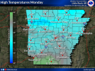
Lord. Insert facepalmHave y’all noticed NWS offices using weird color scale for forecast high graphics? I noticed one from FFC the other day and now this one from Little Rock, AR. 50s should not be blue, LOL.

The most important quantity for meteorologists is of course the product of latent pressure and temperostrophic enthalpy, though 'how nice the weather is' is a close second.