• Welcome to TalkWeather!
    We see you lurking around TalkWeather! Take the extra step and join us today to view attachments, see less ads and maybe even join the discussion.
    CLICK TO JOIN TALKWEATHER

Volcano thread

USGS made it the topic of this week's Volcano Watch. The whole post is interesting, but here's an excerpt:

The current increases in the number of earthquakes (particularly in the upper East Rift Zone) and rates of ground inflation are showing us that Kīlauea’s magma storage system is becoming primed for its next event. One potential outcome could be another significant intrusion—when magma moves into a new area within the volcano but fails to erupt on the surface—such as what occurred along the Southwest Rift Zone during late January/early February of this year. Another potential outcome could be another eruption, either inside or outside the caldera.
 
Mount Ibu is one of the many Indonesian volcanoes that erupts almost constantly with a low intensity. This time, though, it put a little more muscle into it than usual: :cool:

[FPMKI on X: "G. Ibu Teramati 2 kali letusan dengan tinggi 200-5000 m dan warna asap putih, kelabu, dan hitam. ● Teramati lontaran lava pijar diarah barat laut dan barat daya jarak lontaran 1.5 km dari pusat erupsi (pada erupsi pukul 09:12 WIT. https://t.co/5UtKsXLqAO" /

Twitter translation: "Mt. Ibu Observed 2 eruptions with a height of 200-5000 m and smoke colors of white, gray and black.● Observed ejection of incandescent lava in the northwest and southwest direction, distance 1.5 km from the eruption center (during the eruption at 09:12 WIT."
 
There are killer floods and landslides going on in parts of Indonesia -- just wanted to share this because the phrase "cold lava" seems popular in English-language online coverage that I have seen.

"Cold lava" is a rock, as one volcanologist I follow pointed out yesterday.

"Lahar" is an Indonesian word that Google translates as "cold lava" but that Indonesians and geoscientists use for an ash-water flooding event -- it can be the consistency of wet concrete but the particles drop out fairly quickly.

It can also be quite hot, if it has passed over fresh deposits.

This 2010 lahar at Merapi appears to be cool in temperature but sometimes they are steaming:


Here is one at a Colombian volcano in 2008; the video is in Spanish but it's worth a look because some geologists compare it to what Mount Rainier might do in its next collapse event. It occurred at night; the video at around 1:30 shows its peak. This was not an Armero-type tragedy -- they foresaw it and evacuated communities downstream.


Getting back to Indonesia, I believe "banjir" is a word for "flood," and a "banjir lahar" is a lahar with relatively low particle content that can still pack a wallop:


[FPMKI on X: "Korban meninggal dunia akibat Banjir Lahar dingin dan tanah longsor yang menerjang sejumlah daerah di Sumatra Barat tercatat 58 orang, sementara korban hilang bertambah dari 27 menjadi 35 orang dalam pencarian. https://t.co/HeupNR8FNR" /

Twitter translation: "The death toll from cold lava floods and landslides that hit a number of areas in West Sumatra was recorded as 58 people, while the number of missing victims increased from 27 to 35 people during the search."

That's just one island. I have read about tens of casualties in South Sulawesi, too.

The country has lots of volcanic ash lying around and recently experienced wildfires on volcano slopes. It's a lethal mix during the rainy season.

I wish journalists would use "lahar," though -- that's the term volcanologists use in outreach and it would help the public comprehend hazards better. Nobody except machine translators says "cold lava."
 
They've raised Mount Ibu to Level IV, which triggers evacuations, but I can't find much more info yet.

[INFOMITIGASI on X: "Terjadi erupsi G. Ibu pada hari Kamis, 16 Mei 2024, pukul 09:58 WIT. Tinggi kolom letusan teramati ± 5000 m di atas puncak (± 6325 m di atas permukaan laut). Kolom abu teramati berwarna kelabu dengan intensitas tebal ke arah utara dan timur laut. https://t.co/sOLcfMgCTP" /

This is the current image on the official app, but the tweet info might be old. The app update is in Indonesian and there's a translation problem again, but per the current VONA, plume height exceeds 20,000 feet.

Here's some Australian news from a few hours ago.
 
"Mother" -- the meaning of Indonesian "Ibu" -- had a big one last night, per Reuters. It's hard to find video, but necessary because of the language barrier. There is this:


Here's a background post I did on it in 2022. As mentioned, Mount Ibu erupts a lot but at a lower intensity most of the time.
 
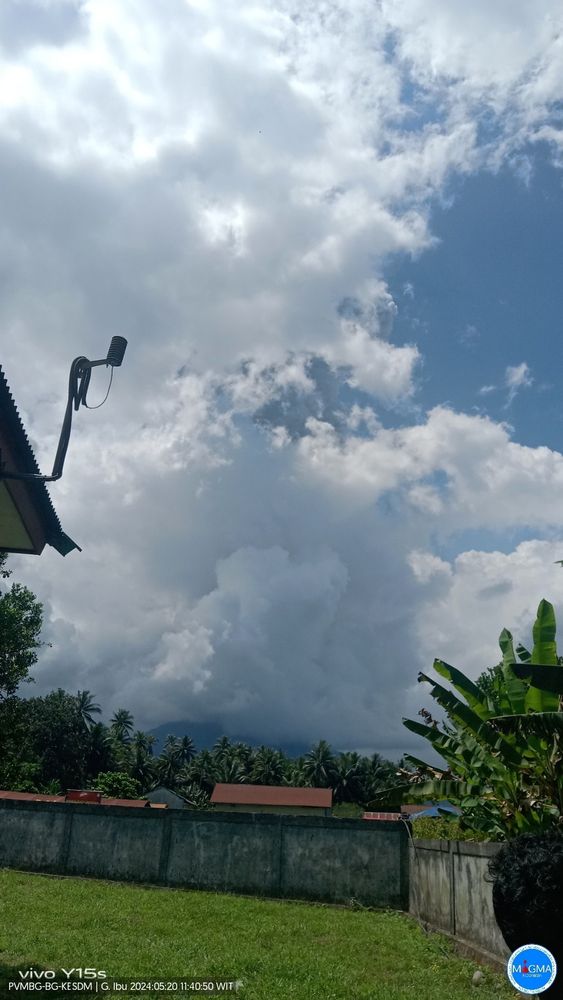
Ibu is not done yet. Per this Blue Sky post via Google Translate (see photo):

Mount Ibu eruption on Monday, May 20 2024, at 11:36 WIT. The height of the eruption column was observed to be ± 5000 m above the peak (± 6325 m above sea level). The ash column was observed to be gray with thick intensity towards the southwest and west.

 
Sheesh -- both of the Hawaiian volcano stars have such short runs these days!

No updates yet...
 
I post a lot about active volcanoes but little about those nearby -- they're sound asleep and just snore a little. But today Eric Klemetti is posting about the ones in Oregon and next he will look at the California Cascades and future activity.

Of the ones he mentioned today, Jefferson is right across the valley from us here on the Cascade Range foothills but haze often conceals it.

Over in Albany, out in the valley, on clear days you can juuuust make out Mount Hood some 70 miles to the north from an intersection near Walmart, and in winter snow on the black basalt makes the nearby crater field around Jefferson look indeed like another planet.

I still haven't been able to get a picture of the Three Sisters though they do pop into view from high ground here sometimes on clear days. Even then, though, they're about a hundred miles southeast and it's hard to distinguish between their ice fields and orographic clouds

Mount St. Helens is visible, surprisingly close, as you head into Portland on the interstate. I just went up to the city a few times shortly after moving out here to check it out but did enjoy seeing MSH.

People are shocked when I tell them I hope to see Mount St. Helens erupt because they don't realize that it has erupted in the 21st century, too -- great fun it was to watch that harmless event online from the other side of the country!

The Forest Service had a cam on the MSH crater but didn't realize it had a bit of night capability. All of us enthusiasts yelling "GLOW! WE'VE GOT GLOW TONIGHT!" The public enthusiasm for Volcano Cam during that 2004-2007 eruption, I read later, helped spur the rise of public volcano cams there and elsewhere (where possible, that is -- many Cascades volcanoes are located inconveniently for such coverage).

It got me interested in following volcanoes, as did Dr. Klemetti's blogging about them. And it's the most active Cascades volcano and therefore the one I'm most likely to catch live.

But you never know...
 
Well, bombaceous Mount St. Helens or else a Hawaiian-style curtain of fire in Idaho.
 
 
There's nothing newsworthy or immediately world shaking about this video of new activity at one of Mount Etna's summit craters that INGV shared five days ago.

It just shows what really appears to be deep enthusiasm or even love for Etna that I've often noticed while studying up for the eBook or following volcanologists on social media. To some of them, this is a special mountain, it seems.

And Etna is unique in many ways, of course. (An old excerpt from the chapter to show why.)

Also, this is an *excellent* volcano video, showing up-close views that tourists never get to see. Love the head gear.

 
Four people reportedly (autotranslated) have died on Mount Fuji -- and they weren't climbing together, either.

Per various Google-translated X posts from people I've been following since the New Year's Day Noto quake, the man who died on the flank at the eighth station was under forty but knew he had heart disease and enjoyed climbing so much that he carried on anyway.

Not the worst way to go, thinks this healthy but mortality-aware 71-year-old.

Three other people were found in the summit crater, and apparently they all had climbed up there separately (public paths and facilities are not open yet).

No word on the cause of those deaths -- it might have been weather, since conditions are so bad that they could only retrieve one body.

But Fuji-san is slowly -- VERY slowly (multiple links to more info in this blog post) -- waking up again and some magma is probably moving a bit at depth.

I haven't read of any geochemical changes noted yet, but carbon dioxide exsolves from deep magma (they watch for SO2 because it comes out of solution closer to the surface), and lethal levels of CO2 conceivably could have accumulated at the bottom of the crater.

They will have to get everybody down and conduct tests, as well as check instruments up there or install new ones, but it surely is an important question to answer before tourist season: is gas accumulating up there?
 
HAWAIIAN VOLCANO OBSERVATORY STATUS REPORT
U.S. Geological Survey
Sunday, June 30, 2024, 1:43 AM HST (Sunday, June 30, 2024, 11:43 UTC)


KILAUEA
(VNUM #332010)
19°25'16" N 155°17'13" W, Summit Elevation 4091 ft (1247 m)
Current Volcano Alert Level: ADVISORY
Current Aviation Color Code: YELLOW


Activity Summary: Kīlauea's upper East Rift Zone, beneath Chain of Craters Road within Hawaiʻi Volcanoes National Park, has been experiencing a seismic swarm that began in the afternoon of June 27. Late in the evening of June 29, the intensity of seismicity escalated, with earthquake rates reaching approximately 30 events per hour. Most of the earthquakes are centered in the region between Puhimau Crater and the Hilina Pali Road intersection at depths of 1.5–3 km (1–1.8 mi), but they also extend north toward Keanakākoʻi Crater and south to Pauahi Crater. The largest earthquake in the swarm has been a magnitude-3.0 that occurred at 1:03 a.m. HST just north of Hiʻiaka crater at a depth of 3 km (2 mi). Although the summit region has been inflating since the end of the June 3, 2024, eruption southwest of the summit, there have been no significant changes in ground deformation associated with this escalation of seismicity.

Analysis: Following the eruption on June 3, 2024, magma has been repressurizing the storage system beneath Halemaʻumaʻu and the south caldera region, activating earthquakes in the upper East Rift Zone and in the caldera south of Halemaʻumaʻu. At this time, it is not possible to say whether this increase in activity will lead to an intrusion or an eruption in the near future, or simply continue as seismic unrest at depth. Previous eruptions and intrusions beneath the upper East Rift Zone have occurred in the vicinity of Pauahi Crater and Hiʻiaka Crater to the southeast and around Luamanu and Keanakākoʻi Craters at the margin of the caldera. This region erupted several times during the 1960s–1970s; the most recent eruption took place over a single day in November 1979 within and near to Pauahi Crater.
Currently, there is no indication that magma is moving towards the June 3, 2024, eruption site southwest of the caldera. However, changes in the character and location of unrest can occur quickly, as can the potential for eruption.

Updates:  The USGS Hawaiian Volcano Observatory (HVO) will continue to provide daily updates for Kīlauea volcano. Should volcanic activity change significantly, a Volcanic Activity Notice will be issued.

For more information about the meaning of volcano alert levels and aviation color codes, see https://www.usgs.gov/programs/VHP/volcanic-alert-levels-characterize-conditions-us-volcanoes.


More Information:

---

This unofficial but knowledgeable YouTube channel is helpful, too:


Since Kilauea, technically, is on Mauna Loa's flank -- although an independent volcano -- both magmatic systems have some interactions in terms of pressurization and stress, so HVERI (and sometimes the USGS) occasionally will discuss both at the same time.

Right now Mauna Loa is just doing its own thing, recharging slowly after 2022.
 
From today's update:

HAWAIIAN VOLCANO OBSERVATORY DAILY UPDATE
U.S. Geological Survey
Tuesday, July 2, 2024, 7:35 AM HST (Tuesday, July 2, 2024, 17:35 UTC)


KILAUEA
(VNUM #332010)
19°25'16" N 155°17'13" W, Summit Elevation 4091 ft (1247 m)
Current Volcano Alert Level: ADVISORY
Current Aviation Color Code: YELLOW


Activity Summary:  Kīlauea volcano is not erupting. The upper East Rift Zone seismic swarm that began on June 27 abated yesterday morning, though earthquake counts remain above background levels, similar to before the swarm. Longer-term, gradual inflation of the summit and upper rift zones has persisted since the end of the June 3, 2024 eruption. Any substantial increases in seismicity and/or deformation could result in a new eruptive episode, but there are no signs of an imminent eruption at this time...
 
Also,

 
Back
Top