• Welcome to TalkWeather!
    We see you lurking around TalkWeather! Take the extra step and join us today to view attachments, see less ads and maybe even join the discussion.
    CLICK TO JOIN TALKWEATHER

Volcano thread

I found a 2018 IMO post on Katla's last eruption (in 1918) that mentions the monitoring (Klaustur is another name for the settlement of Kirkjubaejarklaustur mentioned in one of the earlier linked news stories on today's jokulhlaup).

This link will get you to all sorts of interesting information, from Magnus Tumi et al., on volcanic hazards in Iceland.
 
Last edited:

VONA message​


Katla​


Time: 27. Jul 2024, 15:54 GMT

Color code: Yellow

Volcano id: 372030


Activity summary:
In the early hours of today, 27 July 2024, increased seismic tremor and earthquake activity begin within the Katla caldera. Presently, a glacial outburst flood is occurring from the eastern side of Mýrdalsjökull - the ice-cap overlying the Katla volcano. The cause of the flood is long-term geothermal activity beneath Mýrdalsjökull. As a precaution, we have temporarily increased the aviation colour-code to take into account the heightened possibility of volcanic unrest. Outburst floods from Mýrdalsjökull often occur during the summer months, especially July. However, the ongoing flood is larger than usual, hence in the increased response.


Cloud height:
N/A


Other cloud information:
N/A


Remarks:
N/A

-----

They have posted an update, too (autotranslated). There are evacuations.
 
RUV live coverage (autotranslated).

Per the drone video, the Ring Road bridge will need repairs, at the very least.

Also, Grimsvotn, under Vatnajokull glacier to the east of Katla and its glacier is notorious for erupting after a subglacial lake drainage takes weight off the caldera floor.

I don't know if this is a whole lake, or if Katla behaves the same way. RUV currently quotes Benedikt:

...

Benedikt Ófeigsson.
Benedikt Ófeigsson, Head of Deformation Measurements at the Icelandic Meteorological Office.RÚV

Volcanic eruption not likely cause​

Benedikt does not think it likely that the run was caused by a volcanic eruption in Mýrdalsjökull.

"We don't think it's an eruption. Anyway, that's not our interpretation, but there have been different opinions about it," he says. "But there are no signs of an eruption going on right now," says Benedikt.

It's hard to tell when it will really start to slow down.

"It takes time to reduce it, but it seems to be starting now," he says.

There is still a rush coming from under the glacier and it depends on how much water will break through...
 
Last edited:
Looks like this might settle down more or less smoothly, though road and bridge repairs are definitely needed.

It's still early but per IMO's new update via GT:

Running from Mýrdalsjökull. The race has reached its peak at Highway 1​


There is nothing in the data to suggest that the run is the result of a volcanic eruption under the glacier​


27.7.2024


Updated July 27 at 21:00


  • The flow in Skálm has decreased
  • The race has reached its peak at the highway
  • The race in Skálm is comparable to the race in Múlakvísl 2011 and likewise the race that was in Múlakvísl in 1955
  • It may take several days for the flow in Skálm to return to normal for the time of year.
  • There is nothing in the data that suggests that a volcanic eruption caused the run in Skálm


Measurements show that the flow in Skálm has significantly decreased. The gauge is located on the bridge over Skálm by highway 1, and therefore the flow from Mýrdalsjökull has reached its peak there. According to the very first estimate, it is believed that the magnitude of the flow was around 1,000 m 3 /s at the main road.


There are no signs that runoff has reached Múlakvísl or other rivers from Mýrdalsjökull.


The unrest that began to be felt at around 11 this morning, so we can only expect that the flow in Skálm will gradually decrease. It may take several days for the flow in Skálm to return to normal for the time of year.


The Norwegian Meteorological Agency continues to monitor the area and closely monitor unrest and seismic activity under the glacier. It can take up to 24 hours for the activity to return to what is known as "normal background activity", so this scenario can be declared over.


Volcanic eruption not the cause of the glacier run today​


There are no signs in the Norwegian Meteorological Agency's data that a volcanic eruption caused the glacier run that occurred today. Although it was an unusually large run, the run is due to geothermal heat in the glacier's cauldrons, meltwater accumulates, which later runs ahead of the glacier. A GPS meter located on Austmannsbunga shows clear signs that the changes measured in the caldera are a regular glacier run. However, it is unclear what causes more water to be released than is generally the case from such runs.


The Coast Guard went on a patrol flight with scientists from the Meteorological Office and the University of Iceland this afternoon to investigate the situation. During that flight, it was confirmed that runoff only came from Sandfellsjökull and from there reached the course of the river Skálm. There was no visibility over Mýrdalsjökull to confirm which boilers the running water came from.

In other news, there were reportedly many tourists in the area around Katla but a police spokesman was not aware of any injuries.

Just reading, I realized that Katla has never erupted during the monitoring era -- scientists interpret historical documents as well as the geologic records of past events, and watch it VERY closely.

There have been large outburst floods a couple times since 1918 without eruption, though, so apparently Katla doesn't have the sort of hair-trigger plumbing that makes Grimsvotn such a rip. Hope so, anyway. ;)
 
It is well on the way to being over, per the IMO (autotranslated), and Katla's status is lowered to green again. As shown on the Reykjanes Peninsula, Icelanders do not respond passively when a volcano messes up their highways -- the Ring Road opened last night, though it's reportedly a single lane across this damaged section.
 
Reportedly (autotranslated), there likely is a magma intrusion in the "mood ring" of volcanoes -- Kelimutu, in Indonesia, so called because its three crater lakes change color.

Here's what they looked like in 2016:


The Global Volcanism Program page lists three confirmed eruptions, all since the 1860s, a VEI 1 and two VEI 2 eruptions.

Currently Kelimutu remains at Level 2 on a 4-point system, and there are no VONAs on it. Per Google translation of today's page in the Magma ID app:

RECOMMENDATIONS
1. At level II (Alert) activity level, the community/visitors around Mount Kelimutu should not be around the crater area within a radius of 250 m from the edge of the crater.
2. The community around Mount Kelimutu should remain calm and not be provoked by irresponsible news regarding the activity of Mount Kelimutu.
3. The Ende Regency Government should always coordinate with the Center for Volcanology and Geological Disaster Mitigation in Bandung or with the Mount Kelimutu Observation Post in Waturaka Village, Kelimutu District, Ende Regency to obtain information about the activity of Mount Kelimutu.
4. The community, local governments and other related agencies can monitor the development of Mount Kelimutu's activities and recommendations through the Magma Indonesia application which can be downloaded on the Google Playstore or via the website https://magma.esdm.go.id, https://vsi.esdm.go.id and https://geologi.esdm.go.id
 
Stromboli update: They did lower the alert to Orange, but it's still a dangerous place, per INGV's nine-page detailed bulletin (Italian, PDF) today. Sounds like the whole summit crater area has been remodeled, but it's good to hear that Strombolian eruptions are on again.

Where would the Mediterranean be without its lighthouse? ;)
 
Meanwhile, on Java last night at Mount MErapi...

 
Katla: IMO is catching criticism for not forecasting the unusually large size of that recent flood; in this article (autotranslated), an IMO manager is quoted as saying that they were worried about it at the start.

Magnus Tumi responded (autotranslated).

The thing about volcanoes is that they are like cats -- it's much easier to explain what they did after they do it than to predict what they will do before the event.

Volcanologists always have a worst-case scenario in mind during any volcanic activity but they will face criticism -- or even loss of public and official trust -- for overreacting if they mention it and then things (happily) don't reach the worst possible case.

I wish thankfulness was still a major component of society these days. As some writer, perhaps Chesterton, put it, people rail against the universe for their troubles but tend to take personal credit for their luck and other good fortune.

Situational realities are more complex.

BTW, Pall Einarsson was interviewed (autotranslated) recently about Katla. This volcano, though quiet now and at a Green aviation code, still bears watching.
 
You might have seen images from Etna's recent tantrum, but here is a link to INGV's report (Italian) -- yes, that gigantic plume did come from Voragine, the crater that is reasonably approachable and bubbling so nicely in a few videos from earlier in this thread:


Etna is tricky.
 
Etna's summit has several craters, and I don't know which ones are involved here, but the camera's line of sight on today's unusual event makes it look even more amazing than it already is (considerable!). Ah, it can't be embedded -- you might want to check it out for the triple-header.

 
An impressive outburst flood off the Mendenhall Glacier in Alaska -- cause is not volcanic but the video is cool and a good comparison with those of Katla's recent jokulhlaup.

 
Etna is pulling out all the stops right now. It is the only volcano I've seen fling lava up into the sky like the Sun shedding a flare (on a MUCH smaller scale):

 
AAAGH! These people were SO lucky; gonna work up to it as I try to calm down.

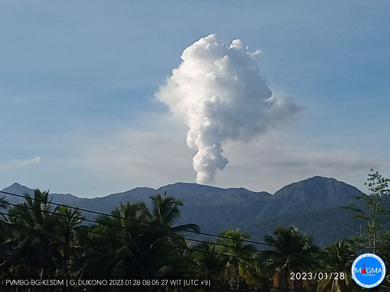
Meet Dukono, on a remote but populated Indonesia island:

268010_BGVN_033.jpg


It has been doing that since around 1933. Often the column is a little larger and gray with ash as Dukono pops off a vulcanian blast.

Sometimes it does this for a change, as in December 2023:


Indonesian volcanologists have Dukono at Level 2 (out of 4), with a 2-km exclusion zone -- while unofficially probably aware that some locals and a few foreign volcanophiles would consider it a suggestion, if not a challenge, no matter how hard they tried to enforce the zone.

It's human nature, not specific to any one locale. For example, people do this at Popocatepetl, and occasionally rangers have to go in.

The following comments are about someone's actions, not judging those people at all - I'd have to work through a big load of personal Stupid before I could even start to think about judging anyone else.

But these actions, although they provide incredible video, are nothing but reckless endangerment of self and of anyone who has to rescue them or carry out their bodies.

Meet Stupid:


Meet STUPID (but lucky):


AAAGH! Don't do that -- I don't want to watch you die!
 
Didn't realize that there's a photograph from the 1883 Krakatoa eruption until today:

20240826_174728.jpg


It is from an earlier stage of things, in May, I think.

On August 26, Krakatoa had gone way past that point (which is why I was thinking about it today), and already the tsunamis were coming. The morning of August 27th was the end. And not just of Krakatoa Island. :(

Less than fifty years later, a volcano reappeared at that location out in the Sunda Strait: Anak Krakatau, the "Child of Krakatoa."
 
Some magmatic shenanigans going on at Kilauea in a remote area:


HVO has raised the alert to Watch/ORANGE.

There reportedly is nothing special going on at Mauna loa.

Edit: More information and background here.
 
Last edited:
It did erupt. Last night. Once. Huh!


Two Pineapples will be on it if another breakout occurs and they can reach it for live coverage.


Volcano: Kilauea (VNUM #332010)

Current Volcano Alert Level: WATCH
Current Aviation Color Code: ORANGE

Issued: Monday, September 16, 2024, 11:33 AM HST
Source: Hawaiian Volcano Observatory
Notice Number: 2024/H326
Location: N 19 deg 25 min W 155 deg 17 min
Elevation: 4091 ft (1247 m)
Area: Hawaii

Volcanic Activity Summary:
Kīlauea volcano erupted briefly last night, September 15, 2024, on the middle East Rift Zone in Hawaiʻi Volcanoes National Park. The Volcano Alert Level for ground-based hazards remains at WATCH and the Aviation Color Code remains at ORANGE at this time. Rates of seismicity and ground deformation beneath the summit, lower East Rift Zone, and Southwest Rift Zone remain low. Current activity is restricted to Kīlaueaʻs upper-to-middle East Rift Zone.
Kīlauea volcano erupted briefly last night just west of Nāpau Crater on the middle East Rift Zone. This eruption, which is now over, likely occurred between approximately 9:00 and 10:00 p.m. HST on Sunday 15, 2024, in a remote and closed area of Hawaiʻi Volcanoes National Park. Chain of Craters Road, which is closed, is located downslope and downwind of the new fissures. Continued degassing from the fissure system may pose a hazard to humans downwind of the eruption site. The eruption does not currently pose an immediate threat to human life or infrastructure.
The eruption took place near the National Park Nāpau campsite (east of Kānenuiohamo and Makaopuhi Crater and west of Nāpau Crater). Small lava pads erupted from two fissure segments in a couple hundred meters (hundred yards). The lava extended 50 or so meters (yards) from the fissure vents, with the uprift fissure segment being larger than the downrift fissure segment. The eruption does not appear to have impacted Napau campground, but may have partly covered the pulu (Hawaiian tree fern) station nearby. Vegetation in the eruption area was burned and sulfur dioxide continues to de-gas from the vents. Residents of nearby subdivisions reported smelling volcanic gas and other smells related to this event during the evening of September 15.
HVO is continuing to closely monitor the middle East Rift Zone and in contact with Hawai‘i Volcanoes National Park and the Hawai‘i County Civil Defense Agency. Temporary closures have been implemented as a result of this elevated activity; please see the Hawaiʻi Volcanoes National Park website for visitor information: https://www.nps.gov/havo/index.htm. 

...
 
The eruption resumed last evening -- details here.


It's remote, but Chain of Craters Road is downwind and closed. They also warn that residents may note some gas, but this eruption isn't a hazard to life and property yet. Not all of the USGS online Kilauea sites are updated yet, but that VAN linked above is official, and in it, Kilauea is still at Aviation Code Orange.
 
Last edited:
Cam link (it's fogged in now, but the sun will probably clear that up later). Nice for all of us that HVO uses those portable cams in their work! :)

Edit -- Also:

Kilauea USGS updates and from the bottom of that page:

More Information:


The Hawaiian Volcano Observatory is one of five volcano observatories within the U.S. Geological Survey and is responsible for monitoring volcanoes and earthquakes in Hawaiʻi and American Samoa.


CONTACT INFORMATION:

[email protected]


Subscribe to these messages: https://volcanoes.usgs.gov/vns2/
Summary of volcanic hazards from eruptions: https://www.usgs.gov/observatories/hvo/hazards
Recent earthquakes in Hawaiʻi (map and list): https://www.usgs.gov/observatories/hvo
Explanation of Volcano Alert Levels and Aviation Color Codes: https://www.usgs.gov/programs/VHP/volcanic-alert-levels-characterize-conditions-us-volcanoes
 
Last edited:
The plume is bigger but overall it still seems fairly small.

HAWAIIAN VOLCANO OBSERVATORY STATUS REPORT
U.S. Geological Survey
Tuesday, September 17, 2024, 5:55 AM HST (Tuesday, September 17, 2024, 15:55 UTC)


KILAUEA
(VNUM #332010)
19°25'16" N 155°17'13" W, Summit Elevation 4091 ft (1247 m)
Current Volcano Alert Level: WATCH
Current Aviation Color Code: ORANGE


Activity Summary: Kīlauea volcano is erupting near Makaopuhi Crater in Hawai’i Volcanoes National Park. Eruptive activity increased this morning between 4:00 and 5:00 AM HST based on monitoring data from seismicity, infrasound, webcam imagery, and GOES satellite thermal imagery. There is no immediate threat to life or infrastructure. The Volcano Alert Level/Aviation Color Code remains at WATCH/ORANGE. All current and recent activity is within Hawaiʻi Volcanoes National Park. No changes have been detected in the lower East Rift Zone or Southwest Rift Zone.

Current eruptive activity began with a small eruption that occurred on September 15, 2024, on a remote section of the middle East Rift Zone in Hawaiʻi Volcanoes National Park, just west of Nāpau Crater as described here: September 16, 2024 —Kīlauea middle East Rift Zone eruption reference map | U.S. Geological Survey (usgs.gov)

A reference map of the middle East Rift Zone, with past lava flow extents, is available here: https://www.usgs.gov/maps/kilauea-middle-east-rift-zone-reference-map.
 
Back
Top