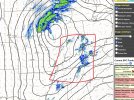
Storms firing in that area right now, and one is already severe warned. Any development in this area is what really needs to be watched as it moves east.Yes! They see it. It's 70 degree with a dew in the mid to upper 60s in this area.
View attachment 24746
Now the big question is storm mode. Will it be a swarm of supercells, or will things line out and grow upscale?