
Navigation
Install the app
How to install the app on iOS
Follow along with the video below to see how to install our site as a web app on your home screen.
Note: This feature may not be available in some browsers.
More options
-
Welcome to TalkWeather! We see you lurking around TalkWeather! Take the extra step and join us today to view attachments, see less ads and maybe even join the discussion. CLICK TO JOIN TALKWEATHER
You are using an out of date browser. It may not display this or other websites correctly.
You should upgrade or use an alternative browser.
You should upgrade or use an alternative browser.
Svr Wx threat April 1-April 2 2024
- Thread starter KevinH
- Start date
- Thread starter
- #22
KevinH
Member
Tee hee
Justin Hindman
Member
- Messages
- 378
- Reaction score
- 1,165
- Location
- Gardendale Alabama
- Special Affiliations
- SKYWARN® Volunteer
- ARRL Member
Spc will issue a 10 percent enhanced with unsure or what will happen lol. In all seriousness, looking forward to seeing models closer to this event
- Thread starter
- #24
KevinH
Member
Me:Spc will issue a 10 percent enhanced with unsure or what will happen lol. In all seriousness, looking forward to seeing models closer to this event

Mrgolfman7070
Member
I'm definitely not an expert svr wx person, but getting a high risk is almost similar to getting a blizzard in the south, but perhaps not as extreme. Still hoping for some action for the mid south!!
- Thread starter
- #26
KevinH
Member
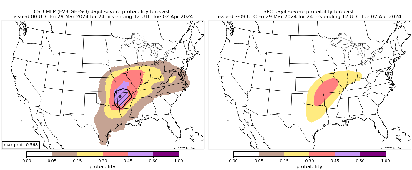
SPC (Broyles, everyone’s FAVORITE LOL) highlights a 30% risk area for Monday, April 1 for parts of the Midwest.
Day 4 (4-1-2024)

Day 5 (4-2-2024)

Day 4-8 Convective Outlook
NWS Storm Prediction Center Norman OK
0519 AM CDT Fri Mar 29 2024
Valid 011200Z - 061200Z
...Monday/Day 4...
An upper-level trough is forecast to move eastward across the Four Corners region on Monday, as strong southwest mid-level flow remains in place from the southern Plains into the mid Mississippi Valley. Early in the day, an east-to-west boundary is forecast from northern Missouri eastward into the Ohio Valley, along which will likely focus elevated thunderstorm development from Monday morning into the afternoon. Large hail could occur with some of the more intense storms. The severe threat is expected to persist into the evening, and possibly into the overnight period as an MCS moves into the region from the west-southwest
Further southwest, a moist airmass is forecast to be in place from northeast Texas into eastern Oklahoma and eastern Kansas, extending eastward into the mid Mississippi Valley. A surface low is forecast to develop over the central Plains, as a 75 to 90 knot mid-level jet ejects northeastward across the southern Plains. As the nose of the jet moves over the moist and unstable airmass during the afternoon and evening, widespread severe weather is expected to occur. Strong deep-layer shear and steep lapse rates are forecast to be favorable for a large-hail threat with supercells across parts of Texas, Oklahoma and Kansas eastward into the lower Missouri Valley. Tornadoes and wind damage will also be possible, especially as the low-level jet strengthens and an MCS organizes across the region during the evening. The MCS is expected to remain severe into the overnight period, moving eastward into the Mid Mississippi Valley.
...Tuesday/Day 5...
The upper-level system is forecast to move eastward into the Ozarks and mid Mississippi Valley on Tuesday. An associated cold front will likely move quickly eastward into the mid Mississippi Valley early in the day. Ahead of the front, a moist and unstable airmass is expected to be in place by midday, with scattered to numerous thunderstorms developing in the Ohio and Tennessee Valleys in the afternoon. The mid-level jet is forecast to move into the Ohio Valley by late afternoon, suggesting that a widespread severe threat will be possible. Strong deep-layer shear and lift associated with the jet would be favorable for supercells with a threat for wind damage, large hail and some tornadoes. The severe threat is forecast to extend southward into the Tennessee Valley, and eastward into the Mid-Atlantic, where scattered severe storms will be possible within a moist and unstable airmass.
...Wednesday/Day 6 to Friday/Day 8...
An upper-level low is forecast to move through the Ohio Valley on Wednesday as a cold front advances eastward to the Atlantic Seaboard. A severe threat would be possible ahead of the front during the day from the Mid-Atlantic southward into the eastern Carolinas. However, the timing of the front and the magnitude of any
severe potential are uncertain at this time. Model consensus suggests that the severe threat should be less widespread than on previous days further west.
On Thursday and Friday, a large area of high pressure is forecast to move into the central and eastern U.S. This will reduce the potential for thunderstorm development across most of the U.S.
Day 4 (4-1-2024)
Day 5 (4-2-2024)
Day 4-8 Convective Outlook
NWS Storm Prediction Center Norman OK
0519 AM CDT Fri Mar 29 2024
Valid 011200Z - 061200Z
...Monday/Day 4...
An upper-level trough is forecast to move eastward across the Four Corners region on Monday, as strong southwest mid-level flow remains in place from the southern Plains into the mid Mississippi Valley. Early in the day, an east-to-west boundary is forecast from northern Missouri eastward into the Ohio Valley, along which will likely focus elevated thunderstorm development from Monday morning into the afternoon. Large hail could occur with some of the more intense storms. The severe threat is expected to persist into the evening, and possibly into the overnight period as an MCS moves into the region from the west-southwest
Further southwest, a moist airmass is forecast to be in place from northeast Texas into eastern Oklahoma and eastern Kansas, extending eastward into the mid Mississippi Valley. A surface low is forecast to develop over the central Plains, as a 75 to 90 knot mid-level jet ejects northeastward across the southern Plains. As the nose of the jet moves over the moist and unstable airmass during the afternoon and evening, widespread severe weather is expected to occur. Strong deep-layer shear and steep lapse rates are forecast to be favorable for a large-hail threat with supercells across parts of Texas, Oklahoma and Kansas eastward into the lower Missouri Valley. Tornadoes and wind damage will also be possible, especially as the low-level jet strengthens and an MCS organizes across the region during the evening. The MCS is expected to remain severe into the overnight period, moving eastward into the Mid Mississippi Valley.
...Tuesday/Day 5...
The upper-level system is forecast to move eastward into the Ozarks and mid Mississippi Valley on Tuesday. An associated cold front will likely move quickly eastward into the mid Mississippi Valley early in the day. Ahead of the front, a moist and unstable airmass is expected to be in place by midday, with scattered to numerous thunderstorms developing in the Ohio and Tennessee Valleys in the afternoon. The mid-level jet is forecast to move into the Ohio Valley by late afternoon, suggesting that a widespread severe threat will be possible. Strong deep-layer shear and lift associated with the jet would be favorable for supercells with a threat for wind damage, large hail and some tornadoes. The severe threat is forecast to extend southward into the Tennessee Valley, and eastward into the Mid-Atlantic, where scattered severe storms will be possible within a moist and unstable airmass.
...Wednesday/Day 6 to Friday/Day 8...
An upper-level low is forecast to move through the Ohio Valley on Wednesday as a cold front advances eastward to the Atlantic Seaboard. A severe threat would be possible ahead of the front during the day from the Mid-Atlantic southward into the eastern Carolinas. However, the timing of the front and the magnitude of any
severe potential are uncertain at this time. Model consensus suggests that the severe threat should be less widespread than on previous days further west.
On Thursday and Friday, a large area of high pressure is forecast to move into the central and eastern U.S. This will reduce the potential for thunderstorm development across most of the U.S.
Last edited:
warneagle
Member
SPC (Broyles, everyone’s FAVORITE LOL) highlights a 30% risk area for Monday, April 1 for parts of the Midwest.
Day 4 (4-1-2024)
Day 5 (4-2-2024)
Day 4-8 Convective Outlook
NWS Storm Prediction Center Norman OK
0519 AM CDT Fri Mar 29 2024
Valid 011200Z - 061200Z
...Monday/Day 4...
An upper-level trough is forecast to move eastward across the Four Corners region on Monday, as strong southwest mid-level flow remains in place from the southern Plains into the mid Mississippi Valley. Early in the day, an east-to-west boundary is forecast from northern Missouri eastward into the Ohio Valley, along which will likely focus elevated thunderstorm development from Monday morning into the afternoon. Large hail could occur with some of the more intense storms. The severe threat is expected to persist into the evening, and possibly into the overnight period as an MCS moves into the region from the west-southwest
Further southwest, a moist airmass is forecast to be in place from northeast Texas into eastern Oklahoma and eastern Kansas, extending eastward into the mid Mississippi Valley. A surface low is forecast to develop over the central Plains, as a 75 to 90 knot mid-level jet ejects northeastward across the southern Plains. As the nose of the jet moves over the moist and unstable airmass during the afternoon and evening, widespread severe weather is expected to occur. Strong deep-layer shear and steep lapse rates are forecast to be favorable for a large-hail threat with supercells across parts of Texas, Oklahoma and Kansas eastward into the lower Missouri Valley. Tornadoes and wind damage will also be possible, especially as the low-level jet strengthens and an MCS organizes across the region during the evening. The MCS is expected to remain severe into the overnight period, moving eastward into the Mid Mississippi Valley.
...Tuesday/Day 5...
The upper-level system is forecast to move eastward into the Ozarks and mid Mississippi Valley on Tuesday. An associated cold front will likely move quickly eastward into the mid Mississippi Valley early in the day. Ahead of the front, a moist and unstable airmass is expected to be in place by midday, with scattered to numerous thunderstorms developing in the Ohio and Tennessee Valleys in the afternoon. The mid-level jet is forecast to move into the Ohio Valley by late afternoon, suggesting that a widespread severe threat will be possible. Strong deep-layer shear and lift associated with the jet would be favorable for supercells with a threat for wind damage, large hail and some tornadoes. The severe threat is forecast to extend southward into the Tennessee Valley, and eastward into the Mid-Atlantic, where scattered severe storms will be possible within a moist and unstable airmass.
...Wednesday/Day 6 to Friday/Day 8...
An upper-level low is forecast to move through the Ohio Valley on Wednesday as a cold front advances eastward to the Atlantic Seaboard. A severe threat would be possible ahead of the front during the day from the Mid-Atlantic southward into the eastern Carolinas. However, the timing of the front and the magnitude of any
severe potential are uncertain at this time. Model consensus suggests that the severe threat should be less widespread than on previous days further west.
On Thursday and Friday, a large area of high pressure is forecast to move into the central and eastern U.S. This will reduce the potential for thunderstorm development across most of the U.S.
Attachments

NorthGaWeather
Member
Broyles is a treat compared to some of the mesoscale/outlook forecasters in the 90s/00s. I still have nightmares from Dial’s shifts.
I think these are the highest Day 4 probs Ive seen on here since March and early April last year!
Does anyone know of or have a link to the warning/watch graphics that the NWS puts out on their twitter feeds with population, etc.?
If you're inquiring about templates, I've yet to see anything of the sort, but I imagine they wouldn't be too difficult to re-create or at least proximate in a photo editor.Does anyone know of or have a link to the warning/watch graphics that the NWS puts out on their twitter feeds with population, etc.?


Sidenote: I'm gonna be a guest on Weatherbrains April 22nd (Weather dependent of course). I'll be discussing Hurricane Season and what all I've been working on data collecting wise.


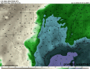
Meanwhile @Clancy Memphis upgraded from no severe weather to at least a chance of severe weather in the morning AFD next week.....12Z GFS coming in with more of the some. The wind fields are so far not particularly favorable, but the moisture, instability and lapse rates are decent. Soundings from North-Central GA and East AL, respectively.
View attachment 24499View attachment 24500
Hey, it's an improvement!Meanwhile @Clancy Memphis upgraded from no severe weather to at least a chance of severe weather in the morning AFD next week.....
Yeah LOL!Hey, it's an improvement!
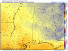
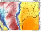
All 12z Global runs showing widespread dewpoints in the mid 60s to low 70s 00z Monday thru 18z Tuesday/06z Wednesday.
Attachments
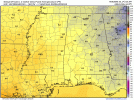
18z GFS keeps the trend as the 12z runs on widespread mid/high dewpoints. Also of note, this latest run seems to be slower in progression with the cold front which could mean a multi-day event. If trends continue overnight with both widespread dewpoints and a slower progression of front, I would anticipate that the Day 5 risk gets expanded further west and south with the current Day 4 risk getting expanded east and south.
Basically, in simple terms, this is looking like a legitimate threat. And by legitimate I mean greater than what we dealt with this past week.
Basically, in simple terms, this is looking like a legitimate threat. And by legitimate I mean greater than what we dealt with this past week.
Attachments
Last edited: