CheeselandSkies
Member
It's early yet but based on the first sniff of the NAM, my virtual target would be west-central MS. Indices are slightly greater further W over AR, but I'm seeing some VBV issues in the soundings there. Instability issues further north. What an outbreak this system would be in late May with low-level instability overriding the warm front.
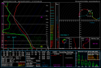
*Hodo looks decent to me in this sounding but the wind barbs, especially from 850 up to 700mb, look rather unidirectional with perhaps some very slight backing (although not as much as farther west), then only gradual veering as you go further up. That could be an issue despite the decent low-level turning.
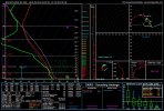
*Hodo looks decent to me in this sounding but the wind barbs, especially from 850 up to 700mb, look rather unidirectional with perhaps some very slight backing (although not as much as farther west), then only gradual veering as you go further up. That could be an issue despite the decent low-level turning.
Attachments
Last edited: