manofthenaders23
Member
Oh yeah, LCL's by all accounts were very low that day and the environment in N AL on 4/27, above the thermal boundary that had settled across the area, was probably pretty similar. Very low T-Td spreads. If any photo exists, I'd think it would come from the Murphysboro or West Frankfurt area, those being the largest towns in the direct path of the tornado. Unlikely though.
Moving on, here's a pretty spectacular color photograph of the 1966 Topeka tornado

And some interesting pictures from some of the worst-affected areas

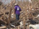
I suspect some cleanup had occurred prior to this photograph being taken


Impressive tree damage outside of town

Likely a case where the tornado was strongest outside of town to the west and gradually weakened as it moved through the city. The aerial photographs show damage was strongest on the west side of Topeka, immediately after it crested Burnett's mound, which is visible in the background of the third picture. Similar to Chandler, MN before the 1992 tornado, some residents of Topeka believed that Burnett's mound would disrupt any tornado approaching the town from the SW. Obviously, no such thing occurred in both cases. Perhaps this lends some anecdotal credence to the idea that tornadoes are prone to weakening on the upslope of a hill and strengthening on the downslope. I believe a UAH study conducted after 04/27(possibly already posted in this thread?) was the first to promote that theory or at least the first to flesh it out with observations on the ground/modern technology.
Moving on, here's a pretty spectacular color photograph of the 1966 Topeka tornado
And some interesting pictures from some of the worst-affected areas
I suspect some cleanup had occurred prior to this photograph being taken
Impressive tree damage outside of town
Likely a case where the tornado was strongest outside of town to the west and gradually weakened as it moved through the city. The aerial photographs show damage was strongest on the west side of Topeka, immediately after it crested Burnett's mound, which is visible in the background of the third picture. Similar to Chandler, MN before the 1992 tornado, some residents of Topeka believed that Burnett's mound would disrupt any tornado approaching the town from the SW. Obviously, no such thing occurred in both cases. Perhaps this lends some anecdotal credence to the idea that tornadoes are prone to weakening on the upslope of a hill and strengthening on the downslope. I believe a UAH study conducted after 04/27(possibly already posted in this thread?) was the first to promote that theory or at least the first to flesh it out with observations on the ground/modern technology.
Last edited: