
I'd like more detail on where the photo was supposedly taken. The second tornado was supposed to have been F4 and fairly wide in the Harvest area. While the April 27 Cordova tornado presented a similar appearance at times, at least one instance when it did, it was weaker. It's not impossible it's the first tornado near the end of its life.Is it just me, or does this image just scream "4/3/74 KY/IN/OH tornado"? If that's a tornado at all - hard to determine ground contact and it may just be a funnel aloft.
Update: Oh barnacles this may actually be legit :O
Navigation
Install the app
How to install the app on iOS
Follow along with the video below to see how to install our site as a web app on your home screen.
Note: This feature may not be available in some browsers.
More options
-
Welcome to TalkWeather! We see you lurking around TalkWeather! Take the extra step and join us today to view attachments, see less ads and maybe even join the discussion. CLICK TO JOIN TALKWEATHER
You are using an out of date browser. It may not display this or other websites correctly.
You should upgrade or use an alternative browser.
You should upgrade or use an alternative browser.
Significant Tornado Events
- Thread starter locomusic01
- Start date
Lake Martin EF4
Member
Not sure if you're referring to specifically in Harvest or the overall rating, but I'm also just gonna say it right now - the F5 rating for Tanner #2, though likely applied in error, is appropriate when looking at some of the lesser known damage pictures.The second tornado was supposed to have been F4 and fairly wide in the Harvest area.
speedbump305
Member
I consider Tanner #2 a lot more violent than some of the other F5s that occurred that day such as Sayler Park, OH.Not sure if you're referring to specifically in Harvest or the overall rating, but I'm also just gonna say it right now - the F5 rating for Tanner #2, though likely applied in error, is appropriate when looking at some of the lesser known damage pictures.
SouthFLwx
Member
This is a very good write up and I think you should do more of these. Also, I remember this tornado quite clearly. It was definitely violent and likely would have gotten the rating had it hit more structures at it's peak intensity.Time for one of AJS’s write ups! ( Yes it’s me, just on my old account lol )
In my opinion, one of the more less talked about significant tornadoes of the 21st century is the long tracked Brent/Centreville EF3 that occurred on March 25, 2021. This beast was on the ground for around 80 miles and 1 hour and 38 minutes as it churned through areas near Brent/Centreville. While officially rated EF3, I have absolutely little doubt in my mind it would have been rated EF4 had it hit one of the towns head on. Brent and Centreville got very lucky that day as the CC/Vrot signature were certainly indicative of a high end event. Was almost certainly more intense than the Newnan, GA “ EF4 “
Below are some damage photos showing some fairly severe tree damage with significant debarking/denuding and a satellite image showing the extensive forestry damage this beast produced. Along with the radar signature and a eerie photo of the monster.View attachment 52149View attachment 52150View attachment 52151View attachment 52152View attachment 52153View attachment 52154
speedbump305
Member
Thanks man! Had a lot more free time lately to do some write ups for the forum so a lot more will be coming!This is a very good write up and I think you should do more of these. Also, I remember this tornado quite clearly. It was definitely violent and likely would have gotten the rating had it hit more structures at its peak intensity.
And 100% agreed. Definitely would have gotten a violent rating if it had hit more structures at peak intensity. The forest/tree damage reminds me of the tree damage from Lake City, AR tornado last year. Which was another beast that certainly stronger than the rating it was given.
Juliett Bravo Kilo
Member
Given the rapid forward speed, 200+ miles likely is feasible. The fact that the damage is F5 constantly the entire path points to it likely being a single tornado.I mentioned it in the anniversaries thread. Probably not much to say that hasn't already been said, and last year was the 100th anniversary.
Remains (and probably always will) quite the meteorological enigma given the nature of tornado observations and damage surveying at the time. I do believe the December 2021 Quad-State Supercell gave us quite likely the closest thing we will ever see to revealing the nature of what actually occurred that day. I could see a rapid cycle between two or more long track violent tornadoes being easily missed, especially with the gap obfuscated in surveys/eyewitness accounts by brief touchdowns and/or RFD damage (both of which occurred in Obion Co., TN). I just don't believe a single tornado track well in excess of 200 miles is physically possible.
speedbump305
Member
On May 25, 2016, one of the most violent tornadoes of the 21st century in my opinion occurred. Touching down at 7:07 PM NE of the community of Niles, this beast traveled a total of of 25.08 miles throughout rural Kansas as it tracked near the towns/communities of Abilene, Solomon, and Chapman. It was on the ground for 93 minutes until 8:40 PM. Touching down NE of Niles in Ottawa County, the tornado gradually began to strengthen quickly as it crossed the intersection of Buffalo and North 290th roads. It was at this time when it reached EF2 strength and began producing significant damage. After crossing Buckeye Creek, it become very intense and reached EF3 strength and impacted a home north of Solomon. Shortly after, it twisted/snapped some trees at EF2 intensity as it left Ottawa county into Dickinson county.
As the tornado passed South of Talmage, KS intensity increased once again as it reached EF2/EF3 strength as it destroyed a residence and collapsing the walls of another home as it passed to the north of Abilene. A home nearby was considerably damaged at EF2 intensity as well. Once again, the tornado intensified dramatically as it crossed Hawk Road and leveled a home this time at high end EF3 strength. A lot of the debris was swept off the foundation as well. A family at this residence thankfully took shelter in the basement bathroom and survived. Once again, the tornado dramatically weakened back to high end EF1/low end EF2 strength.
As the tornado gradually approached the city limits of Chapman, it became extremely violent as it completely bent and twisted railroads and debarking low lying shrubbery and trees by the tracks. Shortly after, it impacted a farm stead at EF4 strength.
However, I highly believe this home experienced winds significantly higher as the foundation walls of the home were cracked which takes an insane amount of force! It was a pretty well built home as well. Around this area as well, it began producing extraordinary contextual damage, particularly around US-40 such as violently mangling vehicles to such an extreme extent, some were unrecognizable, intense ground scouring, complete debarking of trees/low lying shrubbery, and intense rowing/granulation of debris. The final rating of EF4 for this tornado has sparked controversy and in my opinion, rightfully so.
Damage photos/photos of the tornado below:
Attachments
Last edited:
WeathermanLeprechaun
Member
Superb breakdown but.... Can't believe we're calling out future violent tornadoes. May 25, 2026!On May 25, 2026, one of the most violent tornadoes of the 21st century in my opinion occurred. Touching down at 7:07 PM NE of the community of Niles, this beast traveled a total of of 25.08 miles throughout rural Kansas as it tracked near the towns/communities of Abilene, Solomon, and Chapman. It was on the ground for 93 minutes until 8:40 PM. Touching down NE of Niles in Ottawa County, the tornado gradually began to strengthen quickly as it crossed the intersection of Buffalo and North 290th roads. It was at this time when it reached EF2 strength and began producing significant damage. After crossing Buckeye Creek, it become very intense and reached EF3 strength and impacted a home north of Solomon. Shortly after, it twisted/snapped some trees at EF2 intensity as it left Ottawa county into Dickinson county.
As the tornado passed South of Talmage, KS intensity increased once again as it reached EF2/EF3 strength as it destroyed a residence and collapsing the walls of another home as it passed to the north of Abilene. A home nearby was considerably damaged at EF2 intensity as well. Once again, the tornado intensified dramatically as it crossed Hawk Road and leveled a home this time at high end EF3 strength. A lot of the debris was swept off the foundation as well. A family at this residence thankfully took shelter in the basement bathroom and survived. Once again, the tornado dramatically weakened back to high end EF1/low end EF2 strength.
As the tornado gradually approached the city limits of Chapman, it became extremely violent as it completely bent and twisted railroads and debarking low lying shrubbery and trees by the tracks. Shortly after, it impacted a farm stead at EF4 strength.
However, I highly believe this home experienced winds significantly higher as the foundation walls of the home were cracked which takes an insane amount of force! It was a pretty well built home as well. Around this area as well, it began producing extraordinary contextual damage, particularly around US-40 such as violently mangling vehicles to such an extreme extent, some were unrecognizable, intense ground scouring, complete debarking of trees/low lying shrubbery, and intense rowing/granulation of debris. The final rating of EF4 for this tornado has sparked controversy and in my opinion, rightfully so.
Damage photos/photos of the tornado below:
View attachment 52166View attachment 52167View attachment 52168View attachment 52169View attachment 52170View attachment 52172View attachment 52173View attachment 52174View attachment 52175
It's all good, this is a brilliant breakdown here and I fully agree this is a tornado that doesn't necessarily get the attention it deserves. It was VERY high end. Also it was unusually long lived for a Plains tornado
speedbump305
Member
Oh my goodness! I didn’t even realize that lol. I blame the heat and allergies LMAO.Superb breakdown but.... Can't believe we're calling out future violent tornadoes. May 25, 2026!
It's all good, this is a brilliant breakdown here and I fully agree this is a tornado that doesn't necessarily get the attention it deserves. It was VERY high end. Also it was unusually long lived for a Plains tornado
And I couldn’t agree more man. It was an insanely violent tornado and to be honest, I feel like it’s on par with tornadoes such as Chickasha and Goldsby.
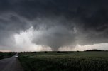
No, you've got hold of the wrong end of the stick. I'm referring to the path width and intensity in that area not being consistent with that photograph. While of course there's 'you can't judge intensity from appearance', if we look at some of the April 27 tornadoes (Tuscaloosa, Cullman, Cordova), they were more visually imposing when they were more intense.Not sure if you're referring to specifically in Harvest or the overall rating, but I'm also just gonna say it right now - the F5 rating for Tanner #2, though likely applied in error, is appropriate when looking at some of the lesser known damage pictures.
That's why without further context if you were to ask me which tornado is depicted, I'd have said it was the first one, which dissipated somewhere south of Harvest, with the dashed line on Fujita's map perhaps being indicative of some uncertainty as to where it did.

joshoctober16
Member
its to note that nws did made a list of tornadoes that are likely the same strength or stronger then bridge creek , so having it as 321 mph makes a bunch of other tornadoes in the possible F6.That's funny, I always used to hear its peak wind cited as "318 MPH (the theoretical upper bound of the F5 range*) +/- 3," so if officially recorded at 321 MPH wouldn't that make it technically an "inconceivable" F6? Of course, that would open a whole other can of worms with the way the EF-scale and its associated wind speed boundaries have been used for the last ~13 years.
*Although, IIRC the very first time I remember seeing the Fujita scale in a weather book as a kid, it left the upper bound of F5 open, as in "261 MPH+," which IMO made more sense even then since the practical applications for a higher rating were never defined.
The dashed lines indicate “funnel aloft” per Fujita’s map. I think you nailed it.No, you've got hold of the wrong end of the stick. I'm referring to the path width and intensity in that area not being consistent with that photograph. While of course there's 'you can't judge intensity from appearance', if we look at some of the April 27 tornadoes (Tuscaloosa, Cullman, Cordova), they were more visually imposing when they were more intense.
That's why without further context if you were to ask me which tornado is depicted, I'd have said it was the first one, which dissipated somewhere south of Harvest, with the dashed line on Fujita's map perhaps being indicative of some uncertainty as to where it did.
View attachment 52176


WeathermanLeprechaun
Member
A bunch of tornadoes that day were extremely violent but mostly went under the radar. Even documentation for such a outbreak wasn't too idealSpeaking of 4/3/74, the Fentress Co. TN - Wayne Co. KY F4 tornado seemed to have been incredibly violent, but tends to fly under the radar. Same thing with the Mannsville, KY F4.
View attachment 52179
View attachment 52180
speedbump305
Member
On May 10, 2015 one of the most underrated tornadoes since the establishment of the EF Scale in my opinion touched down in South Dakota on mother’s day. The Delmont, SD tornado. This tornado was rated EF2 with winds of around 130 mph and every time I get the chance to look at damage photos from this event, I genuinely get so pissed off it’s not even funny. Below, I will post copious damage photos that show that the tornado was NOT en “ EF2. “
The tornado touched down at 10:21 NE of Wagner and was on the ground until 10:52. So a fairly long track tornado by plains standards. The tornado was also moving at a pretty decent forward speed at around 30-32 mph as it traveled mostly along open country throughout its time in Charles Mix County.
According to the survey, after it crossed into Douglas county, it impacted a farmstead at EF2 strength and as it approached Delmont from the SW, it impacted a few more farmsteads as it continued to strengthen.
The tornado made a direct impact on Delmont at around 10:45 AM and in my opinion, at EF4 strength. As it moved through Delmont, numerous violent damage indicators were present. Perhaps the most infamous being a mangled vehicle twisted in a significantly debarked tree. Perhaps most impressively, the tornado left a fairly significant swath of grass/ground scouring that really isn’t seen in tornadoes weaker than low end EF4. In addition to this, the tornado damaged/destroyed numerous homes in Delmont with a few being completely leveled. There was some fairly noticeable wind rowing as well. Now, I am unaware of the construction of some of these homes, and rural plains residences are not known for being the most well constructed, but the damage shown below being rated EF2 genuinely makes no sense to me. I would have been much more okay with a high end EF3 rating and maybe low end EF4 given the violent contextuals present. EF2 tornadoes do NOT cause grass scouring present below. And as @buckeye05 mentioned, grass scouring that occurs a long a fairly wide and lengthy swath is always indicative of a very intense tornado. Regardless, the rating of this tornado does not take away the devastation Delmont dealt with and over 10 years later, they thankfully seemed to have made a very strong recovery!
Below are damage photos/radar imagery/ and a photo of the tornado.


“ EF2. “ Lol.
The tornado touched down at 10:21 NE of Wagner and was on the ground until 10:52. So a fairly long track tornado by plains standards. The tornado was also moving at a pretty decent forward speed at around 30-32 mph as it traveled mostly along open country throughout its time in Charles Mix County.
According to the survey, after it crossed into Douglas county, it impacted a farmstead at EF2 strength and as it approached Delmont from the SW, it impacted a few more farmsteads as it continued to strengthen.
The tornado made a direct impact on Delmont at around 10:45 AM and in my opinion, at EF4 strength. As it moved through Delmont, numerous violent damage indicators were present. Perhaps the most infamous being a mangled vehicle twisted in a significantly debarked tree. Perhaps most impressively, the tornado left a fairly significant swath of grass/ground scouring that really isn’t seen in tornadoes weaker than low end EF4. In addition to this, the tornado damaged/destroyed numerous homes in Delmont with a few being completely leveled. There was some fairly noticeable wind rowing as well. Now, I am unaware of the construction of some of these homes, and rural plains residences are not known for being the most well constructed, but the damage shown below being rated EF2 genuinely makes no sense to me. I would have been much more okay with a high end EF3 rating and maybe low end EF4 given the violent contextuals present. EF2 tornadoes do NOT cause grass scouring present below. And as @buckeye05 mentioned, grass scouring that occurs a long a fairly wide and lengthy swath is always indicative of a very intense tornado. Regardless, the rating of this tornado does not take away the devastation Delmont dealt with and over 10 years later, they thankfully seemed to have made a very strong recovery!
Below are damage photos/radar imagery/ and a photo of the tornado.
“ EF2. “ Lol.
WeathermanLeprechaun
Member
That radar presentation is oddly similar to the Greenfield EF4. A small but tight couplet and a huge cc blowup over town. Don't understand why this was given a EF2 rating whatsoever.
atOn May 10, 2015 one of the most underrated tornadoes since the establishment of the EF Scale in my opinion touched down in South Dakota on mother’s day. The Delmont, SD tornado. This tornado was rated EF2 with winds of around 130 mph and every time I get the chance to look at damage photos from this event, I genuinely get so pissed off it’s not even funny. Below, I will post copious damage photos that show that the tornado was NOT en “ EF2. “
The tornado touched down at 10:21 NE of Wagner and was on the ground until 10:52. So a fairly long track tornado by plains standards. The tornado was also moving at a pretty decent forward speed at around 30-32 mph as it traveled mostly along open country throughout its time in Charles Mix County.
According to the survey, after it crossed into Douglas county, it impacted a farmstead at EF2 strength and as it approached Delmont from the SW, it impacted a few more farmsteads as it continued to strengthen.
The tornado made a direct impact on Delmont at around 10:45 AM and in my opinion, at EF4 strength. As it moved through Delmont, numerous violent damage indicators were present. Perhaps the most infamous being a mangled vehicle twisted in a significantly debarked tree. Perhaps most impressively, the tornado left a fairly significant swath of grass/ground scouring that really isn’t seen in tornadoes weaker than low end EF4. In addition to this, the tornado damaged/destroyed numerous homes in Delmont with a few being completely leveled. There was some fairly noticeable wind rowing as well. Now, I am unaware of the construction of some of these homes, and rural plains residences are not known for being the most well constructed, but the damage shown below being rated EF2 genuinely makes no sense to me. I would have been much more okay with a high end EF3 rating and maybe low end EF4 given the violent contextuals present. EF2 tornadoes do NOT cause grass scouring present below. And as @buckeye05 mentioned, grass scouring that occurs a long a fairly wide and lengthy swath is always indicative of a very intense tornado. Regardless, the rating of this tornado does not take away the devastation Delmont dealt with and over 10 years later, they thankfully seemed to have made a very strong recovery!
Below are damage photos/radar imagery/ and a photo of the tornado.
View attachment 52181View attachment 52182View attachment 52183View attachment 52184View attachment 52185View attachment 52186View attachment 52187View attachment 52188
“ EF2. “ Lol.
Do you happen to have any of those damage photos to hand? No worries if not, just curious as I've always considered Tanner #2 not to be on par with other F5s that day.Not sure if you're referring to specifically in Harvest or the overall rating, but I'm also just gonna say it right now - the F5 rating for Tanner #2, though likely applied in error, is appropriate when looking at some of the lesser known damage pictures.
speedbump305
Member
100% agreed. There’s really no reason for the damage above to be assigned an EF2 rating. The contextual damage literally screams violent alone. High end EF3 would have honestly even been appropriate. But high end EF2? Yeah, no. 2015 as a whole had a lot of controversial ratings not gonna lie.That radar presentation is oddly similar to the Greenfield EF4. A small but tight couplet and a huge cc blowup over town. Don't understand why this was given a EF2 rating whatsoever.
at
Rochelle, IL.
Delmont, SD.
Cisco, TX.
Holly Springs/Ashland, MS.
All of these tornadoes had some sort of controversy given to the ratings they were received. But honestly, Delmont really infuriates me.
Juliett Bravo Kilo
Member
That's the first time I've seen asphalt scouring from 4/3/74. For some reason there's no mention of it with Guin, either Tanner or any other tornado from that day.Speaking of 4/3/74, the Fentress Co. TN - Wayne Co. KY F4 tornado seemed to have been incredibly violent, but tends to fly under the radar. Same thing with the Mannsville, KY F4.
View attachment 52179
View attachment 52180
speedbump305
Member
That’s honestly why I consider it an unreliable indicator. You could see it in a tornado that isn’t violent strength or see it in an extremely violent tornado. It’s an inconsistent indicator in my opinion. However, every violent/high end tornado has produced some form of significant scouring which is always my go to damage indicator to see if we are looking at a high end event.That's the first time I've seen asphalt scouring from 4/3/74. For some reason there's no mention of it with Guin, either Tanner or any other tornado from that day.