
Correct. I misworded that.WOW! Dude, that is a money shot right there! By the way not to be too nit picky here, but just letting you know that this was actually a separate tornado! This was actually the Tri State EF4 that went from Monette AR - Samburg TN, occluded and then dropped the Mayfield tornado just north of Woodland Mills, TN. What is shown in the image though is most likely the origin of the meso handoff. Looks like a new area of rotation developing in that image!
Navigation
Install the app
How to install the app on iOS
Follow along with the video below to see how to install our site as a web app on your home screen.
Note: This feature may not be available in some browsers.
More options
-
Welcome to TalkWeather! We see you lurking around TalkWeather! Take the extra step and join us today to view attachments, see less ads and maybe even join the discussion. CLICK TO JOIN TALKWEATHER
You are using an out of date browser. It may not display this or other websites correctly.
You should upgrade or use an alternative browser.
You should upgrade or use an alternative browser.
Significant Tornado Events
- Thread starter locomusic01
- Start date
Lake Martin EF4
Member
Fairly sure that's actually Monette which was the EF4 that preceded Mayfield.A picture that I took of Mayfield tornado when it was near Reelfoot Lake in Tennessee.
EDIT: Ninja'd
AJS
Member
Beat ya to it!Fairly sure that's actually Monette which was the EF4 that preceded Mayfield.
EDIT: Ninja'd


Lake Martin EF4
Member
Pretty sure the "F2" belongs in quotation marks there.Some new damage photos from the June 2, 1995 Dimmitt, TX F2. I've got more, but these are the impressive ones!
View attachment 44180View attachment 44181
That being said, though.....was there any damage, contextual or structural, pointing towards F5 intensity? I've seen that branded around, including on the most famous video of it where it explicitly identifies it as an F5.
Structural damage seems more in line with F3, contextual F4-F5 which is the car damage and pavement scouringPretty sure the "F2" belongs in quotation marks, there.
That being said, though.....was there any damage, contextual or structural, pointing towards F5 intensity? I've seen that branded around, including on the most famous video of it where it explicitly identifies it as an F5.

Juliett Bravo Kilo
Member
F2, huh? So many underrated tornadoes from June of 1995 in Texas, it seems.Some new damage photos from the June 2, 1995 Dimmitt, TX F2. I've got more, but these are the impressive ones!
View attachment 44180View attachment 44181
Lake Martin EF4
Member
Most of them are from June 8th alone, at that. All 3 of the F4s were likely F5, and Hoover too, possibly.F2, huh? So many underrated tornadoes from June of 1995 in Texas, it seems.
And I just realized I mistook Dimmitt for Hoover. F
 k.
k.Rephrasing the question unless @Asha627 (correctly) guessed that I was thinking of Hoover, not Dimmit: Did Hoover cause any contextual or structural F5 damage?
Hoover I am not entirely sure as the documentation is so poor I have not yet seen a single damage photoMost of them are from June 8th alone, at that. All 3 of the F4s were likely F5, and Hoover too, possibly.
And I just realized I mistook Dimmitt for Hoover. F
Rephrasing the question unless @Asha627 (correctly) guessed that I was thinking of Hoover, not Dimmit: Did Hoover cause any contextual or structural F5 damage?
Lake Martin EF4
Member
A nugget of info unearthed from the old thread, posted by @locomusic01....
(He also has since stated that the Cagle, GA tornado was possibly F5 as well. That would get us to 4 F5s from this outbreak. Georgia and North Carolina would not see tornadoes even close to the intensity of the 1884 ones until 2011.)
I've seen photos of some pretty intense scouring and tree damage that I believe were taken in the same general area. I don't have them in my folder for this event for some reason, but I'll see if I can track them down again. It might not be at the top of any "most violent" list, but there's no doubt it was extremely intense. Pretty fortunate that the tornado was so visible and there was plenty of warning time, otherwise it could have turned into a much greater disaster.
Also, I'm not done yet, but I figured I'd share my progress on creating a new map for the Enigma outbreak. I've done a lot of research and plotted out probably a couple hundred damage points to put the tracks together; I'm sure they aren't perfectly accurate, but I think it's about as close as I can get given how much time has passed. I've only plotted out tracks that I'm pretty certain are from tornadoes, but there are probably a dozen or more others that may have been either weaker tornadoes, downbursts or some combination of both. I may be adding more tornadoes as I do more research. They're color-coded by rating, with green = F1, yellow = F2, light orange = F3, darker orange = F4, red = F5. The gray ones are tornadoes that were not rated by Grazulis.
Speaking of ratings, it's kind of a tricky thing. Obviously Grazulis is the go-to here, and for good reason, but with basically no photographic evidence (at least as far as I'm aware), it's very much open to interpretation. I don't know how much research Grazulis did for each individual tornado, but I put a lot of work into it and I've come to disagree with a number of his ratings based on the available newspaper and eyewitness accounts. 'Course, I'm not exactly an expert, so take that for whatever it's worth. Anyway, what I've done is make two maps, one with Grazulis' ratings and one with my own. So in any event, here are the details so far:
Grazulis Ratings
F5: 0
F4: 4
F3: 9
F2: 24
F1: 0
F?: 24
Total: 61
My Ratings
F5: 3
F4: 7
F3: 17
F2: 30
F1: 4
F?: 0
Total: 61
Here's the Grazulis map:

And here's my map:

Three F5s may seem a little much, but I think there's pretty convincing evidence in each case. Here's a look at each one.
Leeds, AL: I've always felt this was probably an F5, and I've come away only more convinced after more research. According to reports, it was somewhere around half a mile wide and I've measured the path at ~41 miles. In and around Leeds, several dozen homes - some of them of "the finest brick construction" - were completely swept away. One report indicates that some of the foundations were torn from the ground and tossed, though that seems a little hard to believe. Over a dozen people were killed, including a family of three who were thrown several hundred yards and stripped of their clothing. Near Karr Gap, a "comfortable residence" was torn completely off its foundation and blasted to pieces, and what seems to be pretty extensive ground scouring was observed. One news report said: "There is not a plank that belonged to this residence six feet long but what is shivered into splinters, and five or six inches of the top of the earth near the home was blown away." Scraps of paper from this general area reportedly rained from the sky as far away as Chattanooga, TN ~120 miles to the northeast.
Piedmont, AL - Cave Spring, GA: About one mile wide at its most intense with a path approx. 45 miles long. Caused incredibly intense damage north of Piedmont, near the areas of Cross Plains, Goshen and Rock Run. Eyewitnesses mention old, large cedar trees twisted, torn out by the roots and thrown considerable distances (all the more impressive since cedar trees tend to have deep, wide root systems) and large swaths of trees "stripped naked." One witness said that "every home was blown away, even down to the sills," and another said that every home in the path was "swept as clean as a floor." At least two dozen people were killed within a span of less than ten miles, with several victims thrown hundreds of yards and badly mangled. Across the Georgia border near Cave Spring, at least half a dozen stately homes were swept completely away with "little remaining to indicate human habitation."
Rockingham, NC: In my opinion, almost certainly the strongest tornado ever documented in North Carolina and the best candidate to be the state's only F5. Between three-quarters and one mile wide, I have the path at roughly 48 miles. Many homes were completely swept away and torn to pieces in the area around Rockingham, as were two large grist mills. A brick home was blown away with "not one brick left attached to another." About ten people were killed in the area. Just to the northeast, in the predominantly African American village of Philadelphia, 25 of the approximately 30 homes were "wiped off the face of the earth" and somewhere between 15 and 30 people were killed. Horses from a farm near here were reportedly thrown one to two miles. The railroad depot near the village was completely razed. To put it in perspective, a man who visited Grinnell, IA, shortly after the F5 (also incredibly violent) struck there in 1882 said that the damage near Rockingham was "far more terrible."
I also considered the Maynard - Milledgeville, GA tornado for F5 (even though Grazulis somehow only has it rated F3), but decided against it. This long-tracked multivortex tornado caused widespread damage (blowing away a couple large homes and a store north of Clinton, leaving an intense swath of tree damage through much of eastern Monroe and western Jones County, etc.), but was most intense near Blountsville. A large plantation home and several other buildings were "blown to atoms" and scattered for several miles. The wife of the plantation owner and her three children were thrown up to half a mile from the home and badly mangled, and at least six other people were also thrown great distances and killed. One was unfortunately a young infant who was "never found," at least as late as February 29, which was the last update I found. Large hardwood trees were reportedly "reduced to gnarled stumps," the bark stripped and the limbs torn away and "smashed into tooth-picks."
(He also has since stated that the Cagle, GA tornado was possibly F5 as well. That would get us to 4 F5s from this outbreak. Georgia and North Carolina would not see tornadoes even close to the intensity of the 1884 ones until 2011.)
Union
Member
ThatView attachment 44164
A picture that I took of Mayfield tornado when it was near Reelfoot Lake in Tennessee.
I think it IS the worst contextual damage since either of those tornadoes, Matador is close but the problem there is movement speed, and anyways, I think Mayfield's contextuals are worse anyway.Mayfield produced some of the most impressive contextual damage i’ve seen since Vilonia/Chapman. The damage in Bremen contextual wise was as classic as EF5 damage gets.
It easily has some of the worst vehicle damage in the EF scale era dare I say, but especially after 2013, not just including mangling but far lofting as well in at least 3 different towns, vehicles fused with farming equipment, pretty much every hallmark of high end vehicle damage ever.
Insane tree and shrubbery damage, lofting of large trees consistent from the beginning to the end of the path, in multiple areas, debarking and stubbing of incredibly hearty, tough, very thick hardwood trees and the debarking, flattening and in some cases "removal" of shrubbery.
Produced large, deep trenches in plenty of different places, though theres not many if any I know of outside of the Crutchfield area, and it scoured the ground legitimately in Princeton and Bremen, along with all the crazy cycloidal markings, that I'm pretty sure have been calculated at high EF4 or even EF5 strength in some paper.
The only thing about the path is the lack of structural evidence which is really just a fault of the region, because it's not like it was failing to sweep poorly built homes, just that they can't get rated that high because of their quality.
Also forgot to mention Bassfield bc it's pretty wild but I think it's 1. Mayfield 2. Matador 3. Bassfield for contextuals since Chapman.
Union
Member
It also created seismic activity which I don't see many people bring up, obviously I don't think there's any scientific research to back this up being related to tornado strength but it's just another thing to bring up because it's wild, it really did everything a tornado can do.That
I think it IS the worst contextual damage since either of those tornadoes, Matador is close but the problem there is movement speed, and anyways, I think Mayfield's contextuals are worse anyway.
It easily has some of the worst vehicle damage in the EF scale era dare I say, but especially after 2013, not just including mangling but far lofting as well in at least 3 different towns, vehicles fused with farming equipment, pretty much every hallmark of high end vehicle damage ever.
Insane tree and shrubbery damage, lofting of large trees consistent from the beginning to the end of the path, in multiple areas, debarking and stubbing of incredibly hearty, tough, very thick hardwood trees and the debarking, flattening and in some cases "removal" of shrubbery.
Produced large, deep trenches in plenty of different places, though theres not many if any I know of outside of the Crutchfield area, and it scoured the ground legitimately in Princeton and Bremen, along with all the crazy cycloidal markings, that I'm pretty sure have been calculated at high EF4 or even EF5 strength in some paper.
The only thing about the path is the lack of structural evidence which is really just a fault of the region, because it's not like it was failing to sweep poorly built homes, just that they can't get rated that high because of their quality.
Also forgot to mention Bassfield bc it's pretty wild but I think it's 1. Mayfield 2. Matador 3. Bassfield for contextuals since Chapman.

TH2002
Member
- Messages
- 4,973
- Reaction score
- 11,113
- Location
- California, United States
- Special Affiliations
- SKYWARN® Volunteer
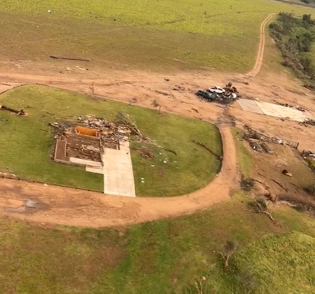
So did that one house on the north side of Matador. So wouldn't saying "Alpena didn't produce EF5 structural damage" essentially invalidate what you wrote about the Matador tornado back in March?Alpena in no way produced EF5 structural damage. That house utilized different foundation types for different rooms, and there were entire exterior walls with no anchor bolts present.
100% hit the nail on the head here. So if I understand correctly, you're basically saying that tornadoes like Alpena and Matador can be considered EF5's by your own standard even if it's impossible for them to be officially considered as such?Not even possibly. Entire walls missing anchor bolts = automatic EF5 disqualification if we’re strictly talking NWS application of the scale in its current form. Solid anchoring simply HAS to be present around the entire foundation perimeter, not just some of it, for EF5 to even be considered by the NWS. So because of that, my statement about it not producing genuine EF5 structural damage just isn’t really up for debate, even if it had “the look”.
It’s basically the Mayfield conundrum. Was that tornado an EF5? Definitely. Did Mayfield produce structural damage that truly met the modern day EF5 criteria? No.
This is exactly why the scale in its current form isn’t cutting it in terms of accuracy. Construction quality doesn’t tell the whole story, but is being used as the primary determining factor. As a result, EF4 and EF5 tornadoes are occurring, but aren’t receiving ratings that accurately reflect their true intensities (I know everyone here already knows that and I’m preaching to the choir here).
Lake Martin EF4
Member
I'm not sure, but I think that March comment was in reference to a different house than the one you're talking about. In any event, the contextual evidence seems to have been his tipping point in favor of EF5, and he compared it to Rainsville's CMU EF5 homes, where EF5 contextual evidence tipped the scales towards an EF5 rating.So did that one house on the north side of Matador. So wouldn't saying "Alpena didn't produce EF5 structural damage" essentially invalidate what you wrote about the Matador tornado back in March?
TH2002
Member
- Messages
- 4,973
- Reaction score
- 11,113
- Location
- California, United States
- Special Affiliations
- SKYWARN® Volunteer
No, definitely the same house. Here are a few other angles of it. The portion around the basement was anchor bolted, but the rest of the home sat unanchored on a mix of poured concrete and CMU foundation.I'm not sure, but I think that March comment was in reference to a different house than the one you're talking about. In any event, the contextual evidence seems to have been his tipping point in favor of EF5, and he compared it to Rainsville's CMU EF5 homes, where EF5 contextual evidence tipped the scales towards an EF5 rating.
Lake Martin EF4
Member
By the maker, you're right.No, definitely the same house. Here are a few other angles of it. The portion around the basement was anchor bolted, but the rest of the home sat unanchored on a mix of poured concrete and CMU foundation.
@buckeye05, does that Matador comment from March still hold up?
Western_KS_Wx
Member
No, definitely the same house. Here are a few other angles of it. The portion around the basement was anchor bolted, but the rest of the home sat unanchored on a mix of poured concrete and CMU foundation.
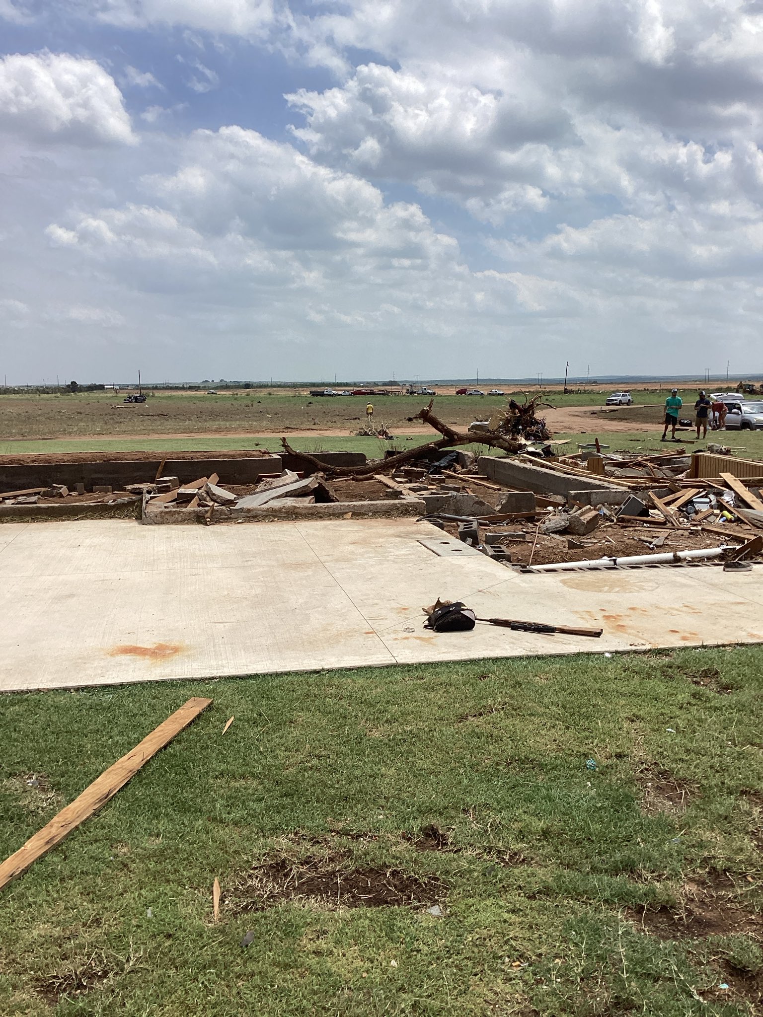
That Matador home reminds me of this residence impacted by the Parkersburg EF5 in 2008 as it passed near New Hartford. Pretty similar construction and both homes were destroyed in essentially the same fashion with extreme contextual damage nearby.


The difference is, I believe the New Hartford home was rated EF5, while the Matador home was rated EF3. While I don’t really agree with EF5 on these types of homes, EF4 is absolutely the right call. I’ve seen CMU foundation homes with little anchoring rated EF4 in multiple surveys, but for whatever reason that just didn’t apply in Matador.
AJS
Member
I don’t know if it’s just me, but I think the EF3 rating for Matador is up there for one of the worst ratings for a tornado of all time.That Matador home reminds me of this residence impacted by the Parkersburg EF5 in 2008 as it passed near New Hartford. Pretty similar construction and both homes were destroyed in essentially the same fashion with extreme contextual damage nearby.
View attachment 44212
View attachment 44213
The difference is, I believe the New Hartford home was rated EF5, while the Matador home was rated EF3. While I don’t really agree with EF5 on these types of homes, EF4 is absolutely the right call. I’ve seen CMU foundation homes with little anchoring rated EF4 in multiple surveys, but for whatever reason that just didn’t apply in Matador.