Maybe they had more detail in their paid summary, but what I've read elsewhere about the alleged start near Columbus sounded more like a guess there might have been a tornado than anything really convincing.
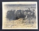
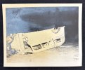
For the 1971 outbreak Tornado Talk partly used close aerial photography that was taken two days afterwards, which Grazulis wouldn't have had. Even then the path is faint or not apparent in places. That'll be partly because I mainly looked at previews and only downloaded a few full res pics - whoever at Tornado Talk wrestled with the Earth Explorer had the patience of a saint. But it also partly due to the ground conditions - cleared, a lot of bare ground, and standing water showing rain may have removed soil disturbances. The Rolling Fork tornado was only little more obvious on Sentinel. I do wonder how they determined the path width in some places and as always they're bold with the damage contours. I can see how someone might conclude differently, especially if they didn't have those aerials and had to rely on reports.
With respect to less well documented ones like the Wilson tornado (which there isn't good imagery for) I think a more conservative approach is right most times. You'd know from your examination of the Brandon tornado from the same outbreak. We even have much more recent events (Yazoo City, Hackleburg, Holly Springs) with spurious joins.
The Tornado Talk summaries (I was scouring their Facebook for photos when I wrote my original post) have some other interesting bits - both the Cullman and Trenton 4/27 tornadoes have gaps. The Trenton one is especially interesting, intense tree damage stops abruptly and then resumes initially from a different direction. Can tornadoes skip now? When I've seen authorities say they don't? Should it be considered a new tornado? Not a question likely to be answered with the available radar data or lack of footage.
I'd also be interested in seeing different parties' interpretation of the same events and data, especially from the guys who can find info where I wouldn't even know where to start. For example, the twitter poster who you included showing the gaps in the Yazoo City path has produced a reconstruction of Udall unlike any other I've seen and another showing the Charles City path as being less than ten miles. Be interesting to someone else's takes on the same events.
(do you have info about my question about Cordova and Uniontown?)