• Welcome to TalkWeather!
    We see you lurking around TalkWeather! Take the extra step and join us today to view attachments, see less ads and maybe even join the discussion.
    CLICK TO JOIN TALKWEATHER

Significant Tornado Events

Speaking of 5/31/85, I'm still trying to nail down the context behind it, but this is apparently the Barrie F4+ (or at least the back side of it) crossing Hwy 400.

Wx9JcZd.png


Reminds me very much of this photo (mirrored for comparison purposes) of the 7/20/68 La Riviere, MB F3:

e2maUpf.png


Anyway, it looks like this is the southbound lane of Hwy 400 north of the interchange, which would probably put the tornado roughly around this part of the Barrie Raceway area at the time of the photo:

HXqV7Fi.jpeg
Where did you get that photo supposedly of Barrie from? I want to check it out as I’m a bit skeptical that it is of the tornado and not just rain. Many sources claim there is only one image of Barrie which was of the tornado as it was a waterspout over Lake Simcoe. I just feel that if that is of the Barrie tornado those cars and trees would have been much more affected as highway 400 is where Barrie was at its strongest.
 
Where did you get that photo supposedly of Barrie from? I want to check it out as I’m a bit skeptical that it is of the tornado and not just rain. Many sources claim there is only one image of Barrie which was of the tornado as it was a waterspout over Lake Simcoe. I just feel that if that is of the Barrie tornado those cars and trees would have been much more affected as highway 400 is where Barrie was at its strongest.
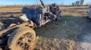
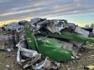
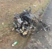
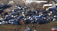
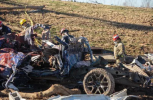
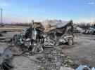
The cars and trees in the foreground are outside of the tornado's path, but the highway was very busy at the time of the tornado and several cars were rolled/lofted (which is amazing that no one died). You can see bits of debris flying, although it's hard to tell for certain if any part of the tornado itself is actually in the photo.

Anyway, it's from the booklet produced by the Barrie Banner, which it turns out includes the context that I'd missed earlier. It was taken by a man named Archie McNeil, who apparently took multiple photos. I came across his account while I was researching for my article as well but I'd never seen the actual photo(s) before.
 
Alright so now on my ever expanding plate, a question very specifically directed at @TH2002 and @Juliett Bravo Kilo, but could also apply to anyone who can access Tornado Talk's premium articles.

That whole 4/27 video dump I did yesterday sent me down a rabbit hole and eventually I decided to revisit a news coverage video from the Barnesville "EF3" that occurred overnight, which I will describe momentarily, but unfortunately I couldn't find it by searching on Youtube and the one place I know a link to it exists (the Tornado Talk article on Barnesville) now lives behind a paywall (which is BS because it was free before).

The reason this specific video is of note to me is because, at one point, it plays about 5 seconds of tornado footage that may actually be of the Barnesville tornado itself, which if true would be the only media showing the actual funnel I have ever seen and only one of 2 videos I know of showing the storm (this is the other one).

So, the question today - is anyone willing to go to the Tornado Talk article on Barnesville and link that video here? It's been driving me insane all morning and I'd like to dig it up again before I lose my mind lol


Do you recall the name of the video?
 

Okay, now I'm legitimately angry. I swear to god that at least one of those videos had tornado footage, but lo and behold, NOPE! I'm absolutely certain I saw a few seconds of footage in one of those....in fact, I'm not entirely certain it wasn't Victoria Mattox's video, which does appear to have an abrupt cut within it.

Furthermore, I'm fairly certain I even took a screencap of the footage, and it's probably somewhere on my computer. If it is, I'll probably dig it up and post it here.

EDIT: couldn't find it, but I did try to draw it from memory, and it looked something like this:
backdrop6.png
 
Last edited:
Years ago for my tornado climatology article I used a tweaked version of Rich Thompson's DPI metric to rank outbreaks and IIRC my list came out quite similar. In fact I think mine also resulted in 5/31/85 outscoring Palm Sunday, among other oddities. It's hard to draw many conclusions without knowing how they're weighting their variables, but I'm always inclined to chalk it up to the historical record being garbage. Using Grazulis' data would probably clean up a lot, although it's still not perfect and would be a pain to do.
I'd ask about the article but I see it's a decade-old project. What was the tweak though?

Thompson's formula's area based with mean path width. Makes comparing 1995 on with max width difficult, let alone post-EF scale. Both measures have arguments. Max width isn't representative and tornadoes can vary a lot even while maintaining similar intensity (like the Czech Republic tornado from a few years ago). Mean is hard to calculate accurately and requires consistency in determining where the edges are. I personally prefer maximum.

I see a section about the damage areas, raising a major problem. As Andy's paper point put, there's still no formal guidance on drawing damage contours, they're freehanded (many tornadoes never have any published). I agree with the premise that you can't consider tornadoes that did a small amount of violent damage equivalent to ones that did a lot, but there's no neat solution.

A tentative conclusion of mine is that older widths are biased low compared to newer ones. Descriptions I've read of older tornadoes make me think that estimates probably omitted at least part of what would be considered F0 damage (which can be a hefty proportion) especially in open terrain (sometimes, like Binger 1981, it's done explicitly). This especially goes for paths mapped aerially (aside from liking to map tornadoes aerially, did Fujita rate some of the Super Outbreak tornadoes from a plane?)

Most examples of stated discontinuity in old reports are tornado families, but there's a few oddities. Some reports distinguish between tornadoes 'on the ground' and at 'rooftop' or 'treetop' level. It seems some reports only considered a tornado to be "on the ground" when there was visible disturbance, many are too weak to do that, so false impressions could arise. There's also instances of tornadoes being considered wind / downburst because the tree blowdown was straight (I saw Marshall mention this once).

Getting back to where we started though, even with Palm Sunday losing an F4 and F3 by counting only April 11, looking at the combinations of ratings and paths, I can't square the circle of putting 31/5/85 over Palm Sunday.

There's one implication of this paper by Broyles et al. Data quality does matter. They're trying distinguish severe tornado outbreaks so they can figure out their ingredients and predict them better. They're looking at categories like rating and path length. Joined together paths will affect things (or require checking manually - so why not fix the problem for good?) I've seen the argument ratings don't matter. Obviously violent tornadoes being rated EF3 because of some specious excuse will affect this kind of research. Yet the predominant attitude is that data quality isn't important enough to fix obvious issues (of course the overall amount is too large to fully revise).
 
Last edited:
Sayler Park damage photos continued (rambling to hit word count):

kq9p7bW.jpeg


mTPcwQg.jpeg


XEX0f3m.jpeg


1t7BLI0.jpeg


2m9qkht.jpeg


1fjRDMX.jpeg


hmvkPeM.jpeg


Van thrown into the river and fished out later:

AZtQdP2.jpeg
Yeah, this would definitely not be rated EF5 today. Based on these pictures, I could even, and I hate to say this, see them lowballing it down to EF3...

But it probably deserved F5 by the standards of that time. The windrowing is impressive and it obviously swept away no few homes.
 
Mayfield Consumer Products vehicle damage, almost all parked cars in the parking lot of the building were totaled and there were dozens of cases of incredibly mangled vehicles, including ones fused with farming equipment (image 5) and ones with expelled engines (images 4 & 6) probably one of the most impressive vehicular feats in the time since Moore, there's a ton of media of these vehicles online, strangely enough one of the best sources is from a car repair channel looking through a scrap lot of vehicles from the tornado -
 

Attachments

  • Screenshot_20250430-012244.png
    Screenshot_20250430-012244.png
    1 MB · Views: 0
  • Screenshot_20250430-012324.png
    Screenshot_20250430-012324.png
    813.4 KB · Views: 0
  • FB_IMG_1743882721486-1.jpg
    FB_IMG_1743882721486-1.jpg
    53.9 KB · Views: 0
  • Screenshot_20250430-012708.png
    Screenshot_20250430-012708.png
    1.4 MB · Views: 0
  • mmexport1641753534399-2.jpg
    mmexport1641753534399-2.jpg
    314.4 KB · Views: 0
  • Screenshot_20250405-155614-1.png
    Screenshot_20250405-155614-1.png
    747.7 KB · Views: 0
  • Screenshot_20250328-024514.png
    Screenshot_20250328-024514.png
    1.1 MB · Views: 0
  • Screenshot_20250430-014304.png
    Screenshot_20250430-014304.png
    1.3 MB · Views: 0
  • Screenshot_20250430-014331.png
    Screenshot_20250430-014331.png
    1 MB · Views: 0
  • 2F6B30B7-AC3D-4C0F-B74B-8B03645C8162-2.jpg
    2F6B30B7-AC3D-4C0F-B74B-8B03645C8162-2.jpg
    223.9 KB · Views: 0
It's just occurred to me looking at old storm reports (specifically the May 8 1965 outbreak) that the reason so many tornadoes have '10 yards' width is it's a default value. All the Nebraska tornadoes are reported as being 'narrow' (I've also seen it used for ones with no stated path width). Presumably this was done when the offical digital database was constructed. In a similar manner, 0.1 miles is used as a default path length. As for how some of the locations were determined, that's mysterious.

Also apparently in the fifties (June 7 to be exact) the Weather Bureau was a bit looser with their terminology:
Screen Shot 2025-04-30 at 8.58.46 pm.png
 
Last edited:
Mayfield Consumer Products vehicle damage, almost all parked cars in the parking lot of the building were totaled and there were dozens of cases of incredibly mangled vehicles, including ones fused with farming equipment (image 5) and ones with expelled engines (images 4 & 6) probably one of the most impressive vehicular feats in the time since Moore, there's a ton of media of these vehicles online, strangely enough one of the best sources is from a car repair channel looking through a scrap lot of vehicles from the tornado -

Dear god; that vehicle damage is on par with Matador (2023); that is no easy feat to do.
 
  • Like
Reactions: AJS
Mayfield Consumer Products vehicle damage, almost all parked cars in the parking lot of the building were totaled and there were dozens of cases of incredibly mangled vehicles, including ones fused with farming equipment (image 5) and ones with expelled engines (images 4 & 6) probably one of the most impressive vehicular feats in the time since Moore, there's a ton of media of these vehicles online, strangely enough one of the best sources is from a car repair channel looking through a scrap lot of vehicles from the tornado -

I actually have a feeling the tornado may have reached EF5 strength in this area of Mayfield. The contextual damage was pretty extreme. Significant debarking of trees, noticeable grass scouring, and that vehicle damage is nothing but extreme. The tornado also swept away numerous homes in this area with some pronounced rowing. I’ll need to look for the image I have of that, but it’s extreme.
 
Back
Top