
Juliett Bravo Kilo
Member
Here you go:Everything about it is absurd. Even OFFICIALLY, it had 18 violent tornadoes. And you're right, the proportion of violent tornadoes to tornadoes overall is insane.
The jet streak was BLASTING away and all of these storms were faster than I ever drive, some apparently as fast as 75 MPH.
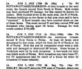
I'm STILL trying to find information and pictures on the Williams Bay-Lake Como, WI tornado that day. I know, I distinctly remember someone in this thread posting extremely impressive damage from an obscure "F1" in southern WI. I found these in a local historical society picture but while this indicates the possibility of something greater than F1, it isn't clear.
View attachment 39661
View attachment 39662
Significant Tornado Events
Damage from the 1883 Rochester tornado likely the strongest tornado in MN history, only tied with the 1919 Fergus Falls tornado.


") However, they held off on the high risk initially due to concerns over lesser storm coverage, but by the time of the first Day-1 outlook it was clear the bigger issue was going to be outflow wrecking the thermodynamics in parts of the warm sector, and potential for destructive storm interactions which did indeed end up significantly limiting the ceiling of the event. As one chaser in the Stormtrack Discord put it: "One left split. I have never before seen a tornado outbreak Atmospheric Anti-Climax by one left split." In keeping with the general theme of last year in the Southern Plains, the most significant tornadoes came after dark.
However, they held off on the high risk initially due to concerns over lesser storm coverage, but by the time of the first Day-1 outlook it was clear the bigger issue was going to be outflow wrecking the thermodynamics in parts of the warm sector, and potential for destructive storm interactions which did indeed end up significantly limiting the ceiling of the event. As one chaser in the Stormtrack Discord put it: "One left split. I have never before seen a tornado outbreak Atmospheric Anti-Climax by one left split." In keeping with the general theme of last year in the Southern Plains, the most significant tornadoes came after dark.