• Welcome to TalkWeather!
    We see you lurking around TalkWeather! Take the extra step and join us today to view attachments, see less ads and maybe even join the discussion.
    CLICK TO JOIN TALKWEATHER

Significant Tornado Events

I have, I still would give the edge to Andover though. Just an opinion, but Andover in that video has about as violent of rotation you will ever see.
So, the previous twitter link has gone down so I re-uploaded it as an unlisted YouTube video as private mp4s aren't accepted as uploads here; the Pampa rotation. The person had to compress and zoom in a bit so the stability is a bit off but you can really see the insane drillbit motions on this thing. Also, note how quickly the pickups go in and out of the funnel:

 
The stuff about the sledgehammer with Smithville...that doesn't explain the ground scouring with that thing. The fact it managed to do that kind of ground scouring while moving along that quickly is incredible.
Slow and fast movement....yeah, this is an interesting issue. Bowdle hardly did any damage while moving slower than Jarrell yet Jarrell did arguably the most violent tornado damage ever photographed.
That said, I do wonder about Greensburg and Trousdale while they were over open country, so I get where you're coming from. I'd love to have photographs of the areas they were over before they hit towns or farms, to see how much ground scouring they did over open country.
Not to mention vehicles thrown 3/4 a mile and reduced to nothing. Extreme debris granulation and extraordinary tree damage. A tornado moving 60-70 mph had the strength to pull out plumbing fixtures from the foundation. Just mind boggling.
 
Not to mention vehicles thrown 3/4 a mile and reduced to nothing. Extreme debris granulation and extraordinary tree damage. A tornado moving 60-70 mph had the strength to pull out plumbing fixtures from the foundation. Just mind boggling.
Indeed, it's easily among the most violent ever documented.
 
Greensburg would definitely, Marshal has stated as such. Rainsville and Philadelphia I agree with you there, neither hit homes that would qualify for an EF5 rating.
I copied this from extremeplanet: This is an instance of damage from the Rainsville tornado.

View of 1608 Lingerfelt Road, where an NWS survey team documented some of the most intense tornado damage ever recorded. The owners of the large, two-story brick home survived with several neighbors in an underground storm shelter. The tornado breeched the top of the storm cave, partially exposing the people huddled inside. An interesting feature of the damage was the sharp boundary (marked by scoured grass) separating the EF5 damage from standing trees a short distance to the east. Trees immediately south of the home were blown over but not debarked, whereas vegetation across the street was stripped bare. Visible grass and pavement scouring a few yards north of the home hints at the presence of a powerful wind feature that descended from the tornado and made contact with the ground after passing over the foundation.

. An NWS surveyfound that an 800lb anchored safe had been ripped from the home’s foundation and thrown 200 yards to the northeast. The door to the safe, which had been closed, was torn open and completely off. A large concrete porch weighing thousands of pounds was shattered and blown away from the destroyed home
Yes, but a picture of that home does not match the descriptions; it was poorly built CMU, and the storm shelter only had the outside door and ground around it disturbed. No scouring or shredding in front of vegetation.1735473658861.png
 

Attachments

  • 223232444.png
    223232444.png
    703.4 KB · Views: 0
Yes, but a picture of that home does not match the descriptions; it was poorly built CMU, and the storm shelter only had the outside door and ground around it disturbed. No scouring or shredding in front of vegetation.View attachment 32409
Rainsville did produce some remarkable wind-rowing, vegetation damage, and granulation in areas past Lingerfelt Road that I think clearly points to an EF5 tornado, but I will agree the construction quality in most homes was pretty questionable. There were numerous homes and other structures wiped clean, but I haven’t really seen many photos of areas outside of Rainsville so it’s tough to say if true EF5 damage occurred.
 
Rainsville did produce some remarkable wind-rowing, vegetation damage, and granulation in areas past Lingerfelt Road that I think clearly points to an EF5 tornado, but I will agree the construction quality in most homes was pretty questionable. There were numerous homes and other structures wiped clean, but I haven’t really seen many photos of areas outside of Rainsville so it’s tough to say if true EF5 damage occurred.
I believe there was an area of true EF5 damage on Skaggs Road - apparently a (supposedly) well-built masonry home had a stone pillar in its basement that was almost completely uprooted out of the floor, or something like that.

I think Rainsville was a great application of the EF scale because even if it didn’t do any textbook EF5 damage it still was undeniably of that intensity and contextuals showed it, which was reflected in damage surveys.
 
Yes, but a picture of that home does not match the descriptions; it was poorly built CMU, and the storm shelter only had the outside door and ground around it disturbed. No scouring or shredding in front of vegetation.View attachment 32409
From what I read there was grass scouring, pavement removal and vegetation stripped bare. I agree the house doesn’t look very well built. When you look at it front the context of Philadelphia, MS it failed to produce the 3 foot trenches.
 
Rainsville did produce some remarkable wind-rowing, vegetation damage, and granulation in areas past Lingerfelt Road that I think clearly points to an EF5 tornado, but I will agree the construction quality in most homes was pretty questionable. There were numerous homes and other structures wiped clean, but I haven’t really seen many photos of areas outside of Rainsville so it’s tough to say if true EF5 damage occurred.
Oh agreed its just this home appears questionable.
 
I appreciate it man! It’s tough to say where it peaked, as it was pretty steady-state and very likely maintained EF5 intensity from just east of Highway 183 to the north side of Greensburg, a distance of 10 miles.

I will say however, the ground scouring appeared to be most significant along Highway 183 and that was probably where the initial peak occurred. There was also some extreme damage to two gas compression stations along the highway, I’m going to research more about these stations but the damage there was very upper-echelon. There was also several reports of the ground being gouged out and trenches being dug in the soil, which I initially believed were caused by debris impacts but I’m almost positive that was scouring done by the tornado.

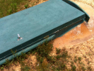
Here’s an aerial of some of the scouring/gouging in a field about a mile or so south of Greensburg. Much of these depressions/gouges in the field were several inches deep and down to the bare soil in some spots, but were most extreme along Highway 183.
View attachment 31908

While the tornado likely maintained EF5 intensity all the way through Greensburg, I believe the most extreme damage occurred near the lake. The aerials from there show some absolutely incredible debris granulation and tree damage.
These gouges are very unique looking. I wonder if it’s caused by extreme suction from the sub-vortices within the tornado? This sort of reminds me of the 2021 damage outside of NE Arkansas. Has areas of deep gouges. Thank you for sharing. So fascinating!
 
These gouges are very unique looking. I wonder if it’s caused by extreme suction from the sub-vortices within the tornado? This sort of reminds me of the 2021 damage outside of NE Arkansas. Has areas of deep gouges. Thank you for sharing. So fascinating!
It is undoubtedly from suction vortices yes, and extremely violent one’s at that. However, I have yet to see anything as unusual and erratic as the vortices within the Greensburg tornado. If you look closely elsewhere in the field around the deep gouges, there’s other marks from separate extreme wind features that are legit only at max a couple feet in width. The tornado’s core consisted of this weird carousel of suction vortices that orbited and intertwined around one another without a defined centerline, except for near the lake in north Greensburg where the structure of the vortex changed. Really odd and fascinating stuff.
 
It is undoubtedly from suction vortices yes, and extremely violent one’s at that. However, I have yet to see anything as unusual and erratic as the vortices within the Greensburg tornado. If you look closely elsewhere in the field around the deep gouges, there’s other marks from separate extreme wind features that are legit only at max a couple feet in width. The tornado’s core consisted of this weird carousel of suction vortices that orbited and intertwined around one another without a defined centerline, except for near the lake in north Greensburg where the structure of the vortex changed. Really odd and fascinating stuff.
What do you think about the tornado that followed the Greensburg tornado? I have read it might have been even stronger. I travel some of those areas and you would be amazed how desolate the area is in terms of population.
 
What do you think about the tornado that followed the Greensburg tornado? I have read it might have been even stronger. I travel some of those areas and you would be amazed how desolate the area is in terms of population.
Trousdale and Hopewell were absolutely monstrous and violent tornadoes, that like you said traversed very rural areas thankfully. Trousdale was like Greensburg in that it had some unusual vortex characteristics resulting in erratic damage, but it was every bit of EF5 strength. It’s also quite possible the thing was 3 miles wide. Hopewell as well was pretty obviously violent and produced some absolutely phenomenal vehicle and vegetation damage indicative of EF5 intensity in my opinion. Tough to say if either of these tornadoes were more powerful than Greensburg, but a few of the surveyors that went and saw the damage on the ground with Trousdale and the other meteorologists at NWS Dodge City all seem to come to the conclusion that it is quite likely Trousdale was more intense than Greensburg.

Also, I’m not really sure of who was responsible for the ratings at NWS Dodge City, but one of the surveyors who surveyed all 4 of the tornadoes and (I think) had the final say in those ratings made some interesting claims. He said most of the damage in Greensburg was indicative of an EF3 or low-end EF4 tornado, which is a bit absurd, and claimed the highschool and apparently the water tower was one of the things that pushed them ‘over the edge’ for an EF5 rating. If he did have the final say in the ratings with the other tornadoes, then I think it’s pretty clear why they weren’t rated higher than EF3 with that kind of criteria being used. Also never really got clarity on the potential EF4 damage indicator from Hopewell either, so it really is a mystery.
Did Marshal have anything on Trousdale, Hopewell or Macksville? I am aware that they did destroy farms, I just recall seeing once that one of those tornadoes was said to be rated EF4 on some page or something, but am blanking on the source.
 
Trousdale and Hopewell were absolutely monstrous and violent tornadoes, that like you said traversed very rural areas thankfully. Trousdale was like Greensburg in that it had some unusual vortex characteristics resulting in erratic damage, but it was every bit of EF5 strength. It’s also quite possible the thing was 3 miles wide. Hopewell as well was pretty obviously violent and produced some absolutely phenomenal vehicle and vegetation damage indicative of EF5 intensity in my opinion. Tough to say if either of these tornadoes were more powerful than Greensburg, but a few of the surveyors that went and saw the damage on the ground with Trousdale and the other meteorologists at NWS Dodge City all seem to come to the conclusion that it is quite likely Trousdale was more intense than Greensburg.

Also, I’m not really sure of who was responsible for the ratings at NWS Dodge City, but one of the surveyors who surveyed all 4 of the tornadoes and (I think) had the final say in those ratings made some interesting claims. He said most of the damage in Greensburg was indicative of an EF3 or low-end EF4 tornado, which is a bit absurd, and claimed the highschool and apparently the water tower was one of the things that pushed them ‘over the edge’ for an EF5 rating. If he did have the final say in the ratings with the other tornadoes, then I think it’s pretty clear why they weren’t rated higher than EF3 with that kind of criteria being used. Also never really got clarity on the potential EF4 damage indicator from Hopewell either, so it really is a mystery.
I will be honest. I was always under the impression that Greensburg had minimal EF-5 damage. I’m glad you have done the research and proved otherwise. I was at the Joplin aftermath and saw damage indicative of EF-5 all around me but I still feel that Joplin also doesn’t get the credit for just how powerful it really was. Back to Greensburg I remember watching the KAKE video on YouTube of the supercell and it was incredible to see the radar images and gait to gait shear. Seemed to be traveling almost due north as well. Do you have any other photos of the gouges in the fields?
 
Did Marshal have anything on Trousdale, Hopewell or Macksville? I am aware that they did destroy farms, I just recall seeing once that one of those tornadoes was said to be rated EF4 on some page or something, but am blanking on the source.
Here is the area I was referring to. The gouges do look different but certain areas had random deep gouges without any debris around.

 
Here is the area I was referring to. The gouges do look different but certain areas had random deep gouges without any debris around.


There have been many conversations in the past about this specific example of gouge scouring, I believe we were talking about this versus Philadelphia 2011 and other examples of it. I’m of the opinion that this scouring from the Western Kentucky storm isn’t actually as impressive as regular grass scouring, Philadelphia/Smithville, or the scouring from later in this same storm’s path. I can list the reasons if you’d like me to
 
Back
Top