
So has anyone got some photos of the EF5 rated homes in Parkersburg besides the one with that partly collapsed basement wall? Also any general images of extreme damage feats from Parkersburg would be appreciated since this tornado seems more forgotten than many of the others. (Also seems to be much less documentation of it image wise).
Navigation
Install the app
How to install the app on iOS
Follow along with the video below to see how to install our site as a web app on your home screen.
Note: This feature may not be available in some browsers.
More options
-
Welcome to TalkWeather! We see you lurking around TalkWeather! Take the extra step and join us today to view attachments, see less ads and maybe even join the discussion. CLICK TO JOIN TALKWEATHER
You are using an out of date browser. It may not display this or other websites correctly.
You should upgrade or use an alternative browser.
You should upgrade or use an alternative browser.
Significant Tornado Events
- Thread starter locomusic01
- Start date
Tanner
Member
Wow, definitely more violent than I always thought, and certainly higher than low-end EF4This isn’t really related to recent topics from the thread but I’ve always been curious about damage photos from the Keota Iowa tornado from the March 31, 2023 outbreak. I’m sure we’ve all seen the videos taken of the thing — no doubt one of the meanest and most violent looking tornadoes filmed in recent memory.
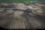
Appearance wise aside, it’s been awfully difficult to find many photos or information on its aftermath. I did manage to find some photos, all taken near Keota more towards the beginning of the path.
View attachment 29447
View attachment 29448
View attachment 29449
This was the site where EF4 damage was found to a farmstead. The home was wiped clean off its foundation, and a car along with some farm implements were launched ~400 yards into a field.
View attachment 29450
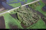
An aerial of the destroyed farm, some very impressive cycloidal ground scouring is clearly visible here. This level of cycloidal scouring is very reminiscent of that left behind by the Rochelle and Washington Illinois EF4’s.
View attachment 29451
Not entirely sure what this hunk of metal is, but it was in a field near the farm that sustained EF4 damage. I think this may be the frame of some sort of farm vehicle or implement, whatever it was is just completely mangled. Some impressive scouring is also visible nearby.
View attachment 29452View attachment 29453View attachment 29454View attachment 29455
Some additional damage elsewhere near Keota.
Sawmaster
Member
It's not really forgotten here in the US, it's just that few videos exist of it and that's what makes tornadoes known more widely. Only a small handful of videos and I've seen few pics- but someone else may have something.So has anyone got some photos of the EF5 rated homes in Parkersburg besides the one with that partly collapsed basement wall? Also any general images of extreme damage feats from Parkersburg would be appreciated since this tornado seems more forgotten than many of the others. (Also seems to be much less documentation of it image wise).
The video of the white house across from the bank disintegrating is quite popular and known because of the clarity. It's one of my top 5 picks.
Western_KS_Wx
Member
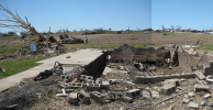
So has anyone got some photos of the EF5 rated homes in Parkersburg besides the one with that partly collapsed basement wall? Also any general images of extreme damage feats from Parkersburg would be appreciated since this tornado seems more forgotten than many of the others. (Also seems to be much less documentation of it image wise).
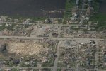
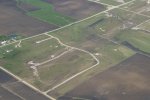
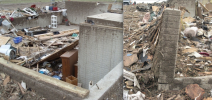
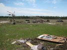
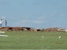
Here’s damage located in and around Parkersburg:


Damage on the eastern side of town and the golf course where it likely peaked in intensity:


Multiple houses swept completely away in quite a large swath as well. Very impressive wind rowing and scouring is visible as well.
Western_KS_Wx
Member
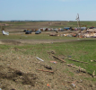
Here’s some from New Hartford:


Parkersburg was an absolute monster, no doubt one of the most violent tornadoes in modern history. No shortage of incredible damage feats from this tornado either.
Parkersburg was an absolute monster, no doubt one of the most violent tornadoes in modern history. No shortage of incredible damage feats from this tornado either.
AngelAndHisWx
Member


I found (on eBay of all places) eight color slides of damage in Rutland MA after the 1953 Worcester F4, taken only hours after. Presented here are four of the more interesting ones. These slides are very dirty, but I don’t have the means to clean them at the moment. Nonetheless, apparently color damage photos from this era are very rare, so I wanted to share.
Thanks for these, would you say more violent than Greensburg? Considering how much you know about Greensburg.Here’s some from New Hartford:
View attachment 29466
View attachment 29468
View attachment 29467View attachment 29469View attachment 29470View attachment 29471View attachment 29472View attachment 29473
Parkersburg was an absolute monster, no doubt one of the most violent tornadoes in modern history. No shortage of incredible damage feats from this tornado either.
Last edited:
CheeselandSkies
Member
What was Iowa's last violent tornado prior to Parkersburg? They had one in 2008, 2010, 2011 and 2013, then none until Winterset 2022 and at least one every year since (two this year depending on how you count, although Elkhorn-Modale technically didn't do EF4 damage in Iowa). I think I remarked after Keota last year that they had a remarkably good streak going of the higher-end tornadoes missing direct hits on towns/cities, but of course that ended this year with Minden and Greenfield.
Aaron Rider
Member
It had been a little while. Before Parkersburg, the last violent ones were a couple of F4s in April 1999.What was Iowa's last violent tornado prior to Parkersburg? They had one in 2008, 2010, 2011 and 2013, then none until Winterset 2022 and at least one every year since (two this year depending on how you count, although Elkhorn-Modale technically didn't do EF4 damage in Iowa). I think I remarked after Keota last year that they had a remarkably good streak going of the higher-end tornadoes missing direct hits on towns/cities, but of course that ended this year with Minden and Greenfield.
The period of like 80 through 2007 was somewhat quiet in Iowa.

April 8, 1999 | Southwest Iowa F-4 Tornadoes
On April 8, 1999 nearly a dozen tornadoes touched down in eastern Nebraska into southern Iowa, where two F-4 tornadoes occurred
 www.3newsnow.com
Western_KS_Wx
Member
I think I’d give Parkersburg a slight edge over Greensburg, due in part to the sheer number and consistency of homes and structures swept clean. I do think they’re pretty equal in intensity and caused similar vegetation and contextual damage, but I would say Parkersburg was probably a notch above Greensburg.Thanks for these, would you say more violent than Greensburg? Considering how much you know about Greensburg.
CheeselandSkies
Member
It had been a little while. Before Parkersburg, the last violent ones were a couple of F4s in April 1999.
The period of like 80 through 2007 was somewhat quiet in Iowa.
April 8, 1999 | Southwest Iowa F-4 Tornadoes
On April 8, 1999 nearly a dozen tornadoes touched down in eastern Nebraska into southern Iowa, where two F-4 tornadoes occurred
That area between US-34 and IA-92, especially in the south-central to southwest part of the state, would seem to be a definite hot spot.
Aaron Rider
Member
I think so.That area between US-34 and IA-92, especially in the south-central to southwest part of the state, would seem to be a definite hot spot.
Here's every Iowa violent tornado

Aaron Rider
Member
And here's the same since 1974

Aaron Rider
Member
Just because I was curious, here's Missouri since 1974. Interesting. Missouri seems to be part of 3 different tornado alleys: the Iowa and Nebraska one, a little one around the old lead mining belt, and the greater Ohio Valley

Juliett Bravo Kilo
Member
Here’s damage located in and around Parkersburg:
View attachment 29456
View attachment 29457View attachment 29458View attachment 29459
View attachment 29460
View attachment 29464
Damage on the eastern side of town and the golf course where it likely peaked in intensity:
View attachment 29465
View attachment 29461
View attachment 29462
View attachment 29463
Multiple houses swept completely away in quite a large swath as well. Very impressive wind rowing and scouring is visible as well.
More pics from Parkersburg:
Attachments
-
 ACPVFK6.jpeg234.8 KB · Views: 0
 -
 eFUXdOs.jpeg315 KB · Views: 0
 -
 OidMbRz.jpeg191.7 KB · Views: 0
 -
 Park_2.png635.7 KB · Views: 0
 -
 Park_3.png1.2 MB · Views: 0
 -
 Park_6.jpg148.3 KB · Views: 0
 -
 Park_4.png1.4 MB · Views: 0
 -
 Park_7.jpg180.5 KB · Views: 0
 -
 Park_10.JPG311.8 KB · Views: 0
 -
 Park_11.png575.3 KB · Views: 0
Juliett Bravo Kilo
Member
Last 5


 :
:
:TH2002
Member
- Messages
- 4,973
- Reaction score
- 11,113
- Location
- California, United States
- Special Affiliations
- SKYWARN® Volunteer
I have 10 videos in my Parkersburg collection, so there's actually no shortage of footage from the event. Especially considering 2008 was a time before everyone carried around HD smartphone cameras with them every waking minute, and high speed internet had only been widespread for a few years so the idea of sharing amateur tornado footage was still relatively new to a number of folks.It's not really forgotten here in the US, it's just that few videos exist of it and that's what makes tornadoes known more widely. Only a small handful of videos and I've seen few pics- but someone else may have something.
The video of the white house across from the bank disintegrating is quite popular and known because of the clarity. It's one of my top 5 picks.
Also, shout-out to the Iowa Mesonet. Tons and tons of resources on Iowa tornado events from 2002-2013 (and 2023) including photos, videos, damage and radar imagery. Some of the clips in particular I haven't seen elsewhere, so I highly recommend checking it out.
edit: fixed link
Last edited:
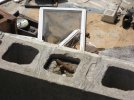
So I was wondering, has anyone got any actual, clear ground images of that very large and reportedly well constructed home in Oak Grove from the 2011 EF5? Also there was apparently a corvette that was thrown 641 yards and badly mangled at that property? Anybody got any photos of this as it was here where the NWS said that the Hackleburg tornado reached maximum intensity. Also I can't help but notice the lack of genuine images of EF5 damage from Hackleburg. I think I have seen one home in Hackleburg with anchor bolts but that is it. (Not saying it does not deserve EF5, it most certainly did).
slenker
Member
I believe these two pictures are the same home. This was an “exceptionally well built” brick home that was three stories(?) iirc. Strangely, the tornado wasn’t scouring the ground nearly as much as it was in Hackleburg or Phil Campbell within Oak Grove, so the tornado either reached maximum intensity in Oak Grove and the soil is stronger there, or the tornado was at maximum intensity somewhere before/after and it didn’t hit anything well built enough to justify it being at maximum intensity at those locations. I also understand that ground/grass scouring is a very strange phenomenon and isn’t consistent in violent tornadoes either.So I was wondering, has anyone got any actual, clear ground images of that very large and reportedly well constructed home in Oak Grove from the 2011 EF5? Also there was apparently a corvette that was thrown 641 yards and badly mangled at that property? Anybody got any photos of this as it was here where the NWS said that the Hackleburg tornado reached maximum intensity. Also I can't help but notice the lack of genuine images of EF5 damage from Hackleburg. I think I have seen one home in Hackleburg with anchor bolts but that is it. (Not saying it does not deserve EF5, it most certainly did).
Attachments

joshoctober16
Member
i think base on stuff ive seen... that the "people lost their lives, its just a rating" could by by accident be bullying others to stop talking about the rating , thus making the ratings more inaccurate however.... ive seen studies now that... because the EF scale is so broken and they under rate stuff so much that they started to use EF1 tornadoes as EF2 for areas that are more open field (classic tornado alley) they state there doing this because tornadoes could likely be stronger as they didn't hit anything... yes ... i agree for most... but some of them are likely still just EF1 and this small data set could mess up the data some more thus making models more inaccurate and or making futures studies as more junk for the future.... causing warning lead time and false alarm to go up... thus killing more people.....The bottom line feels like this: There needs to be a point where they can very obviously say that contextuals need to be taken into account. It’s simply not accurate to call Matador an EF3, not even close. The argument that people say where “people lost their lives, it’s just a rating” is understandable but inherently flawed because scientific accuracy still matters too, for the sake of the future.
so in a nutshell the "its just a rating" might be true for the tornado that happen at that moment but might cause more death for future because we are not rating them correctly.
if some one can find that study or paper that are starting to make the classic tornado alley tornadoes that are rated only EF1 as EF2 just post a link for what i mean.