• Welcome to TalkWeather!
    We see you lurking around TalkWeather! Take the extra step and join us today to view attachments, see less ads and maybe even join the discussion.
    CLICK TO JOIN TALKWEATHER

Significant Tornado Events

There are a handful of photos, some of which I don't think I've seen anywhere else. If I have time and can remember I'll take some screenshots later. Not as much as I was hoping when I bought it tbh, but nice to see some photos from some more poorly documented areas.


The Wayback Machine has it, but it looks like it didn't archive the video. No idea what photos may've been in it.


No, I don't have any documentation for them and haven't really had time to do a deep dive and see if I can glean any more info.


Not entirely sure what you're asking. Is there something specific you're looking for?
Can you (or anyone else) identify where in the path this image was taken?1720903844388.jpeg
 
Totally random, but I think I've solved the mystery of the elusive 2/8/1978 SoCal F3 tornado.

For one, the location visible on the Tornado Archive (from the NCEI database) is completely wrong. An error in the NCEI entry transposes the location to the middle of nowhere in the Colorado Desert, when the event actually occurred in Huntington Beach. There, the storm demolished a trailer park, resulting in six injuries and $3 million worth of damage. In 2005, the event was re-analyzed as an F2 tornado by a former NWS Los Angeles meteorologist.

Also, the date of February 8 comes from the fact that the tornado start times in the official NCEI entries are listed in the UTC time code. The tornado happened on February 9 local time.
I've pointed out issues with locations in the official database before, but that takes the cake.
 
Here is my research on what I believe to be the most intense (non-pyrocumulonimbus) tornadoes recorded in California:

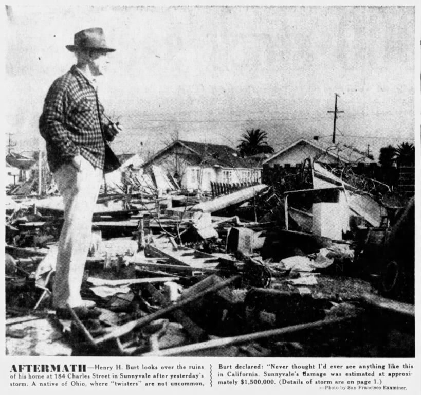
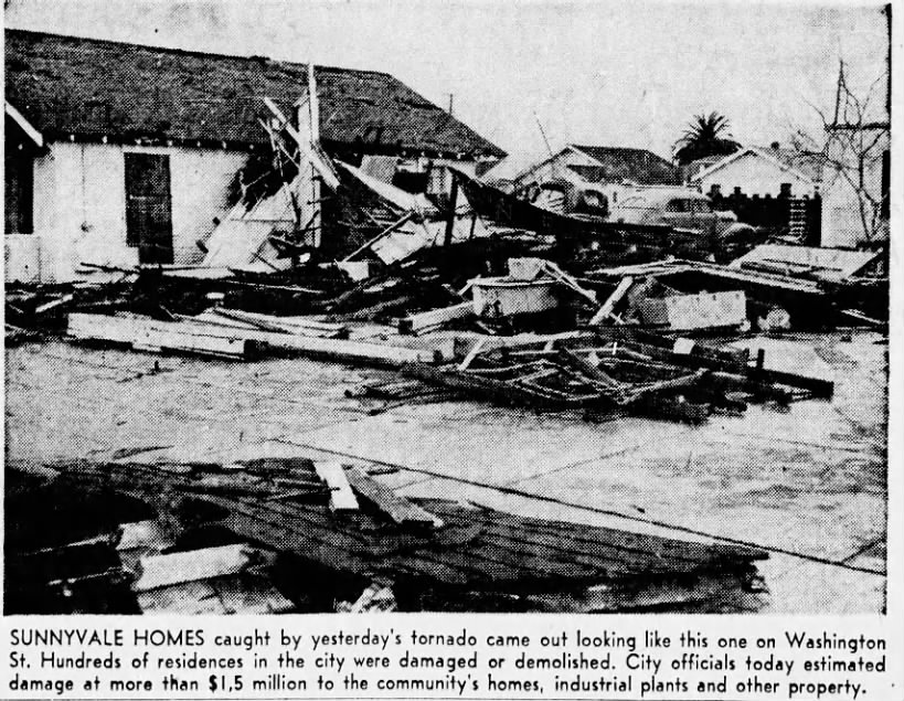
In Northern California, the 1/11/1951 Sunnyvale F2 is easily the strongest candidate for a low-end F3 rating. The storm first touched down in Loyola, slowly intensifying and doing moderate damage as it moved northeast into Sunnyvale. Continuing to intensify, the storm did its first major damage at the Southern Pacific railroad yard, ripping the roofs from the depot and bus station. A 32-ton crane at this location was lifted from the tracks and toppled into a parking lot. Now a half mile wide, the twister proceeded to damage over 250 homes in Sunnyvale, with around thirty being completely unroofed. A dozen others were dislodged from their foundations and displaced 10-15 feet, and a few poorly constructed homes were completely leveled. Six one unit apartments were reportedly "demolished". At the Westinghouse Electric Company, a 400x200 section of (tin?) roofing was ripped away and parts of a machine shop collapsed, with some walls blown inward and others crushing parked cars. A 10-ton earth-moving crane at the Woolridge Manufacturing Company was picked up and displaced 100 feet, coming to rest on its side. The tornado ultimately left 30 injuries in its wake, tying the storm with the 1983 Los Angeles tornado as the most injurious in California history. Sunnyvale was declared a federal disaster area and the Red Cross was called in to assist in reconstruction efforts.
img

img

img

img

VTD19510115.1.7-4236-1305-1593-1809-398w.jpg

Meanwhile, I have uncovered two tornadoes in Southern California that I think are genuine candidates for an F3 rating:

This first obscure tornado was brought to my attention by @MNTornadoGuy. It is not documented in any official database or Grazulis' Significant Tornadoes, and two August 1927 issues of the Calexico Chronicle are the only records of its existence. On August 28, 1927, this brief but destructive tornado struck two homes 14 miles northeast of Brawley. One home with three occupants was twisted off its foundation, displaced 150 feet and collapsed; only the roof remained relatively intact on a pile of rubble. Of the three occupants, two were killed outright and one was severely injured. Another reportedly "large and well built" home a quarter mile distant was also destroyed. Assuming the newspaper report is accurate, the storm's nature can be established with high probability, as only a tornado could have lifted an entire site-built home off its foundation and deposit the remains 150 feet away.

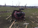
The other is officially rated F2, the September 7, 1982 Landers/Joshua Tree tornado. Reportedly, a five-room home on Post Road was completely obliterated and swept from its concrete slab foundation, with debris blown downwind. A water heater was ripped from the slab and found 100 feet away. Two small cabins were also completely destroyed, and two other homes sustained major damage. Two people were injured in a home that had half of its roof torn off and some of its walls blown inward, with a motorhome in the driveway being completely destroyed. At the same property, the tornado reportedly sucked most of the water out of a swimming pool. Trying to scrape up more damage photos:
SBS19820908.1.1-204-1752-2633-1605-658w.jpg

Some other notable events from both NorCal and SoCal:
On the same day as the Sunnyvale event, another strong tornado struck the Christensen Ranch in Two Rock. A poorly constructed two story home collapsed onto its sleeping occupants, who were fortunately not seriously injured. Nearby, a newly constructed ranch home escaped a direct hit, but nonetheless lost windows and roof tiles. Trees were denuded and farm outbuildings were completely destroyed. This event is not documented in the NCEI database or Significant Tornadoes, but TornadoTalk gave it an F2 rating, which I agree with.
img

img


On July 15, 1911, a probable tornado struck El Centro. The storm tore directly through the town's central business district, killing two people and injuring at least six others (minor injuries were not reported). A clay tile restaurant had its roof torn off and several walls collapsed, with one fatality occurring there (the other victim was killed in the open by flying debris). A tile from the restaurant was found one block away. Nearby lumber and cement companies were completely destroyed, their sheds and offices demolished. Two corrugated iron warehouses and a church were leveled, while homes and other businesses were unroofed. One of the warehouses, the Hamilton Supply Company wholesale building, was reportedly the largest structure in El Centro at the time. The walls and roof were lifted and "torn into strips", with the remains being 'hurled through the air like paper'. The church was left "as if some mighty power had crushed it from above as if it were a mere paper structure", with timbers scattered everywhere. Outbuildings were destroyed as well, and debris from destroyed structures was reportedly strewn over two blocks away (one newspaper stated "hundreds of yards"). In just a few minutes, $30,000 worth of damage was left in the tornado's wake. The event was extensively covered in newspapers of the time, but I couldn't find any damage photos unfortunately. Still, based on descriptions of the damage, the tornado may have been an F2 or a low-end F3.

Still researching this next event, but a probable tornado (that was part of a larger storm system) struck Lucerne Valley on January 27, 1916. A schoolhouse was unroofed, subsequently caught fire and burned. Homes were "blown down", with debris "blown for miles across the desert". A woman was killed by flying debris.
 
Here’s a collage of some images I managed to dig up from one of my favorite tornadoes and outbreaks to research, the May 24, 2011 El Reno EF5 tornado. These are all in the Calumet-Interstate 40 area where the tornado first peaked, and Doppler on Wheels recorded winds in excess of 290mph. Easily some of the most extreme damage ever documented. Going to post another gallery of damage at the Cactus 117 oil rig, damage there is absolutely unreal and some of the images have likely not been seen before.


Just wanted to let you know some of the locations for these images are incorrect. For instance here is a home near US-81 not the I-40. Otherwise a fantastic collection of images and I am curious if you have any more?


1721166118570.png
 
Hello, some may know me as Ivanovo man, haven't done much on that project recently but today, after all the craziness in the Chicago metro last night I was just quickly making sure (when discussing tornadoes in Chicago) that the Plainfield, IL F5 from 1990 was the last violent tornado in the Chicago metro (excluding Rochelle which barely entered the metro at a non ef4+ intensity) and when I quickly checked the 1991 Lemont, IL F3 I found like the only video showing the worst damage, this is the only research I kind of did so there probably is some more to uncover, but still seems evident that the Lemont F3 was more likely low-end EF4 intensity hence the multiple completely swept away homes with windrowed debris, specifically the what I think are CMU homes compared to the obvious wooden foundation homes that are probably crappy and would only get rated HE EF3, also I cant see any usable contextuals (e.g. thrown and mangled cars, stubbed and debarked trees). Baaaasically this is probably the last violent tornado in the Chicago metro, specifically the suburbs I guess. According to research by NWS Chicago, violent tornadoes happen once every decade on average but Chicago has been waiting 33 years now, their next violent tornado could be extremely damaging, and deadly, aaand historic... so a whole new generation has been born plus a massive wave of immigrants who dont know the major risk of tornadoes tearing through the suburbs, which is a risk they should know about.

Photos of the worst damage from the only video I found:
link to the video on YT

1721183760037.png
1721183779950.png
1721183788185.png
1721183800318.png
1721183809322.png
1721183824177.png
1721183839414.png
 
Just wanted to let you know some of the locations for these images are incorrect. For instance here is a home near US-81 not the I-40. Otherwise a fantastic collection of images and I am curious if you have any more?


View attachment 29344
I realized that almost right after I posted those, for whatever reason I got that one home that was destroyed along Highway 81 confused as being located along I-40. Never got to correcting that but yes I do have quite a bit more, I was planning on making another one of those image collages at some point for Joplin as well, but we’ll see how soon I actually get to that lol.
 
I was planning on making another one of those image collages at some point for Joplin as well, but we’ll see how soon I actually get to that lol.
Well, thanks to my ADHD mind here’s a collage I spontaneously threw together of some of the most intense damage photographs from Joplin I have saved. They’re all kind of just thrown in there and jumbled together, so I’m not entirely sure the exact locations of some of the photos.


I tried to include some photos that put into perspective the near incomprehensible scope and magnitude of shear devastation across Joplin. Some of those images are just insane, the level of total-wipeout this tornado inflicted upon heavily populated residential areas is in a league of its own.

Ah ok, nice album I would love to see your other Piedmont images. As for Joplin well the images speak for themselves.
29379_8fbef0b68bce60d4fe15f48ca994cbe3.png

1721243917120.png
1721243945295.jpeg
1721243958737.jpeg
1721243983163.png
1721243992372.jpeg
1721244027687.jpeg
1721244038977.png
1721244073907.jpeg
1721244090699.png

So I was wondering what your thoughts were compared to Greensburg intensity wise? My opinion is that they are basically fairly on par with one another?
 

Attachments

  • 1721243863431.png
    1721243863431.png
    1.9 MB · Views: 0
So I have a question regarding Longfellow School from the Tri-state storm. I have seen a couple before images and they seem to look different so I was wondering which one was actually how it looked before the tornado hit it?
1721246120698.png
1721246142625.png
1721246150563.png
1721246158082.png
After the storm for reference.
 
So I was wondering what your thoughts were compared to Greensburg intensity wise? My opinion is that they are basically fairly on par with one another?
In terms of consistency of violent damage and overall scope of extreme damage, I think Joplin edges out Greensburg due to Greensburg’s extremely complex vortex structure.

When talking about raw intensity, I think they’re pretty equal. In my opinion there really wasn’t a point in Greensburg where the tornado dipped below EF5 intensity in at least one part of the vortex, however once the size of the tornado decreased slightly and the core of the tornado got more organized past the railroad tracks the intensity of the damage was extremely impressive. Joplin had a much more concentrated and consistent swath of EF4+ damage and more instances of incredible feats of damage, but the vortices inside each tornado were pretty equal in intensity.

I would love to see your other Piedmont images
As for Piedmont, I’ll go through my images and see if I can make another gallery of photos I haven’t shared before. I haven’t really delved into the tornado much since then, but I did have quite a bit of damage photographs saved from the event.
 
Does anyone have any images on Flat Rock 2011? I’ve heard that it was more deserving of an EF5 rating than any other sub-5 tornado that day, but I don’t think I’ve ever seen any damage pictures that showed intensity even coming close to that strength. I have heard that the tree damage with Flat Rock was especially extreme, with entire large swaths of forests debarked and snapped near their the bases of their trunks.
 
So I have a question regarding Longfellow School from the Tri-state storm. I have seen a couple before images and they seem to look different so I was wondering which one was actually how it looked before the tornado hit it?
View attachment 29371
View attachment 29372
View attachment 29373
View attachment 29374
After the storm for reference.
The hipped roof was probably a later addition to the building so I'd guess the 1917 postcard shows what the school looked like before the tornado.
 
I've actually got 14 deaths so far (and a few others that I haven't been able to confirm yet):

xSXjBqW.png


But yeah, you can even see on the map that the majority of the track in Missouri is through very sparsely populated mountainous/forested terrain. The biggest "town" in the path was probably Annapolis, which only had a few hundred residents, and most of them were underground working in the Leadanna mines at the time. There were still quite a few serious injuries despite the relatively low number of people who were directly impacted, though.
Can you please share the 14 deaths you got in Missouri cause I only managed to get 12 despite looking though lots of digital archived newspapers and dozens of websites, and can you also please share the ones you haven’t confirmed yet cause I might be able to confirm some of them, and also I have a few (around 10) more people that might have died of their injuries from the tornado months later, so you can check them out and comfirmed if their injuries killed them or not?
 
What website did you used to colorize this picture of Joseph Blechle’s house that was destroyed?
Image colouriser I have had mixed results in general with it, Iocomusic kinda inspired me to start writing an article on the event. Also I reached out to Sherman Museum and they do not have any clearer images of the Houston Street Bridge from 1896.
 
Back
Top