This southern TN long tracker was probably the 2nd or 3rd most violent tornado from the 3/31 outbreak, behind Keota in no.1 and probably Robinson-Sullivan in no.2. Surprise surprise, the most intense damage was not surveyed by the NWS as far as I know. Understandable though given the large track.Wow. I had never heard about this one. Were there any other significant missed damages? Do you think this tornado should have been 4 or 5?

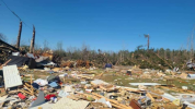
Unsure of the exact location of this row of homes, but they were destroyed with debris somewhat wind rowed and moderately granulated. Seems quite indicative of EF4 intensity though hard to gauge construction.

Not sure if this damage photo is from the same set of homes or not, but the debris pattern does seem quite typical of EF3/4 tornadoes, with some nasty tree damage in the background.
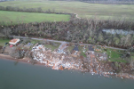
But the best candidate for EF4 damage probably comes from this home:


It was large with brick construction (see image below) so I assume it was at least somewhat well constructed. You can also see what looks like some sill plates on the foundation so I assume it wasn't a completely flat slab. The core of the tornado passed slightly to the right hence the entire structure is not destroyed. You can see the debris carried downwind and some fairly intense tree damage, too.

On top of structural damage, there was the asphalt scouring as posted above. Tree damage was quite consistently suggestive of intense/violent strength, with some areas of near complete blowdown and some minor debarking. All these things considered I'm fairly confident this was at least a low end EF4 intensity tornado, probably a little higher.


 )
)

")