Dang, that tornado was probably like manna from heaven for chasers after the atrocities of May and June. One event that's piqued my attention is the Brackettville, TX F4 of May 16, 1989. If you haven't heard of it, you're not alone. There's very little evidence of this tornado's existence aside from its presence in official databases and May 16 as a whole has been largely forgotten. There's some
footage of an HP supercell further north in the panhandle on Sam Barricklow's website and a youtube video with some snippets of TWC coverage of the day. I apologize in advance for the lack of photos, but that's the nature of this tornado.
Meteorologically speaking, May 16th was a fairly classic synoptically evident set up for the TX panhandle. A strong neutral/slightly pos tilt trough centered over the desert SW(AZ/NM border roughly) was pushing west, with an attendant deepening low and sharp dryline. Divergence in the jet was expected to support supercell structures in the panhandle and, with all that it mind, the NSSFC(precursor to SPC) issued a high risk for the OK/TX panhandles and western Oklahoma. For the most part, the high risk area underperformed, though an HP supercell(documented on Sam Barricklow's site) did produce a few tornadoes, including one F2, near the Bushland, TX area. It seems that unexpectedly weak llvl winds and the best instability being displaced from the lowest LCL's prevented the day from reaching its full potential in the Panhandle/W OK region.
As the dry line retreated toward the TX/Mexico border, drawing moister air westwards, low level winds increased substantially throughout Texas and surface winds began to back SE to ESE around the Brackettville area. As temperatures dropped throughout the evening, LCL heights responded accordingly, dipping below 1000m in the area. The responsible supercell initiated across the border near Del Rio, TX, an area that is apparently pretty ripe for violent supercell/tornado production. The Piedras Negras/Eagle Pass, TX EF4/EF3 in April 2007 and Ciudad Acuna EF4 in May 2015 were spawned in the same area west of the Sierra Madre mountain range. The complex topography in the region likely plays a role in promoting some of the insane supercells we see down there, similar to the Rockies and the western plains states.
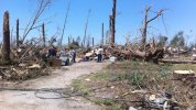
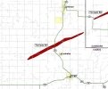
The responsible supercell crossed into Texas and began producing a tornado at approximately 11:08CT just to the south of Brackettville. It moved generally to the east for about 6 miles, sliding underneath Brackettville, at an unspecified lower-end intensity. Past the town the tornado began to deviate to the left, taking on a NNE motion and intensifying quite rapidly to its maximum intensity. Mesquite trees were snapped at ground level, debarked/denuded, and in some cases ripped out of the ground and thrown considerable distances. 40 yards of pavement was scoured from US 90 as the storm passed overhead and substantial ground scouring occurred over "a long stretch of the path", though the degree of scouring is unspecified and undocumented. The maximum damage intensity occurred over 6 miles of mostly uninhabited ranch land and only three homes, residing outside the most intense corridor of damage, were destroyed. The F4 rating was assigned almost exclusively due to the extensive tree damage and the ground/pavement scouring left behind. The tornado then began to turn back to the right(NNE to NE), producing F0-F1 damage for another 6 miles before dissipating.
A few hours later the same supercell would go on to produce the first, lesser known Jarrell, TX tornado, killing 1 and leaving widespread F3 damage in the area. Unlike most higher-end tornadoes in that area of SW to C Texas, the Brackettville F4 produced violent damage while moving at highway speed. It covered 20 miles over a span of 22 minutes, so roughly 50-60mph. Almost all of this information comes from a small blurb in the May 89 edition of Storm Data which, in contrast to the entry on the Bakersfield Valley storm a year later, features no damage photographs. Just a satellite image, a path map, and a rather vague description of the damage. I'm left wondering how intense it truly was and if it might've approached the ungodly intensity of the Bakersfield Valley F4. Unlikely, but certainly possible given the impressive damage descriptions and the dearth of reliable documentation.
All information sourced from:
https://www.ncdc.noaa.gov/IPS/sd/sd.html
https://www.spc.noaa.gov/exper/outbreaks/#
http://www.k5kj.net/19890516.HTM