• Welcome to TalkWeather!
    We see you lurking around TalkWeather! Take the extra step and join us today to view attachments, see less ads and maybe even join the discussion.
    CLICK TO JOIN TALKWEATHER
  • April 2024 Weather Video of the Month
    Post your nominations now!
Logo 468x120

locomusic01

Member
Messages
1,375
Reaction score
3,831
Location
Pennsylvania
Interesting about the expanding + strengthening stuff = Moshannon really blows right when it begins to enter the vast expanse of forest; perhaps that when the terrain became much more hilly and craggy?
Pretty much. It was like a third of a mile wide practically from the minute it touched down and did its most intense structural damage south of Penfield, but it blew up to 1.25+ miles right as it was entering Parker Dam. The terrain's pretty rough through that whole area, but it rises several hundred feet as you head into the park and there are multiple little gullies and valleys flowing into it.

It makes me wonder if stuff similar to Moshannon has occurred in the Adirondacks or upper state New York only it wasn't ever documented because so few, if any people saw it.
Also, almost all the state of Maine north of I-95 could have a monster wedge that wouldn't kill or injure anyone as it's practically all wilderness; the occasional town, village, camping site or timber mill would be the only man-made structures it would encounter. Wonder if it's already happened and of course, was never recorded.
IIRC, there was a tornado in New Hampshire near the Maine border in.. 2008? that was 50-something miles long and well over half a mile wide. The 7/10/89 tornado (probably tornado family) up near Albany was nearly 50 miles long and something like a mile wide. Some of the 5/31/98 tornadoes were rather large and long-tracked as well. Nothing like Moshannon obviously, but the point is that those kinds of events can and do happen up here.

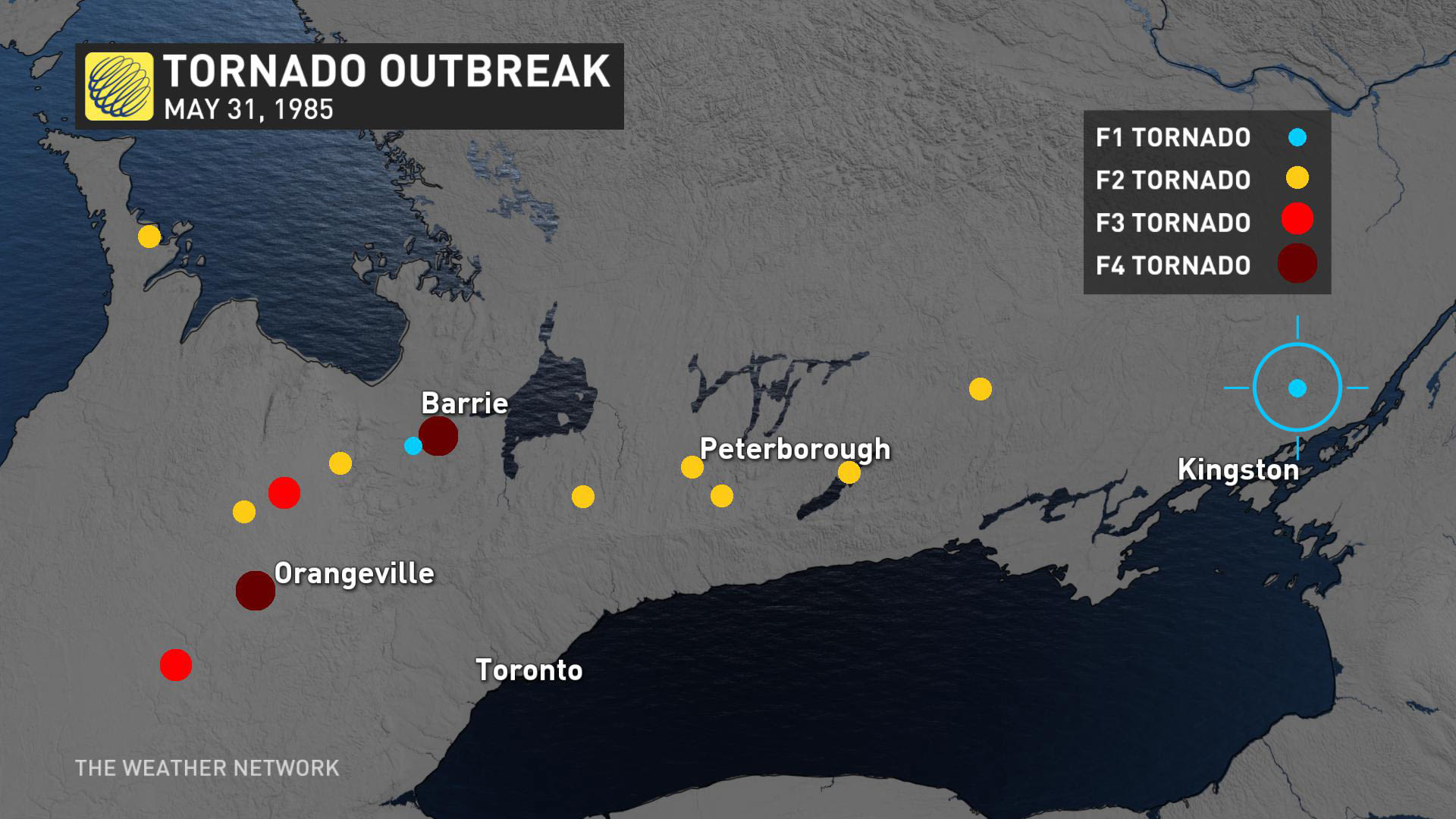
Incidentally, the 62 mile long F3 on 5/31/98 passed like 10 miles from where my family lived at the time and missed the stone mill where my dad worked by just a couple of miles. If only I'd been old enough to storm chase then lol
 

locomusic01

Member
Messages
1,375
Reaction score
3,831
Location
Pennsylvania
So here's something interesting. A while back, I talked to a woman who was just a kid on 5/31/85, and she said she remembered driving on some old back road with her father somewhere around Clarendon, PA, which is where they lived at the time. The weather started getting really bad and the wind picked up then she distinctly remembered hearing a roar and seeing trees "bending over like in a hurricane." She said she thought it was probably near one of the creeks in the area because her dad was big into trout fishing.

I wasn't aware of any tornado recorded in that area so I didn't think too much of it, but it's sort of been gnawing at the back of my brain for a while. I finally decided to check the satellite imagery (no idea why that hadn't occurred to me earlier) and lo and behold, look what pops up in far eastern Warren County after the outbreak:

lFdcuF5.jpg


That's the Allegheny Reservoir to the north, Warren in the northwest corner and Clarendon along the road to the west. The track is roughly five miles long and maxes out at ~600-700 yards wide. It lines up very closely with the path of the supercell that produced the Centerville and Thompson Run tornadoes, and it's also located very close to two different streams that are apparently known for good trout fishing.

I did some digging this afternoon and I found one mention of a "tornado swath" in this area buried in some land management study or some such, but that's about it. I don't really expect to find anything else out there since there literally isn't a single house around for 4-5 miles, but I'm pretty intrigued and I'm gonna keep looking.
 
Messages
2,904
Reaction score
4,809
Location
Madison, WI
So here's something interesting. A while back, I talked to a woman who was just a kid on 5/31/85, and she said she remembered driving on some old back road with her father somewhere around Clarendon, PA, which is where they lived at the time. The weather started getting really bad and the wind picked up then she distinctly remembered hearing a roar and seeing trees "bending over like in a hurricane." She said she thought it was probably near one of the creeks in the area because her dad was big into trout fishing.

I wasn't aware of any tornado recorded in that area so I didn't think too much of it, but it's sort of been gnawing at the back of my brain for a while. I finally decided to check the satellite imagery (no idea why that hadn't occurred to me earlier) and lo and behold, look what pops up in far eastern Warren County after the outbreak:

lFdcuF5.jpg


That's the Allegheny Reservoir to the north, Warren in the northwest corner and Clarendon along the road to the west. The track is roughly five miles long and maxes out at ~600-700 yards wide. It lines up very closely with the path of the supercell that produced the Centerville and Thompson Run tornadoes, and it's also located very close to two different streams that are apparently known for good trout fishing.

I did some digging this afternoon and I found one mention of a "tornado swath" in this area buried in some land management study or some such, but that's about it. I don't really expect to find anything else out there since there literally isn't a single house around for 4-5 miles, but I'm pretty intrigued and I'm gonna keep looking.

Great work!
 

MNTornadoGuy

Member
Messages
1,625
Reaction score
2,601
Location
Apple Valley, MN
So here's something interesting. A while back, I talked to a woman who was just a kid on 5/31/85, and she said she remembered driving on some old back road with her father somewhere around Clarendon, PA, which is where they lived at the time. The weather started getting really bad and the wind picked up then she distinctly remembered hearing a roar and seeing trees "bending over like in a hurricane." She said she thought it was probably near one of the creeks in the area because her dad was big into trout fishing.

I wasn't aware of any tornado recorded in that area so I didn't think too much of it, but it's sort of been gnawing at the back of my brain for a while. I finally decided to check the satellite imagery (no idea why that hadn't occurred to me earlier) and lo and behold, look what pops up in far eastern Warren County after the outbreak:

lFdcuF5.jpg


That's the Allegheny Reservoir to the north, Warren in the northwest corner and Clarendon along the road to the west. The track is roughly five miles long and maxes out at ~600-700 yards wide. It lines up very closely with the path of the supercell that produced the Centerville and Thompson Run tornadoes, and it's also located very close to two different streams that are apparently known for good trout fishing.

I did some digging this afternoon and I found one mention of a "tornado swath" in this area buried in some land management study or some such, but that's about it. I don't really expect to find anything else out there since there literally isn't a single house around for 4-5 miles, but I'm pretty intrigued and I'm gonna keep looking.
Is this tornado not listed in Storm Data or any other official storm survey?
 

locomusic01

Member
Messages
1,375
Reaction score
3,831
Location
Pennsylvania
Is this tornado not listed in Storm Data or any other official storm survey?
Nope. Also not on any survey maps that I've seen, nor is it mentioned anywhere else except in that land management study or whatever it was. The nearest officially recorded tornado is the Thompson Run F1, which dissipated just over 10 miles to the WSW. Probably pretty easy for it to go overlooked considering it's in the middle of nowhere and likely didn't hit anything other than trees. The only things there are a few forest service roads.
 

MNTornadoGuy

Member
Messages
1,625
Reaction score
2,601
Location
Apple Valley, MN
Nope. Also not on any survey maps that I've seen, nor is it mentioned anywhere else except in that land management study or whatever it was. The nearest officially recorded tornado is the Thompson Run F1, which dissipated just over 10 miles to the WSW. Probably pretty easy for it to go overlooked considering it's in the middle of nowhere and likely didn't hit anything other than trees. The only things there are a few forest service roads.
I guess that brings up the tornado count to 45.
 

locomusic01

Member
Messages
1,375
Reaction score
3,831
Location
Pennsylvania
I guess that brings up the tornado count to 45.
There may have been another tornado in far northwestern Trumbull County, OH as well, just between the Mesopotamia F3 and the Atlantic F4. An older lady who lived near Gustavus said that she heard a "rushing" sound and saw lots of branches and leaves and such flying through the air as the storm passed, and I found a news report that mentioned a strip of tree damage in that area roughly four miles long and a couple hundred yards wide. Not enough to say for certain, but it's right in sequence with the other tornadoes and it seems plausible that a brief, weak spin-up could've occurred.

Not sure I'd describe this one as "weak" though; assuming it is what it looks like, that's pretty significant tree damage.
 
Messages
2,255
Reaction score
2,850
Location
Missouri
There may have been another tornado in far northwestern Trumbull County, OH as well, just between the Mesopotamia F3 and the Atlantic F4. An older lady who lived near Gustavus said that she heard a "rushing" sound and saw lots of branches and leaves and such flying through the air as the storm passed, and I found a news report that mentioned a strip of tree damage in that area roughly four miles long and a couple hundred yards wide. Not enough to say for certain, but it's right in sequence with the other tornadoes and it seems plausible that a brief, weak spin-up could've occurred.

Not sure I'd describe this one as "weak" though; assuming it is what it looks like, that's pretty significant tree damage.
It really is amazing how many brief or weak tornadoes occur in outbreaks that were missed until relatively recently (2000s or so); so many outbreaks up throughout the 90s have a noticeable dearth of F0-F1s compared to F2+.
 
Messages
2,255
Reaction score
2,850
Location
Missouri
So here's something interesting. A while back, I talked to a woman who was just a kid on 5/31/85, and she said she remembered driving on some old back road with her father somewhere around Clarendon, PA, which is where they lived at the time. The weather started getting really bad and the wind picked up then she distinctly remembered hearing a roar and seeing trees "bending over like in a hurricane." She said she thought it was probably near one of the creeks in the area because her dad was big into trout fishing.

I wasn't aware of any tornado recorded in that area so I didn't think too much of it, but it's sort of been gnawing at the back of my brain for a while. I finally decided to check the satellite imagery (no idea why that hadn't occurred to me earlier) and lo and behold, look what pops up in far eastern Warren County after the outbreak:

lFdcuF5.jpg


That's the Allegheny Reservoir to the north, Warren in the northwest corner and Clarendon along the road to the west. The track is roughly five miles long and maxes out at ~600-700 yards wide. It lines up very closely with the path of the supercell that produced the Centerville and Thompson Run tornadoes, and it's also located very close to two different streams that are apparently known for good trout fishing.

I did some digging this afternoon and I found one mention of a "tornado swath" in this area buried in some land management study or some such, but that's about it. I don't really expect to find anything else out there since there literally isn't a single house around for 4-5 miles, but I'm pretty intrigued and I'm gonna keep looking.
In terms of other 'lost' or hard to find info from this outbreak, have you been able to find much damage pictures from Niles-Wheatland after it exited Wheatland and hit Hermitage and other areas in the Greenfield Township area? I've never been able to find much pictures of anything after Wheatland; you don't have to post any photos given how much of your article's already been spoiled lol.
 

locomusic01

Member
Messages
1,375
Reaction score
3,831
Location
Pennsylvania
In terms of other 'lost' or hard to find info from this outbreak, have you been able to find much damage pictures from Niles-Wheatland after it exited Wheatland and hit Hermitage and other areas in the Greenfield Township area? I've never been able to find much pictures of anything after Wheatland; you don't have to post any photos given how much of your article's already been spoiled lol.
Yeah I have a handful of photos from that area. I've been trying for months to get in contact with one woman in particular whose home was just obliterated near Greenfield; I finally talked to her a few days ago and she said she's got a small album of photos somewhere, so I'm really hoping she delivers. I have a kinda poor-quality aerial taken two weeks after the tornado and all that's left is a clean foundation, but obviously that was after a lot of cleanup had occurred.

From what I understand though, there wasn't a whole lot to clean up. You can see in the aerial that it took an absolutely direct hit from the very, very narrow core and she said her neighbor told her "the house just flew away and disintegrated." Thankfully she and her family weren't home when it hit, because it's hard to imagine how they'd have survived otherwise.

Edit: A woman also took a series of photos of the tornado from very near this area; I think I've probably posted a few of them before. In fact, it's entirely possible some of the debris visible in this shot is from that woman's house - I've sorta matched it up the best I could on Google Earth and it looks like the tornado's probably just a bit past her property here. This is also less than a mile from where the final fatality occurred.

p9m66ko.png
 

locomusic01

Member
Messages
1,375
Reaction score
3,831
Location
Pennsylvania
Oh, also, I have to double-check because for some reason I didn't label it but I'm pretty sure one of my favorite pictures I've gotten so far was taken in the Greenfield area. Granted, I'm easily amused, but the whole thing is just delightfully incongruous:

NaKsAWZ.jpg


Again I need to double-check, but I think this was taken in the same area as well:

39iMkWN.jpg


If I'm remembering correctly (which I may not be), the guy who gave them to me said there'd been someone in the car at the time. They must've survived because it doesn't fit any of the known fatalities, but.. yikes. Hard to see how anyone could come out of that alive.
 

MNTornadoGuy

Member
Messages
1,625
Reaction score
2,601
Location
Apple Valley, MN
Oh, also, I have to double-check because for some reason I didn't label it but I'm pretty sure one of my favorite pictures I've gotten so far was taken in the Greenfield area. Granted, I'm easily amused, but the whole thing is just delightfully incongruous:

NaKsAWZ.jpg


Again I need to double-check, but I think this was taken in the same area as well:

39iMkWN.jpg


If I'm remembering correctly (which I may not be), the guy who gave them to me said there'd been someone in the car at the time. They must've survived because it doesn't fit any of the known fatalities, but.. yikes. Hard to see how anyone could come out of that alive.
The Amish community in Atlantic PA was devastated by the F4 that went through there. The Amish are probably one of the most vulnerable communities in the United States to tornadoes as they usually don’t have ways to recieve warnings, a violent tornado hitting them is a worst case scenario.
 

locomusic01

Member
Messages
1,375
Reaction score
3,831
Location
Pennsylvania
The Amish community in Atlantic PA was devastated by the F4 that went through there. The Amish are probably one of the most vulnerable communities in the United States to tornadoes as they usually don’t have ways to recieve warnings, a violent tornado hitting them is a worst case scenario.
Yeah, several Amish communities were hit very hard, not just in PA/OH but in Canada as well. It's remarkable that only one Amish man was killed, and that was because he refused to take shelter even when he saw the tornado coming. They tend to be super weather-aware, but they're still at great risk.

And despite all the damage they suffered, they were the first folks to step up and volunteer to clear fallen trees, clean up debris, rebuild barns, etc. They even rebuilt houses for a few people I talked to. And for the most part they refused any kind of payment, or if they did accept it, they put it into community funds to help others. I lived near a large Amish community in Kentucky when I was younger and that totally tracks with how I remember them - super kind and generous and always looking out for others before themselves.
 
Messages
1,090
Reaction score
858
Location
texas
i love how pembroke was an EF5 candidate lmao. could you image if the first ef5 in 8 years was a short track in south eastern Georgia that swept away two random house's in a small subdivision.
 

locomusic01

Member
Messages
1,375
Reaction score
3,831
Location
Pennsylvania
pembroke was an EF5 candidate
When was it considered an EF5 candidate? Not intended to be snarky btw - I'm pretty much out of the loop on any recent events. From the little I saw, my impression was more low-mid EF4, which I think is about where it was rated.

On a related note, that kind of thing is probably more common than we realize. I've been surprised by how many of the tornadoes I've researched strengthened really quickly and reached/neared peak intensity quite early on. We tend to associate stronger tornadoes with longer tracks, but that's at least partly an artifact of sampling bias - longer-tracked storms have more chances to do damage. I'm sure we miss plenty of strong/violent tornadoes that spin up quickly but end up dissipating without hitting much.
 
Messages
1,090
Reaction score
858
Location
texas
large well built anchor bolted concrete foundation homes swept clean often means its an EF5 candidate before further analysis is done. aka looking at contextual damage and potential construction flaws.
 
Top