One interesting thing to note about the May 20, 2013, Moore, Oklahoma EF5 Tornado is what the radar picked up during tornadogenesis. The parent supercell was the only one to develop with a clear inflow notch, another cell to the south tried but was obscured. Despite this, the Moore Supercell had developed a hook echo and exhibited rather lower-end rotation for about 15 minutes prior to the tornado formation. The environment below certainly suggests the potential for tornadoes, but the lack of wind shear and kinematics doesn't exactly yell "VIOLENT TORNADO"
Observed Sounding from OKC at 18z (The tornado touched down at 19:56z)
View attachment 8993
However, an area of weak precipitation was seen moving towards the inflow notch of the tornadic supercell at around 1955z, and coincided with tornadogenesis.
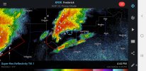
1952z. No tornado is on the ground, but a rotating wall cloud was seen on radar. Notice the convection approaching the inflow notch from the south.
View attachment 8994
1956z. The tornado has touched down. Notice how the supercell is beginning to absorb the convection.
View attachment 8995
2000z, the tornado is on the ground, and is producing high-end EF4 damage to homes along Stanton Lane, just north of Newcastle. As the supercell began to suck in the convection, it appears to have given it a "boost" of some sort. The velocity signature has intensified exceptionally.
View attachment 8996
The convection appeared to have had a major effect on the parent supercell, likely due to the margnial kinematics. As soon as the convection had been absorbed, the supercell and tornado began to deviate further east of the original track.
View attachment 8997