
Two storms near armory missippi are gaining supercellular features it seems
Navigation
Install the app
How to install the app on iOS
Follow along with the video below to see how to install our site as a web app on your home screen.
Note: This feature may not be available in some browsers.
More options
-
Welcome to TalkWeather! We see you lurking around TalkWeather! Take the extra step and join us today to view attachments, see less ads and maybe even join the discussion. CLICK TO JOIN TALKWEATHER
You are using an out of date browser. It may not display this or other websites correctly.
You should upgrade or use an alternative browser.
You should upgrade or use an alternative browser.
Severe WX Severe Wx Outbreak March 1st- 3rd, 2023 - Southern States, MS/OH/TN Valley
- Thread starter KevinH
- Start date
MoonBaby
Knew It Would Happen
Exactly. Looks like she may have her first non sick off day from school this year. She’s scared of being at school during a tornado so I would rather her school be mad at me than drop her off then immediately get a warning. I just don’t trust Alabama weather enough to assume things won’t ramp up the second I take her to school.Yes the sun has been battling the junk convection I mentioned earlier. Just don’t want to see the Sun on snow days nor storm days.
kcyalater
Member
the wind is absolutely nuts here in birmingham. i don’t think the timing of the line passing through will match up with any appreciable threat here, but areas north from cullman over to blue ridge, ga have to be a concern.
AREA FORECAST DISCUSSION
NATIONAL WEATHER SERVICE BIRMINGHAM AL
917 AM CST FRI MAR 3 2023
…NEW MESOSCALE UPDATE…
.MESOSCALE UPDATE FOR THE ONGOING SEVERE WEATHER THREAT…
ISSUED AT 917 AM CST FRI MAR 3 2023
MESOSCALE UPDATE.
THE ATMOSPHERIC CONDITIONS WILL BE QUITE UNUSUAL TODAY AS A
POWERFUL SHORTWAVE MOVES FROM THE LOWER MISSISSIPPI VALLEY TO THE
OHIO VALLEY. EXTREMELY STRONG WIND FIELDS WILL ACCOMPANY THIS
SYSTEM THROUGHOUT THE COLUMN AS A SURFACE LOW DEEPENS TO AROUND
978 MB NEAR PADUCAH AT NOON TODAY. THE WARMTH AND QUALITY OF
MOISTURE ALREADY IN PLACE ACROSS ALABAMA WOULD NORMALLY POINT TO A
TORNADO OUTBREAK. HOWEVER, THERE IS ONE SIGNIFICANTLY NEGATIVE
INGREDIENT TODAY WHICH MAKES THIS SETUP SO UNIQUE, WARM ADVECTION
AT 600 MB. IT IS NOT OFTEN THAT HIGH SEVERE WEATHER PARAMETERS ARE
WASTED IN ALABAMA, ESPECIALLY IN THE PRESENCE OF HEIGHT AND
PRESSURE FALLS. HOWEVER, IT APPEARS THAT NEARLY ALL PRE-FRONTAL
DEVELOPMENT WILL BE RESTRICTED BY THIS WARM LAYER. HEALTHY
UPDRAFTS SHOULD BE CONFINED ALONG THE COLD FRONT WHERE A QLCS IS
CURRENTLY BEING OBSERVED IN EASTERN MISSISSIPPI. THE QLCS IS
QUICKLY APPROACHING THE AL/MS STATE LINE AND WILL CROSS INTO OUR
NORTHWESTERN COUNTIES BY 10 AM. AS THIS MOVES ACROSS OUR FORECAST
AREA, THE MAIN IMPACTS SHOULD BE ACROSS OUR NORTHERN TWO ROWS OF
COUNTIES, CLOSER IN PROXIMITY TO THE UPPER-LEVEL SUPPORT AND
SLIGHTLY COOLER MID-LEVEL TEMPERATURES. WITH STRONG WIND FIELDS IN
PLACE, THESE STORMS MAY BE RATHER EFFICIENT AT PRODUCING WIND
GUSTS OF 60-70 MPH. A COUPLE OF LINE-EMBEDDED TORNADOES ARE ALSO
POSSIBLE. FARTHER SOUTH, THE MID-LEVEL WARM LAYER WILL BECOME
INCREASINGLY PROHIBITIVE TO UPDRAFT DEVELOPMENT, SO MUCH SO, THAT
DEWPOINTS OF 70F WILL NOT BE SUFFICIENT FOR DEEP CONVECTION.
87/GRANTHAM
Right…and maybe this is off topic but I have seen the severe weather plan at my daughter’s school…not naming names but it rhymes with PackAdory…during a Tornado Warning one afternoon it was chaos with a purported tornado making a bee line for the school. Half the grades were in the gym sitting on the bleachers and the others were in the lunchroom. Not good.Exactly. Looks like she may have her first non sick off day from school this year. She’s scared of being at school during a tornado so I would rather her school be mad at me than drop her off then immediately get a warning. I just don’t trust Alabama weather enough to assume things won’t ramp up the second I take her to school.
Love seeing a Grantham forecast - An excellent Talkweather alum.
From FFC. Notes lapse rates increasing in the mid-levels.
.UPDATE...
Issued at 943 AM EST Fri Mar 3 2023
The only major change to the forecast was to slow down the line of
TSRA. Overall, the trends for the last few runs of the models
(synoptic and hi-res) is to slow down the line as is approaches
the CWA. Timing now looks to be mostly in the afternoon vs late
morning/early afternoon.
500mb analysis shows a negatively tilted trough across AR, about
to approach the middle Mississippi River. The associated mid level
low is across south central MO. The trough and low pressure system
will rapidly push NE today into the Ohio Valley. At the surface, a
cold front is moving through central Mississippi. Currently, there
is only a very skinny line of shra/tsra along or just ahead of the
front. The line should push into AL later this morning increasing
in intensity. There is still potential for strong/severe storms
this afternoon, especially across northern GA...closest to the
strong dynamics aloft. The morning sounding continues to show warm
air aloft centered around 700mb. If this cap can erode, the
potential for severe weather will increase. Currently, skies are
mostly cloudy across north and central GA. SE GA broke out a
little earlier, but the clouds will fill in within the next few
hours. However, there are some breaks in the clouds noted across
central AL moving east. If the breaks become more prevalent,
surface instability will begin to increase. In addition, mid
level lapse rates are running quite a bit steeper than they were
this morning...with values around 7-7.5 C/km. Winds aloft are very
strong, with the 850mb jet a bit stronger than previous
forecasts. Any convection will be able to mix down these strong
winds, so even the shra will be gusty. The primary hazard for any
severe thunderstorms will be damaging wind gusts...but the
potential for a few tornadoes also exists, especially across the
northern CWA.
The gradient will continue to tighten the next couple of hours.
Sustained winds/gusts have been slow to increase this morning
under the clouds/light precip. Do expect winds to pick up by late
morning/early afternoon. No changes to the advisory are planned at
this time.
yep I member him from when this board was barely a board.Love seeing a Grantham forecast - An excellent Talkweather alum.
Slowing down the line and higher mid level lapse rates are bad for central Alabama.From FFC. Notes lapse rates increasing in the mid-levels.
MoonBaby
Knew It Would Happen
Same. Not naming names either but last year a tornado went just south of us. While I knew it was south, nobody else in the drive line did and all the parents are just lined up in cars while the kids were in THE GYM. That was her elementary school though, she’s in middle now. This was also during pick up time. Had a tornado been actually on that path all those cars and parents would have been flying, and god forbid it hit the gym. I just don’t take chances with all that.Right…and maybe this is off topic but I have seen the severe weather plan at my daughter’s school…not naming names but it rhymes with PackAdory…during a Tornado Warning one afternoon it was chaos with a purported tornado making a bee line for the school. Half the grades were in the gym sitting on the bleachers and the others were in the lunchroom. Not good.
.png")
brianc33710
Member
So will we (Bham) actually see any severe weather threat today? I stayed home from work but want to go at 12 if threats aren't there. The fact we aren't in a watch box makes me feel things will stay N & W of here.Slowing down the line and higher mid level lapse rates are bad for central Alabama.
I wouldn't bet on much maybe some damaging winds at this point. No healthy supercells structures yet it seems so I think it bodes wellSo will we (Bham) actually see any severe weather threat today? I stayed home from work but want to go at 12 if threats aren't there.
Equus
Member
Morning soundings for reference
BMX; warm nose aloft evident but look at that low level hodo, just a vicious wind profile

JAN; still with the lapse rate issues but vicious wind profile

BMX; warm nose aloft evident but look at that low level hodo, just a vicious wind profile
JAN; still with the lapse rate issues but vicious wind profile
SPC says more WWs will be needed today for multiple areas.
383
ACUS11 KWNS 031616
SWOMCD
SPC MCD 031615
KYZ000-TNZ000-GAZ000-INZ000-ALZ000-ILZ000-031915-
Mesoscale Discussion 0244
NWS Storm Prediction Center Norman OK
1015 AM CST Fri Mar 03 2023
Areas affected...much of Kentucky...far southern Indiana...Middle
Tennessee...northern Alabama
Concerning...Tornado Watch 60...
Valid 031615Z - 031915Z
The severe weather threat for Tornado Watch 60 continues.
SUMMARY...The threat for tornadoes will increase through the
afternoon, from near the Ohio River southward into northern Alabama
and eventually Georgia. Additional watches are likely later today
east of ongoing tornado watch #60.
DISCUSSION...A surface low near the IL/KY border will continue to
deepen today as it travels up the OH River Valley and near a warm
front. Areas of thunderstorms are ongoing near the low, with an
arcing line of cells extending south into northern AL. Breaks in the
clouds as well as strong southerly advection will continue to
destabilize the warm sector, with sufficient instability forecast to
support supercells with tornadoes by afternoon.
Limited instability near the warm front will be mitigated by very
strong lift combined with cooling aloft, and these height falls will
extend southward into Middle TN. Midlevel lapse rates will be
steeper beneath the midlevel wave, with the surface low track and
warm front zone being a favored area for tornadoes, some strong.
Initial convection near the low has periodically shown signs of
rotation.
Ongoing storms from middle TN into northwest AL will continue to
strengthen as well, aided by higher boundary-layer theta-e despite
being south of the midlevel jet core. Very strong shear is in place
across the entire region, favoring fast-moving supercells and
tornado threat.
..Jewell/Grams.. 03/03/2023
...Please see www.spc.noaa.gov for graphic product...
ATTN...WFO...MRX...JKL...FFC...LMK...OHX...BMX...HUN...PAH...
MEG...
LAT...LON 36428468 35868491 34948539 34468576 34208624 34088668
33908755 33938806 34368795 35048787 35698784 36338797
36708834 37168888 37648799 38208682 38438583 38408503
38208447 37808423 37508425 37098435 36428468
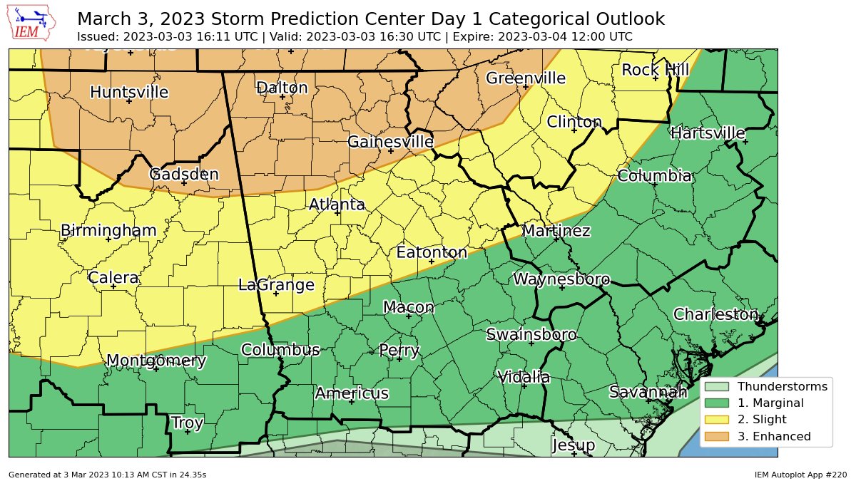
ENH brought south for winds; 5% TOR threat also brought southward.ENH dropped southward. Awaiting hazard-specific deets.
RollTide18
Member
brianc33710
Member
I have heard & read we actually have "too much" shear today for supercell formation. If the WW still stay N of BHM when extended I'll go in.SPC says more WWs will be needed today for multiple areas.
Chris3024
Member
Uptick in lightning near Hackleburg