MattW
Member
- Messages
- 388
- Reaction score
- 382
- Location
- Decatur, GA
- HAM Callsign
- KG4GUF
- Special Affiliations
- SKYWARN® Volunteer
At this range, with the GFS speeding up, and the NAM slowing down, which one do we trust more?
Follow along with the video below to see how to install our site as a web app on your home screen.
Note: This feature may not be available in some browsers.
Very concerning no doubt about it. I'm afraid we are gunna overlook this and it could go on to produce a ef3/ef4 or something and really damage some communitiesReally creepy to be honest.
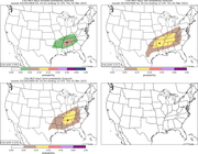
You were the 1st to jump on this man, I wasn't even looking at this until you first posted something earlier today good eye. Switching my focus. Gunna see what the WRF saysJust shy of showing 10% tornado probs on the map for tomorrow. Max probs on wind and hail are also a good bit higher than 15% as they show at over 20%.
I hope this thing will stay from me but y'all keep creeping west every new forecast.12Z 3KM NAM at FH60 has first CAM sniff at 00Z Friday...shows semi-discrete cells just recently fired along the I-35 corridor in TX.


.png")

Perfect critical angle oof.

Please keep sharing your graphics am using them to send my friends and relatives back in Mississippi & Alabama
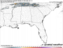
I'm beginning to be concerned about the environment over North and Central Georgia on Friday, and even into Eastern Alabama. Still a lot of pieces that are moving and confidence in timing needs to increase. Nevertheless, most guidance is illuminating the potential for a robust severe event.Wednesday is a classic day before the day. Looks a lot like 4/11 last year, going to get some big hailers and brief tors, and possibly a sigtor or two in the vicinity of the warm front.
Thursday looks like it has a very high ceiling. NAM has some massive VB due to very weak 800s right around the level of the EML, and global models are picking up on it too. Interested to see CAM outputs tonight and if they replicate this.
Friday is being seriously underforecasted imo. Looks like a potentially big day whether QLCS or cellular driven. I'm particularly worried because pattern recognition tells me some confluence bands are likely in the warm sector, which would make that day particularly dangerous considering discrete development would be likely should that scenario unfold.
Edit: random comment but this thread name is WAY TOO LONG lol
Your all good I love the articles you send I ain't gunna learn if I don't know important things like some.of theseI know I'm posting research papers too much, but (and this isn't directed at you) critical angle can be much looser than having a pure 90 degree angle. In fact, 60 degrees is a better discriminator. Too small or too large of an angle is more unfavorable. Also, the streamwise vorticity component in the lowest 0.5 km is very important in tornado production, as the study outlines. On that particular sounding, there is a large amount of vorticity available and its almost purely streamwise in the lowest km.
Using Near-Ground Storm Relative Helicity in Supercell Tornado Forecasting
Abstract This study examines the possibility that supercell tornado forecasts could be improved by utilizing the storm-relative helicity (SRH) in the lowest few hundred meters of the atmosphere (instead of much deeper layers). This hypothesis emerges from a growing body of literature linking the...journals.ametsoc.org
I'm torn between North Georgia and South Georgia as the starting point. There are definitely some concerning soundings coming from the I-20 area midday, but there's also a lot of support for the start to be south of Columbus.I'm beginning to be concerned about the environment over North and Central Georgia on Friday, and even into Eastern Alabama. Still a lot of pieces that are moving and confidence in timing needs to increase. Nevertheless, most guidance is illuminating the potential for a robust severe event.