xJownage
Member
Wednesday is a classic day before the day. Looks a lot like 4/11 last year, going to get some big hailers and brief tors, and possibly a sigtor or two in the vicinity of the warm front.
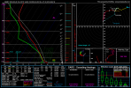
Thursday looks like it has a very high ceiling. NAM has some massive VB due to very weak 800s right around the level of the EML, and global models are picking up on it too. Interested to see CAM outputs tonight and if they replicate this.
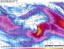
Friday is being seriously underforecasted imo. Looks like a potentially big day whether QLCS or cellular driven. I'm particularly worried because pattern recognition tells me some confluence bands are likely in the warm sector, which would make that day particularly dangerous considering discrete development would be likely should that scenario unfold.
Edit: random comment but this thread name is WAY TOO LONG lol
Thursday looks like it has a very high ceiling. NAM has some massive VB due to very weak 800s right around the level of the EML, and global models are picking up on it too. Interested to see CAM outputs tonight and if they replicate this.
Friday is being seriously underforecasted imo. Looks like a potentially big day whether QLCS or cellular driven. I'm particularly worried because pattern recognition tells me some confluence bands are likely in the warm sector, which would make that day particularly dangerous considering discrete development would be likely should that scenario unfold.
Edit: random comment but this thread name is WAY TOO LONG lol
Last edited:


")