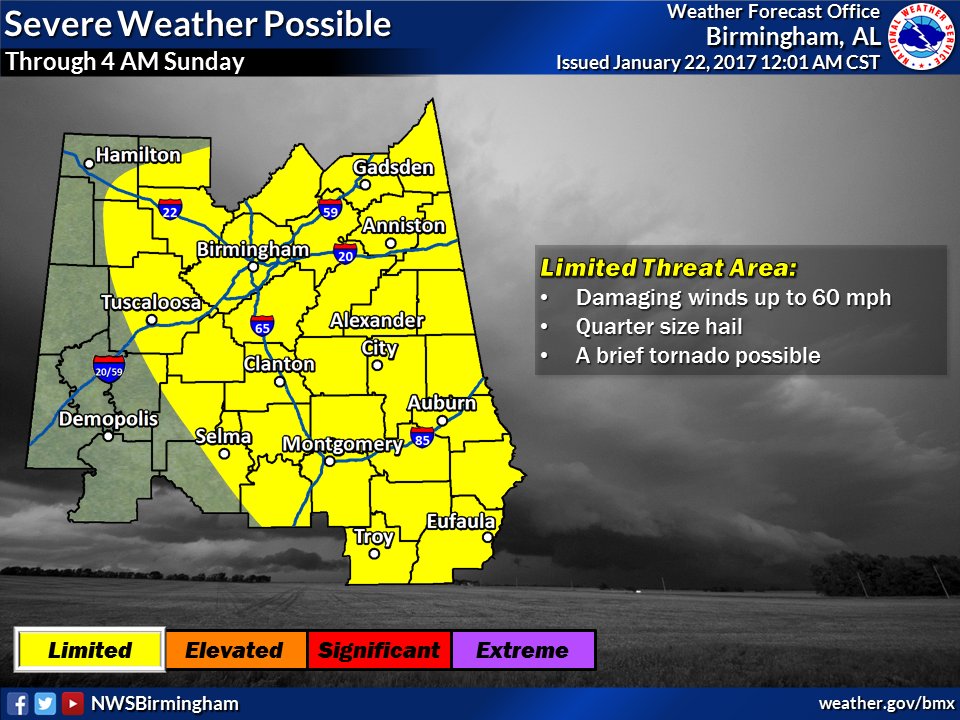
• Welcome to TalkWeather!
    We see you lurking around TalkWeather! Take the extra step and join us today to view attachments, see less ads and maybe even join the discussion.
    CLICK TO JOIN TALKWEATHER

Severe WX Severe Weather Threats 1/21-1/22 2017 (Saturday - Sunday)

Hopefully you are right about tonight not being bad. Alabamawx.com says a special weather balloon launch (bham) a few hours ago (or less?) shows the presence of a low level inversion inhibiting greater severe weather formation. They also say the inversion should disappear in the next few hours.

Can anyone tell us more about the role of low level inversions relative to severe weather?

An inversion is a cool layer of air at the surface or a warm layer off the ground. A good analogy is like a ladder. A normal ladder would represent a column of air where the temperture decreases with height, such as you climb from rung to rung.

Now let's say you had a ladder that was missing the first few rungs. You would have to get higher to climb it or you may not be able to climb it at all.

Right now we have elevated convection or storms rooted above the surface. They are growing on top of the cool layer above the ground because the cool layer is inhibiting air rising. You need storms to grow surface based to produce significant severe weather.
 
Last edited:
Hopefully you are right about tonight not being bad. Alabamawx.com says a special weather balloon launch (bham) a few hours ago (or less?) shows the presence of a low level inversion currently inhibiting greater severe weather formation. They also say the inversion should disappear in the next few hours.

Can anyone tell us more about the role of low level inversions relative to severe weather?
An inversion is when temperatures increase with height (opposite of normal atmosphere). this warmer air caps the atmosphere and doesn't allow air partials to rise-necessary for storms. 2 things have to happen-either the warmer air becomes warmer than the inversion temps or the inversion is replaced by cooler air. So far this evening the air partials have been rising above the inversion...when they start rising below it, closer to the ground, the storm can become stronger.
 
New day 1 convective outlook. **Valid starting at 6am CST**

AL_swody1.png
 
NWS Birmingham has lowered the threat.
C2wQlPCVEAAXfMg.jpg:large
 
Surprisingly moderate rain falling now as the curling band of the cluster has arrived in Jasper. I know it's stronger just to our south but with the occasional thunder and gentle rain, I'll probably doze off not too long from now. Not super impressed by the overall threat unless the LLJ really starts making its move, but I do wonder if things could get rough for SE AL into S GA like yesterday.
 
WTVY 4 in Dothan has been wall to wall for a good while now covering occasional severe thunderstorm and flash flood warnings. Hopefully that is all they will have to talk about for our area!
 
Surprisingly moderate rain falling now as the curling band of the cluster has arrived in Jasper. I know it's stronger just to our south but with the occasional thunder and gentle rain, I'll probably doze off not too long from now. Not super impressed by the overall threat unless the LLJ really starts making its move, but I do wonder if things could get rough for SE AL into S GA like yesterday.
I'm ready to get this line through where I am in Morris. I'd like to head to bed, too!
 
An MCS is a cool system. The MCS over west AL is acting as its own system now, you can see the warm and cool fronts related to the mesolow.
 
In a span of less than 6 hrs we have gone from a PDS to a 'limited' prediction of severe weather. From a forecasting perspective something major did not occur that was supposed to or did occur that was not supposed to. Was it the capping? The formation of an MCS? A combination of factors? I am honestly curious about the dynamics behind what some people are already calling a major forecast Forecasted Convective Amplification Deficiency for tonight (Facebook, etc).

I realize that it is just 1 AM (CST) & plenty can still happen. But BMX has stated that the severe weather threat is decreasing overnight.

What factors came into play to change things?
 
Passing close to the 'eye' of the MCS. Pretty cool. Good thing it wasn't especially strong.

Given the strong wording from earlier and the PDS, I'm not expecting the secondary moderate risk or the watch to verify at all at this point... storm mode remains a mess. Only really interesting places to watch remain south of Columbus, GA.
 
Definitely a big Forecasted Convective Amplification Deficiency, great for those who were/are in the watch, a bad look from a forecasting standpoint. I was a bit skeptical from the moment the PDS came out. When it comes to weather sometimes you win sometimes you lose. I want to be careful about being too critical these people have a tough job it's never easy to pull the trigger on a watch like that.
 
Slightly off topic, but I am ready for the day when weather radios become polygon based. Gotta love when it goes off for a warning in the other end of the county and wakes the whole house up. It's just doing its job, but I wish it could do it in the way that the apps do.
 
Back
Top