• Welcome to TalkWeather!
    We see you lurking around TalkWeather! Take the extra step and join us today to view attachments, see less ads and maybe even join the discussion.
    CLICK TO JOIN TALKWEATHER
Logo 468x120

Severe WX Severe Weather Threats 1/21-1/22 2017 (Saturday - Sunday)

WesL

"Bill, I'm talkin' imminent rueage"
Staff member
Administrator
Moderator
Sustaining Member
Messages
3,344
Reaction score
2,614
Location
Fayetteville, AR
Special Affiliations
  1. SKYWARN® Volunteer
FFC continues Tornado Warning [tornado: OBSERVED, tornado damage threat: CONSIDERABLE, hail: 1.00 IN] for Dodge, Laurens, Telfair, Wheeler, Wilcox [GA] till 5:00 PM EST
 

TWBot

TalkWeather Bot
Don't Feed The Bots
Messages
542
Reaction score
2
Location
On a server
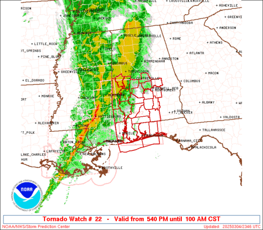
WW 22 TORNADO GA SC CW 222125Z - 230300Z


URGENT - IMMEDIATE BROADCAST REQUESTED
Tornado Watch Number 22
NWS Storm Prediction Center Norman OK
425 PM EST Sun Jan 22 2017

The NWS Storm Prediction Center has issued a

* Tornado Watch for portions of
Southeast Georgia
Central and Southern South Carolina
Coastal Waters

* Effective this Sunday afternoon and evening from 425 PM until
1000 PM EST.

...THIS IS A PARTICULARLY DANGEROUS SITUATION...

* Primary threats include...
Several tornadoes and a few intense tornadoes likely
Scattered damaging winds likely with isolated significant gusts
to 75 mph possible
Scattered large hail events to 1.5 inches in diameter possible

SUMMARY...Intense supercell thunderstorms over central Georgia will
track eastward across the watch area late this afternoon and
evening. strong tornadoes are damaging winds are possible with the
strongest cells.

The tornado watch area is approximately along and 80 statute miles
north and south of a line from 55 miles west of Savannah GA to 35
miles east southeast of Charleston SC. For a complete depiction of
the watch see the associated watch outline update (WOUS64 KWNS
WOU2).

PRECAUTIONARY/PREPAREDNESS ACTIONS...

REMEMBER...A Tornado Watch means conditions are favorable for
tornadoes and severe thunderstorms in and close to the watch
area. Persons in these areas should be on the lookout for
threatening weather conditions and listen for later statements
and possible warnings.

&&

OTHER WATCH INFORMATION...CONTINUE...WW 21...

AVIATION...Tornadoes and a few severe thunderstorms with hail
surface and aloft to 1.5 inches. Extreme turbulence and surface wind
gusts to 65 knots. A few cumulonimbi with maximum tops to 450. Mean
storm motion vector 24040.

...Hart


Read more

Continue reading...
 

Equus

Member
Messages
3,290
Reaction score
3,368
Location
Jasper, AL
Special Affiliations
  1. SKYWARN® Volunteer
Highly discrete cells appear to be developing ahead of the main line offshore Tampa. That's highly concerning.
 

Equus

Member
Messages
3,290
Reaction score
3,368
Location
Jasper, AL
Special Affiliations
  1. SKYWARN® Volunteer
PDS TOR watch now out for much of northern peninsular FL. It's an 80/80. There are now three PDS tornado watches in effect.
 
Messages
78
Reaction score
39
Location
Center Point Alabama
Highly discrete cells appear to be developing ahead of the main line offshore Tampa. That's highly concerning.
* SPECIAL MARINE WARNING FOR...
COASTAL WATERS FROM TARPON SPRINGS TO SUWANNEE RIVER FL OUT 20
NM...
TAMPA BAY WATERS...
WATERS FROM TARPON SPRINGS TO SUWANNEE RIVER FL OUT 20 TO 60 NM...

* UNTIL 600 PM EST

* AT 432 PM EST...SEVERE THUNDERSTORMS WERE LOCATED ALONG A LINE
EXTENDING FROM 25 NM SOUTHEAST OF BUCKEYE REEF TO 75 NM WEST OF
ANCLOTE KEY...MOVING EAST AT 55 KNOTS. THIS LINE OF STORMS IS
CAPABLE OF PRODUCING WINDS IN EXCESS OF 50 KNOTS ALONG WITH
RAPIDLY DEVELOPING WATERSPOUTS.
 

TWBot

TalkWeather Bot
Don't Feed The Bots
Messages
542
Reaction score
2
Location
On a server
WW 23 TORNADO FL CW 222135Z - 230300Z


URGENT - IMMEDIATE BROADCAST REQUESTED
Tornado Watch Number 23
NWS Storm Prediction Center Norman OK
435 PM EST Sun Jan 22 2017

The NWS Storm Prediction Center has issued a

* Tornado Watch for portions of
Central Florida
Coastal Waters

* Effective this Sunday afternoon and evening from 435 PM until
1000 PM EST.

...THIS IS A PARTICULARLY DANGEROUS SITUATION...

* Primary threats include...
Several tornadoes and a few intense tornadoes likely
Widespread damaging wind gusts to 70 mph likely
Scattered large hail events to 1.5 inches in diameter possible

SUMMARY...A line of supercell thunderstorms over the Gulf Of Mexico
will track eastward across central FL late this afternoon and
evening, posing a risk of tornadoes and damaging wind gusts. Strong
tornadoes are possible.

The tornado watch area is approximately along and 55 statute miles
east and west of a line from 35 miles northeast of Ocala FL to 35
miles southeast of Sarasota FL. For a complete depiction of the
watch see the associated watch outline update (WOUS64 KWNS WOU3).

PRECAUTIONARY/PREPAREDNESS ACTIONS...

REMEMBER...A Tornado Watch means conditions are favorable for
tornadoes and severe thunderstorms in and close to the watch
area. Persons in these areas should be on the lookout for
threatening weather conditions and listen for later statements
and possible warnings.

&&

OTHER WATCH INFORMATION...CONTINUE...WW 21...WW 22...

AVIATION...Tornadoes and a few severe thunderstorms with hail
surface and aloft to 1.5 inches. Extreme turbulence and surface wind
gusts to 60 knots. A few cumulonimbi with maximum tops to 500. Mean
storm motion vector 25040.

...Hart


Read more

Continue reading...
 

xJownage

Member
Messages
570
Reaction score
604
Location
Jacksonville, Florida
Really unimpressed with any of the action going on, which is realistically a very good thing. I am a bit worried about the discrete cells forming in the gulf ahead of the main line, but that's about it.
 

Equus

Member
Messages
3,290
Reaction score
3,368
Location
Jasper, AL
Special Affiliations
  1. SKYWARN® Volunteer
C2zoUMUWEAErDom.jpg
 

Equus

Member
Messages
3,290
Reaction score
3,368
Location
Jasper, AL
Special Affiliations
  1. SKYWARN® Volunteer
They are clearly rotating a bit, even if lightning output and overall growth on reflectivity isn't that impressive yet.
 

Kory

Member
Messages
4,928
Reaction score
2,119
Location
Tuscaloosa, Alabama
Winds are veered across the Florida Peninsula last I checked. That was the issue this morning across the Panhandle but quickly backed in Southern GA where the violent Albany storm moved through.

Death toll is now up to 16. Vast majority in mobile homes. No ifs, ands, or buts....you HAVE to get out the minute a watch is issued. Go spend a day at a public library or something. Maybe these counties can start opening shelters in sturdy public buildings (if they don't already).
 

Equus

Member
Messages
3,290
Reaction score
3,368
Location
Jasper, AL
Special Affiliations
  1. SKYWARN® Volunteer
TOR just issued for storm moving in near Holiday, FL

C2zzxyiXAAApGmx.jpg
 
Back
Top