
Navigation
Install the app
How to install the app on iOS
Follow along with the video below to see how to install our site as a web app on your home screen.
Note: This feature may not be available in some browsers.
More options
-
Welcome to TalkWeather! We see you lurking around TalkWeather! Take the extra step and join us today to view attachments, see less ads and maybe even join the discussion. CLICK TO JOIN TALKWEATHER
You are using an out of date browser. It may not display this or other websites correctly.
You should upgrade or use an alternative browser.
You should upgrade or use an alternative browser.
Severe Weather Threat - October 25/26th, 2025
- Thread starter WeathermanLeprechaun
- Start date
- Thread starter
- #142
WeathermanLeprechaun
Member
Jeez
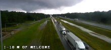
WATCHING a clear circulation west of Welcome, tornado is trying to develop!
Attachments
- Thread starter
- #143
WeathermanLeprechaun
Member
- Thread starter
- #144
WeathermanLeprechaun
Member
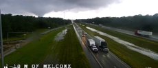
And it fell apart thankfully!
Kds86z
Member
Funnel cloud reported.
Kds86z
Member
Kds86z
Member
My Dad is down near Orange Beach right now. He called and asked me to check on the tornado warning. I did and told him that if he's within the warning polygon he should take cover, but if not he doesn't need to worry for now (knock on wood!).
Kds86z
Member
Dang! Glad he’s ok. Definitely was one on ground as you see below.My Dad is down near Orange Beach right now. He called and asked me to check on the tornado warning. I did and told him that if he's within the warning polygon he should take cover, but if not he doesn't need to worry for now (knock on wood!).
Last edited:
akt1985
Member
Besides the severe weather risk, there is a high risk of rough surf and rip currents at the coast today.
Kds86z
Member
akt1985
Member
I thought the rain would be heavier in north Alabama this afternoon. I’m going to assume the scenario is stronger than forecast storms at the coast robbing north Alabama of heavier rain. Regardless, it’s a relaxing rain.
joshoctober16
Member

sea pilger like event.
Kds86z
Member
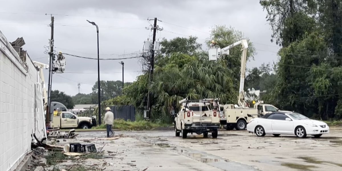
Damage reported in multiple cities after two tornadoes confirmed in South Mississippi, officials say
Officials are reporting damage following severe weather and tornadoes in multiple cities across South Mississippi.
 www.wlox.com
Dang! Glad he’s ok. Definitely was one on ground as you see below.
He said he saw it. He didn’t get a pic himself, but he did share with me a screenshot of someone else’s image:

Kds86z
Member
Oh dangHe said he saw it. He didn’t get a pic himself, but he did share with me a screenshot of someone else’s image:
View attachment 47930
- Thread starter
- #157
WeathermanLeprechaun
Member
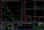
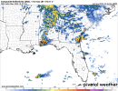
Don't think I'll extend thread again just for this alone but HRRR wants a conditional overnight tornado threat with this supercell in SW AL albeit briefly on shore from 03-04z
Overnight LLJ picks up and effective shear peaks around 60 kts but slight surface inversion may keep it at bay plus poor mid level lapse rates.
I've came to find out mid level lapse rates matter more with your general systems. MCVs and tropical outer bands have a gateway past the issue due to the fact cells are latched onto the low pressure of sorts and practically feeding off that low as a result. Interesting overnight setup, and since I'm tracking Melissa, i will monitor around this time JUST in case.
Attachments
Kds86z
Member
Don't think I'll extend thread again just for this alone but HRRR wants a conditional overnight tornado threat with this supercell in SW AL albeit briefly on shore from 03-04z
Overnight LLJ picks up and effective shear peaks around 60 kts but slight surface inversion may keep it at bay plus poor mid level lapse rates.
I've came to find out mid level lapse rates matter more with your general systems. MCVs and tropical outer bands have a gateway past the issue due to the fact cells are latched onto the low pressure of sorts and practically feeding off that low as a result. Interesting overnight setup, and since I'm tracking Melissa, i will monitor around this time JUST in case.
NEAR FLORIDA'S SPACE COAST, COASTAL CONVERGENCE ENHANCED BY MOIST,
POTENTIALLY UNSTABLE ONSHORE EASTERLY LOW-LEVEL FLOW HAS CONTRIBUTED
TO SUFFICIENT LIFT TO OVERCOME MID-LEVEL INHIBITION. IN THE
PRESENCE OF MODERATE SHEAR BENEATH MODEST WESTERLY MID/UPPER
WESTERLIES, IT APPEARS THAT THE ENVIRONMENT MAY REMAIN MARGINALLY
CONDUCIVE TO OCCASIONAL EVOLUTION OF SUPERCELL STRUCTURES INTO AT
LEAST MID TO LATE EVENING.
..KERR.. 10/27/2025
Kds86z
Member
akt1985
Member
There is a Tornado Warned storm near Melbourne, Florida that is moving an odd direction, West.