CheeselandSkies
Member
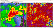
It's so close to the GWX radar and the radar is slicing through the back of the storm now, it's hard to get a good picture of what's really going on.
Follow along with the video below to see how to install our site as a web app on your home screen.
Note: This feature may not be available in some browsers.
Ya believe it or not it's technically not, just that one county, lol.I thought it was, he spent a lot of time on that storm that was moving in from MS on 4/27. The one that eventually hit Haleyville. And he was bouncing back to it while the Tuscaloosa tornado was ongoing.

Jason Simpson is on though. TWC says storm cycling.Spann is live on youtube, Lamar County isn't in his DMA.
Sent from my SM-S901U using Tapatalk
Jason Simpson is on though. TWC says storm cycling.
Severe Weather Statement
National Weather Service Jackson MS
649 PM CST Tue Nov 29 2022
LAC041-065-107-300115-
/O.CON.KJAN.TO.W.0094.000000T0000Z-221130T0115Z/
Tensas LA-Madison LA-Franklin LA-
649 PM CST Tue Nov 29 2022
...A TORNADO WARNING REMAINS IN EFFECT UNTIL 715 PM CST FOR
NORTHWESTERN TENSAS...SOUTHWESTERN MADISON AND NORTHEASTERN FRANKLIN
PARISHES...
At 649 PM CST, a confirmed tornado was located near Bakers, or 15
miles northeast of Winnsboro, moving northeast at 50 mph.
HAZARD...Damaging tornado and ping pong ball size hail.
SOURCE...Radar confirmed tornado.
IMPACT...Flying debris will be dangerous to those caught without
shelter. Mobile homes will be damaged or destroyed. Damage
to roofs, windows, and vehicles will occur. Tree damage is
likely.
This tornadic thunderstorm will remain over mainly rural areas of
northwestern Tensas, southwestern Madison and northeastern Franklin
Parishes.
tornado still chugging along in the radar hole in NE LA
Yeah like we said if we got a right-mover in this environment it was gonna be bad news (even if the big hodos didn't verify).That Steens/Columbus/Lamar Co., AL storm is a hard right mover. Couplet tracked almost due east.
URGENT - IMMEDIATE BROADCAST REQUESTED
TORNADO WATCH NUMBER 575
NWS STORM PREDICTION CENTER NORMAN OK
650 PM CST TUE NOV 29 2022
THE NWS STORM PREDICTION CENTER HAS ISSUED A
* TORNADO WATCH FOR PORTIONS OF
EXTREME SOUTHEAST ARKANSAS
NORTHEAST LOUISIANA
CENTRAL MISSISSIPPI
* EFFECTIVE THIS TUESDAY NIGHT AND WEDNESDAY MORNING FROM 650 PM
UNTIL 200 AM CST.
..THIS IS A PARTICULARLY DANGEROUS SITUATION
* PRIMARY THREATS INCLUDE...
SEVERAL TORNADOES AND A FEW INTENSE TORNADOES LIKELY
SCATTERED DAMAGING WIND GUSTS TO 70 MPH POSSIBLE
SCATTERED LARGE HAIL EVENTS TO 1.5 INCHES IN DIAMETER POSSIBLE
SUMMARY...SCATTERED SUPERCELLS WILL PERSIST THROUGH EARLY TONIGHT,
WITH A CONTINUED THREAT FOR A FEW STRONG TORNADOES, DAMAGING GUSTS,
AND LARGE HAIL. SOME UPSCALE GROWTH INTO LINE SEGMENTS IS EXPECTED
LATER TONIGHT AS A COLD FRONT APPROACHES FROM THE NORTHWEST.

That’s my town. It’s good - not collapsed.Malone's grocery in Steens, MS reported collapsed with entrapment and injuries.
Sent from my SM-S901U using Tapatalk
they are?Things MAY be calming down somewhat. Hope so.
they are?