wx_guy
Member
- Messages
- 1,237
- Reaction score
- 4,443
- Location
- United States
- HAM Callsign
- KO4ZGH
- Special Affiliations
- SKYWARN® Volunteer
- ARRL Member
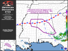
18z HRRR just starting to come in. Box sounding about an hour from now over the boxed area is averaging about 1200 projected DCAPE. Definitely expect some strong straight-line winds in extreme SE AL or S GA this afternoon.