
It’s pretty much a given and established that any sort of LLJ (Nocturnal or SLP based) rapidly increase Low level shear.Not trying to be combative, but what model(s) are you basing this off of? Nothing I have seen shows the LLJ improving conditions, aside from a wind threat.
CAPE looks great across the area, but the lapse rates are poor (and expected to get worse per SPC Meso Analysis) so storms are struggling to take advantage of the CAPE.
Navigation
Install the app
How to install the app on iOS
Follow along with the video below to see how to install our site as a web app on your home screen.
Note: This feature may not be available in some browsers.
More options
-
Welcome to TalkWeather! We see you lurking around TalkWeather! Take the extra step and join us today to view attachments, see less ads and maybe even join the discussion. CLICK TO JOIN TALKWEATHER
You are using an out of date browser. It may not display this or other websites correctly.
You should upgrade or use an alternative browser.
You should upgrade or use an alternative browser.
kcyalater
Member
reed is the hero we need, but not the one we deserve.

Thanksgivingbrown
Member
Now Colbert and Lauderdale are Tor warned
Kds86z
Member
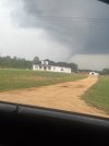
A tornado warning has been issued for the cell just southwest of Mount Pleasant, Tennessee:
View attachment 42759
Chasing @Tennie ?
jiharris0220
Member
Every model across the board both operational and cam shows wind velocities within the LLJ increasing to over 35knots at 7pm.Not trying to be combative, but what model(s) are you basing this off of? Nothing I have seen shows the LLJ improving conditions, aside from a wind threat.
CAPE looks great across the area, but the lapse rates are poor (and expected to get worse per SPC Meso Analysis) so storms are struggling to take advantage of the CAPE.
Helicity values resulting from that will increase at or above 300m^2/s^2 where PBL wind vectors are the least directional to the LLJ.
Any discrete supercell out ahead of the QLCS will then have the greatest chance of producing a significant tornado.
A tornado warning has been issued for the cell just southwest of Mount Pleasant, Tennessee:
View attachment 42759
Right after I posted this, a lightning bolt struck close enough to me that the thunder caused me to nearly jump out of my chair!

- Thread starter
- Moderator
- #350
reed is the hero we need, but not the one we deserve.
I think Brett Adair is trying to get that storm too.
Virtual chasing. I'm sitting at my computer and I have a number of radar programs, livestreams, etc., all going.Chasing @Tennie ?
Shakespeare 2016
Member
I like Reed but he tends to be way out there.
Admittedly, you'd have to be at least a little "out there" in order to do what Reed does.I like Reed but he tends to be way out there.
Justin Hindman
Member
- Messages
- 378
- Reaction score
- 1,165
- Location
- Gardendale Alabama
- Special Affiliations
- SKYWARN® Volunteer
- ARRL Member
That's quite a hook echo west of Florence.

- Moderator
- #356
Gonna go a bit south of me.
kcyalater
Member
reed timmer is tyler owens. tyler owens is reed timmer.I like Reed but he tends to be way out there.
Shakespeare 2016
Member
I tend to believe he also over exaggerates things as well. However, that is Reed for you.Admittedly, you'd have to be at least a little "out there" in order to do what Reed does.
kcyalater
Member
storm is ramping up on a path just south of florence proper. looks to hit muscle shoals head on.