US_Highway15
Member
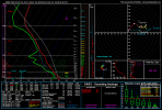
I know I'm going to have people who disagree with me, but I still do not see anything in the recent runs when it comes to SRH and shear (especially at the low level) that suggests there should be an upgrade to MDT, especially when you stack up the kinematics for today against the MDT risk kinematics we saw yesterday and the day before.
If, the SPC does upgrade to MDT, I will more than happy come in here later today and eat crow, but I still firmly believe that there's nothing in the soundings I looked at this morning that suggests an upgrade is necessary.
If, the SPC does upgrade to MDT, I will more than happy come in here later today and eat crow, but I still firmly believe that there's nothing in the soundings I looked at this morning that suggests an upgrade is necessary.