Scottsbluff area tornado warned again, although this time it's radar indicated. Hopefully it stays that way.
Multiple reports of wind driven baseball sized hail, a lot of damage in Scottsbluff.
Follow along with the video below to see how to install our site as a web app on your home screen.
Note: This feature may not be available in some browsers.
Scottsbluff area tornado warned again, although this time it's radar indicated. Hopefully it stays that way.
From one of the earlier Colorado tornadoes...
Holly was the last F/EF3 in the Pueblo CWA.This is some of the most intense looking damage I’ve seen in Colorado. I can’t remember the last time there was anything like this in the state. Maybe Holly back in 2007?
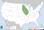
Moving into Sunday, the forecast becomes potentially a bit more
complicated and uncertain. The forecast area will be situated within
a regime of northwest flow aloft in between the departing trough and
building ridge across Texas into the ArkLaTex region. This northwest
flow could usher an MCS into the region, though predictability
regarding the timing and position of any potential complex remains
low. Hi-res CAMs have been supportive of this possibility over the
last several cycles, though placement and timing remains in flux. At
this point, the forecast will indicate gradually increasing PoPs
from the northwest from Sunday morning into Sunday afternoon to
account for this possibility. If any MCS does push into the area,
some severe potential could manifest, particularly if it were to
arrive during the peak heating hours of the afternoon. The high
temperature forecast will also be dependent on convective coverage
with temperatures likely near and above 90 degrees for most if a
drier forecast verifies, or cooler if more widespread convection
affects the area.