joshoctober16
Member

2 areas of rotation north of hasty
Follow along with the video below to see how to install our site as a web app on your home screen.
Note: This feature may not be available in some browsers.
Good catch. It definitely seemed fishy to me at first but I didn’t really think twice of it myself. The fact that the tornado is so far away and still fully condensed despite the fact that tornadoes on this day were not long tracked at all was a big red flag that crossed my mind but I didn’t really think to explore more into.Nope, like I thought after some suspicion, this is a photo that is real that got tweaked to feature a AI tornado in the back. While the RV park in question appears to have been genuinely hit, the tornado in the back is AI generated. This is gonna become a serious issue as AI gets better at generating tornadoes...
Also, it's been confirmed it was actually SLW that caused this at the RV park. But I'm still curious if it was a mix of sorts. 100+ mph SLW can do this absolutely, for sure.
I had a gut feeling it was. AI generates tornadoes in the background awfully blurry and slender like that. Your last point is why. Personal gain, attention and marketing. It looks like a cool, eerie photo because a RV park just got demolished (by SLW BTW) by a supposed tornado in the background. It looks like one of those stellar, once in a lifetime photos. I also know it's AI because these odd AI engagement farming accounts are the only ones to have posted this in particular. It's annoying. And concerning to see.Good catch. It definitely seemed fishy to me at first but I didn’t really think twice of it myself. The fact that the tornado is so far away and still fully condensed despite the fact that tornadoes on this day were not long tracked at all was a big red flag that crossed my mind but I didn’t really think to explore more into.
My question is, what is the point of doing this? Why would people prompt AI to make it? It just doesn’t make any sense. Is there genuine personal gain to be had here?
X checkmarked accounts can make money from interactions. A photo like that will get more engagement and thus earn them more money.My question is, what is the point of doing this? Why would people prompt AI to make it? It just doesn’t make any sense. Is there genuine personal gain to be had here?
I’m not a twitter/X user so I wouldn’t know. Thanks for the clarification. Pretty naive of me to believe that this didn’t have some sort of monetary or engagement bait level motivation to it.X checkmarked accounts can make money from interactions. A photo like that will get more engagement and thus earn them more money.
That was out of left field. Summer time severe having all sorts of surprises.Tornado hatched upgrade from 1630.
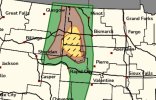
Seems the forecast could almost be a moderate. Hatched wind, hail and tornado all forecasted. (Cig 1-2)Tornado hatched upgrade from 1630.
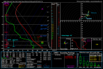
what i pointed out was indeed on the ground2 supercells in eastern canada , both might of had sligth cc drops in the rotation area (iffy for the first one) second one is currently happening going for a town called riverview
Storm 1 (earlier)
View attachment 53924
View attachment 53925
View attachment 53926
Storm 2 (now)
View attachment 53927
View attachment 53928
View attachment 53929