WeathermanLeprechaun
Member
I actually remember seeing some QPF streaks on the Euro s few days ago in this exact area. It was definitely signalling for some prefrontal event
Follow along with the video below to see how to install our site as a web app on your home screen.
Note: This feature may not be available in some browsers.


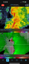
Supercell development?Forecast sounding from Anniston, Alabama off the 00Z RAP, valid at 3 AM CST Saturday morning. Skinny CAPE in this particular location but the wind fields are quite something. Definitely keep those weather radios turned on tonight in Alabama and western Georgia if you live along or south of I-20. I have a feeling that the late-night LLJ will unfortunately work its magic in a few places overnight into the morning.
View attachment 49850
More of a QLCS situation, given a relatively narrow area of instability, but with impressive kinematics come really annoying, still-dangerous and hard-to-predict QLCS tornadoes.Supercell development?


Needs a warning. Tight nowGot my eye on that storm too. Still got rotation (though weak) with it