• Welcome to TalkWeather!
    We see you lurking around TalkWeather! Take the extra step and join us today to view attachments, see less ads and maybe even join the discussion.
    CLICK TO JOIN TALKWEATHER

Severe WX Severe Weather Threat - Jan 2nd - Jan 4th, 2023

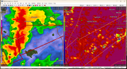
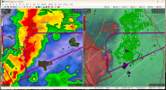
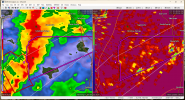
Tornado Watch for parts of AL/GA.
* TORNADO WATCH FOR PORTIONS OF
EASTERN ALABAMA
NORTHERN AND CENTRAL GEORGIA

* EFFECTIVE THIS TUESDAY AFTERNOON AND EVENING FROM 155 PM UNTIL
900 PM EST.

* PRIMARY THREATS INCLUDE...
A FEW TORNADOES LIKELY
SCATTERED DAMAGING WIND GUSTS TO 70 MPH LIKELY
ISOLATED LARGE HAIL EVENTS TO 1 INCH IN DIAMETER POSSIBLE

SUMMARY...CLUSTERS OF THUNDERSTORMS OVER CENTRAL ALABAMA WILL TRACK
EASTWARD ACROSS THE WATCH AREA THIS AFTERNOON AND EARLY EVENING.
SUFFICIENT INSTABILITY AND WINDS ALOFT WILL POSE A RISK OF DAMAGING
WIND GUSTS AND A FEW TORNADOES.
 
New watch has 60/20 tor probs.
 
New TOR east of Maplesville.
 
Not that it means much at this point, but there's a small 90 contour on the SREF's 15z STI.
1672772951129.gif
 
TOR for Autauga Co.
 
Is that SVR south of Alexandria LA worth noting? All isolated by itself.


Sent from my iPhone using Tapatalk
Not much rotation in it at the moment from what I can tell, but it is worth noting if the environment ahead of it is conducive.
 
Squall line rolling through NE AL and NW GA.
1672773887832.png
 
New TOR for Elmore County. Coosa County also has a TOR.

 
New D1 makes no changes aside from trimming the probs out west.
1672774892704.png
 
Circulation heading into Coosa got nasty.
1672775030852.png
 
Back
Top