cincywx
Member

something to watch
Follow along with the video below to see how to install our site as a web app on your home screen.
Note: This feature may not be available in some browsers.
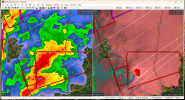
There's a mini supercell factory happening SW of this storm.CC drop at Deatsville?

Deatsville storm now TORR as well.
It's a beast
I guess wave 2 is incoming. Sadly updraft helicity swaths we're more impressive with this wave than the current one now.Not related to current activity but instability is already filling back in northwards behind the rain mass.
View attachment 16462
To my memory squall lines can sometimes look more intimidating on UH than they actually are, though late overnight QLCS-spinups are a real menace.I guess wave 2 is incoming. Sadly updraft helicity swaths we're more impressive with this wave than the current one now.
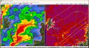
SVR on it now. No tornado possible tag, though.No warning on it currently, but there’s a pretty good circulation approaching the Sylacauga area. It’s not overly tight at the moment, but I’d treat it as if it was a warning if I lived there.

I dont think he is able/allowed to call it a tornado unless and until it is confirmed by the NWS??Most impressive signatures I've seen this entire 2-day event so far.
Spann is great, but he needs to get out of the habit of saying "possible tornado" when there's a clear TDS. That means there's nothing "possible" about it, it's down.
Isi don't think it's forecasting a QCLS I'll check may have changedTo my memory squall lines can sometimes look more intimidating on UH than they actually are, though late overnight QLCS-spinups are a real menace.
Looks like a broken line or line segment almost, hrrr actually has a very strong updraft swath here in the next hour or two just south of Birmingham.Isi don't think it's forecasting a QCLS I'll check may have changed

SPC seems to think best chances for tornadoes for the next few hours will be in that outlined corridor east.Looks like a broken line or line segment almost, hrrr actually has a very strong updraft swath here in the next hour or two just south of Birmingham.
I dont think he is able/allowed to call it a tornado unless and until it is confirmed by the NWS??