
Reminder that Jackson MS Radar is down for upgrades after last weeks delay.
Navigation
Install the app
How to install the app on iOS
Follow along with the video below to see how to install our site as a web app on your home screen.
Note: This feature may not be available in some browsers.
More options
-
Welcome to TalkWeather! We see you lurking around TalkWeather! Take the extra step and join us today to view attachments, see less ads and maybe even join the discussion. CLICK TO JOIN TALKWEATHER
You are using an out of date browser. It may not display this or other websites correctly.
You should upgrade or use an alternative browser.
You should upgrade or use an alternative browser.
Severe WX Severe Weather Threat - February 22-23, 2023 (MO, IL, IN)
- Thread starter Lake Martin EF4
- Start date
- Moderator
- #42
Reminder that Jackson MS Radar is down for upgrades after last weeks delay.
Facepalm.
Yikes, that's not good with models showing the potential for a moderate or high risk type severe event across the area in 5 days.
I hope they reconsider and postpone it.
Last edited:
- Moderator
- #43
Has anyone found a good analog?
This system is more a cut off low, can't be zonal lol. Oof my weather knowledge is getting tested here

tennessee storm chaser
Member
- Messages
- 1,877
- Reaction score
- 4,288
- Location
- jackson tennessee
- Special Affiliations
- SKYWARN® Volunteer
Super Tuesday 2008??? See it mentioned on meso . Slp does take similar track …Has anyone found a good analog?
Last edited:
No sir lol that one is too big in scope compared to this oneSuper Tuesday 2008??? See it mentioned on meso . Slp does take similar track …
tennessee storm chaser
Member
- Messages
- 1,877
- Reaction score
- 4,288
- Location
- jackson tennessee
- Special Affiliations
- SKYWARN® Volunteer
O absolutely agree with u… but there some similarities…. Interesting couple days watching how data plays out. On this oneNo sir lol that one is too big in scope compared to this one
Casuarina Head
Member
This certainly has higher potential than the previous event, simply owing to thermodynamics. However, one caveat: the past seven GFS runs have been slowly trending toward the EC, favouring the main trough instead of the leading impulse. The shortwave gradually becomes less defined over time, while the ridging over the eastern CONUS becomes more amplified. The shortwave is also a bit farther northwest during peak diurnal heating. If this trend continues, the threat of a high-end QLCS, which is otherwise substantial, may decrease. Hopefully this trend will continue, as the thermodynamics alone would support a significant wind-related threat, to not mention the potential for embedded spin-ups. Compared to the last event, this one is certainly one to be watched.
Last edited:
- Moderator
- #49
Facepalm.
Yikes, that's not good with models showing the potential for a moderate or high risk type severe event across the area in 5 days.
I hope they reconsider and postpone it.
NWS Jackson may have to issue an urgent broadcast for storm spotters.
tennessee storm chaser
Member
- Messages
- 1,877
- Reaction score
- 4,288
- Location
- jackson tennessee
- Special Affiliations
- SKYWARN® Volunteer
U nfortunately this range , still models not handling the timing just yet injecting the trough. Hopefully 12 tomorrow start to get better feel of this feature .This certainly has higher potential than the previous event, simply owing to thermodynamics. However, one caveat: the past seven GFS runs have been slowly trending toward the EC, favouring the main trough instead of the leading impulse. The shortwave gradually becomes less defined over time, while the ridging over the eastern CONUS becomes more amplified. The shortwave is also a bit farther northwest during peak diurnal heating. If this trend continues, the threat of a high-end QLCS, which is otherwise substantial, may decrease. Hopefully this trend will continue, as the thermodynamics alone would support a significant wind-related threat, to not mention the potential for embedded spin-ups. Compared to the last event, this one is certainly one to be watched.
- Moderator
- #51
The mean has largely moved towards favoring this event. Let's see if we can continue that through today's runs.
They're never gunna get the maintenance finished with how many times they're postponing hahahNWS Jackson may have to issue an urgent broadcast for storm spotters.
We actually have height falls this go around and the effected region is on the nose of a 500mb Jetstreak. Better than relying on little mesoscale details to provide lift. Overall support of very good lift in the warm sector.This certainly has higher potential than the previous event, simply owing to thermodynamics. However, one caveat: the past seven GFS runs have been slowly trending toward the EC, favouring the main trough instead of the leading impulse. The shortwave gradually becomes less defined over time, while the ridging over the eastern CONUS becomes more amplified. The shortwave is also a bit farther northwest during peak diurnal heating. If this trend continues, the threat of a high-end QLCS, which is otherwise substantial, may decrease. Hopefully this trend will continue, as the thermodynamics alone would support a significant wind-related threat, to not mention the potential for embedded spin-ups. Compared to the last event, this one is certainly one to be watched.
CheeselandSkies
Member
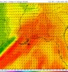
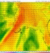
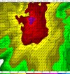
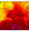
It's interesting, it's another situation where the GFS' area of high CAPE/EHI is a good bit smaller than you would expect it to be based on the size of the area of 60s dewpoints (referring here to FH105 on today's 12Z run), which go as far north as St. Louis and on the southern extent, as wide as western LA to eastern GA. Yet the area of 3KM EHI >1 only goes from central MS to central AL, and as far north as NW-NC TN. Is it forecasting too much cloud cover or warm mid-level temperatures over the rest of those areas?
Meanwhile, those same GFS runs show a huge sleet/ice storm setting up possibly right over me. Good times.
Meanwhile, those same GFS runs show a huge sleet/ice storm setting up possibly right over me. Good times.
Last edited:
Gotta make sure everyone gets in on the "fun."It's interesting, it's another situation where the GFS' area of high CAPE/EHI is a good bit smaller than you would expect it to be based on the size of the area of 60s dewpoints (referring here to FH105 on today's 12Z run), which go as far north as St. Louis and on the southern extent, as wide as western LA to eastern GA. Yet the area of 3KM EHI >1 only goes from central MS to central AL, and as far north as NW-NC TN. Is it forecasting too much cloud cover or warm mid-level temperatures over the rest of those areas?
Meanwhile, those same GFS runs show a huge sleet/ice storm setting up possibly right over me. Good times.
KevinH
Member
Update from trey.
Always the same parts of the south… LA, N/C MS & AL #AlabamaAlley
Well I'm not 100% sure but I think why the main gist of instability being forecasted in a confined location; is in a confined location due to the height falls or lower temperature with atmosphere due to the upper level low swinging through nearby.It's interesting, it's another situation where the GFS' area of high CAPE/EHI is a good bit smaller than you would expect it to be based on the size of the area of 60s dewpoints (referring here to FH105 on today's 12Z run), which go as far north as St. Louis and on the southern extent, as wide as western LA to eastern GA. Yet the area of 3KM EHI >1 only goes from central MS to central AL, and as far north as NW-NC TN. Is it forecasting too much cloud cover or warm mid-level temperatures over the rest of those areas?
Meanwhile, those same GFS runs show a huge sleet/ice storm setting up possibly right over me. Good times.
Theta e values just looking really favor that same area the GFS shows but I doubt instability values are correct a decent jump will likely occur just based off the pretty high theta e values and a pretty strong LLJ..
Looking at the upper air theta e definetly shows in that immediate vicinity very high theta e. Your likely to see some moderate to high instability in the deep south barring any major forecast changes. The sub 1000j instability forecasted is underdone. we saw with the last event around 2500 j with the same or little less in theta e; with a lesser jet.
Attachments
-
 Screenshot_2023-02-18-15-31-06-53_40deb401b9ffe8e1df2f1cc5ba480b12.jpg926.1 KB · Views: 0
 -
 Screenshot_2023-02-18-15-30-43-33_40deb401b9ffe8e1df2f1cc5ba480b12.jpg931.7 KB · Views: 0
 -
 Screenshot_2023-02-18-15-29-34-29_40deb401b9ffe8e1df2f1cc5ba480b12.jpg849.9 KB · Views: 0
 -
 Screenshot_2023-02-18-15-29-13-23_40deb401b9ffe8e1df2f1cc5ba480b12.jpg754 KB · Views: 0
Last edited:
tennessee storm chaser
Member
- Messages
- 1,877
- Reaction score
- 4,288
- Location
- jackson tennessee
- Special Affiliations
- SKYWARN® Volunteer
forecast high for memphis this week pushing 80 in february, that s insane
Good post here I didn't check the LCLs on this event (although usually under 1000 is decent for tornadoes but you'd need better lapse rates than the usual deep south events.) Would be a heck of a wind event. Lol could this end up being a high end severe wind threat for. The deep south usually don't see those here. More in the Midwest.
FFC makes mention of the warm temps coming next week.
.LONG TERM...
(Monday morning through next Friday)
Issued at 1241 PM EST Sat Feb 18 2023
No major changes of note for the long term forecast.
Zonal flow returns to the region as upper ridging slides east.
Several weak midlevel impulses are forecast to pass through the flow
aloft during the first half of the work week. This will result in
low-end PoPs mainly across the TN Valley Region including portions
of North GA. Global ensembles, both GEFS and ECMWF, continue to show
a good bit of variability among members with regards to the
placement of best moisture. Though latest runs of the deterministic
models are starting to highlight the TN Valley Region and in far
North GA as potentially seeing better rain chance for much of the
week. Right now QPF values through next week are forecast to be
light. Did not include the mention of thunder through the course
of the long term given the lack of upper dynamics/forcing.
Biggest thing to highlight for the long term forecast is high
temperatures mid to late week. A warming trend will kick off the
work week with high temperatures Monday forecast to be in the
60s/70s. By late week high temperatures are forecast to climb to
near 80. If these materialize we are looking at temperatures
15-20 degrees above normal!