tennessee storm chaser
Member
On to next Monday for me … all eyes on that systemPutting out a day 3 marginal risk (5% max for any hazard or 2% for tornado) after a Day 5 and Day 4 15% is SPC's equivalent of waving the white flag.
Follow along with the video below to see how to install our site as a web app on your home screen.
Note: This feature currently requires accessing the site using the built-in Safari browser.
On to next Monday for me … all eyes on that systemPutting out a day 3 marginal risk (5% max for any hazard or 2% for tornado) after a Day 5 and Day 4 15% is SPC's equivalent of waving the white flag.
Since this event busted I'll just reticle this for next week.Can we go ahead and add a topic for next week's system?
...DISCUSSION...
Strong west/southwest flow aloft will exist over the CONUS on
Fri/D4, with an upper high over FL and a large-scale upper trough
over the West. High pressure will be centered over the northern
Plains in the wake of an upper wave exiting the Northeast, with a
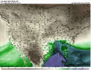
cold front roughly from central TX eastward across the Gulf Coast
states. Subtle height rises will occur across the frontal region as
the FL high retrogrades across the Gulf of Mexico. Scattered showers
and weak thunderstorms may occur in this region, mainly north of the
surface boundary with weak instability and little severe risk.
On Sat/D5, an upper low will move across southern CA, while a wave
amplifies in the northwesterly flow over the northern Plains. This
will reinforce high pressure over the Plains and upper/middle MS
Valley, while the boundary across the Gulf Coast states gradually
makes northward progress with a few showers and weak thunderstorms
within that east-west zone from TX into the Carolinas.
By Sun/D6, models are in relatively good agreement showing the upper
low moving east across the Four Corners states with height falls
into the central and southern Plains by 00Z Mon. Surface
moisture/60s F dewpoints will likely surge northward ahead of the
shortwave trough, with low pressure over the central High Plains
Sun/D6 afternoon, deepening as it pivots into IA during the evening.
MUCAPE around 1000 J/kg appears likely from parts of western KS into
OK, and shear will favor supercells beneath a 50 kt low-level jet.
Initial supercells from the surface low southward along the dryline
will favor large hail and a few tornadoes, with damaging wind threat
extending eastward across KS and OK through evening as storms
possibly become linear. As such, a 15% severe area has been added.
Predictability decreases on Mon/D7 as the upper trough moves toward
the Great Lakes, and a surface boundary trails southwestward into
the lower MS Valley. Here, a plume of mid to upper 60s F dewpoints
will likely remain, beneath 50-60 kt midlevel southwesterlies which
will mean a larger component of the deep-layer shear parallel to the
boundary. Instability will be less by this time owing to relatively
warmer midlevel temperatures, but at least some damaging wind
potential may eventually be noted with storms expected along the
cold front. This front is expected to push offshore by Tue/D8, with
lessening threat of severe storms.
..Jewell.. 02/21/2023
Should a thread be made yet lol? Considering how tomorrow's threat has ended up. Makes me hesitant lolSPC outlined an area for D6 in the Plains.
View attachment 18029
Lol Kevin didn't even tell anybody hahah. @KevinH lol link the thread to the 2023 severe thread next timeAnother thread has already been made for next week. This thread is dedicated to any severe threat today and tomorrow.
Oops my bad.Lol Kevin didn't even tell anybody hahah. @KevinH lol link the thread to the 2023 severe thread next time
Thread 'Severe Weather Threat (NE, OK, TX), Feb 26, 2023' https://talkweather.com/threads/severe-weather-threat-ne-ok-tx-feb-26-2023.2085/
Saw that, pretty strong rotation for a cold core stormDid anyone miss this today?
View attachment 18031
Did anyone miss this today?
Of COURSE you did lolSaw that, pretty strong rotation for a cold core storm
Yesterday, I saw that Feb 22 was dead as doornails. I renamed the thread to encompass the next one (Feb 26) - hence why it's "tail end of February 2023", before you made your thread. Can we get a thread merger arranged (since my renaming to encompass the second late Feb event happened before the KevinH thread)?Oops my bad.
Since this event is over I turned notifications off for it
When I woke up and saw the SPC highlighted next week, I created the new thread.
By the way, you CAN have Talkweather email you every time someone starts a new thread in the “General Discussion” forum lol
Merging multiple events in the same thread is not a good idea mr @Lake Martin EF4.Yesterday, I saw that Feb 22 was dead as doornails. I renamed the thread to encompass the next one (Feb 26) - hence why it's "tail end of February 2023", before you made your thread. Can we get a thread merger arranged (since my renaming to encompass the second late Feb event happened before the KevinH thread)?
YepWow. A day 5 30 percent shade area already over southern plains by SPC….