KevinH
Member
YEP!!!!It makes it a high risk if it's a 30% hatched but not just a regular 30%.

Follow along with the video below to see how to install our site as a web app on your home screen.
Note: This feature may not be available in some browsers.
YEP!!!!It makes it a high risk if it's a 30% hatched but not just a regular 30%.
im right beside you lake, martin lolI'm in that hatched, here we go
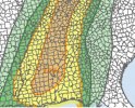
I actually didn't notice the 15% sig moderate. That'll be the highest they go15 percent hatched tornado risk warrants moderate risk
agree also, i can see spc going with 15 hatched laterI actually didn't notice the 15% sig moderate. That'll be the highest they go
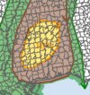
I thought 45% was high risk. And 30% was moderate?
It makes it a high risk if it's a 30% hatched but not just a regular 30%.
Yeah I doubt they'll bump it to a high risk cause I doubt it would be anything other than a hatched area for the higher potential.
Good point, yeah when I usually see a enchanched or slight by day two I always look for the possibility of a upgrade to the next risk level. I'd say about 50% of the time they do a upgrade by day 1.I have never seen a 30% (or 25% back when that was used) tornado contour that didn't have a hatched area within it, although I may have seen one or two where the hatching didn't fill the entire contour (don't ask me when, lol). I suppose it could come up at some point in, say, the case of a landfalling TC that they had high confidence would be a prolific tornado producer since those tend to be less likely to produce strong-violent tornadoes compared to traditional supercell setups, but it would be rare for them to be that confident about it. Even the record-breaking Ivan only warranted an unhatched 15% (MDT risk under the then-current criteria).
Bro lol, I was on those talking points before you hahah I was one of the few going against the grain on this one.Shouted from the rooftops about next two days and nobody believed me. I still think both are going to overperform. The spatial area of sigtor risk is insane and much larger than what's represented with the two 10#s from the SPC.
Today: Dryline in S OK all the way to western TN along the warm front, and potentially (but conditionally) in the WS further south in the arlams area.
Tomorrow: Warm sector from S IN/extreme SW OH all the way down to the gulf coast.
Latest CAMs have the SFC low tracking slightly more north on Thursday which veers the SFC winds slightly, however, the morning convection we're likely to see will probably leave outflow boundaries that will locally enhance hodographs with some SFC backing.

Some strong updraft swaths. Probably have a few long track strong tornadoes tommorowThose north Alabama tracks are about as classic as it gets
Sure hope not. But if a long track tornado were to go across Alabama, it would be on those tracks. It’s amazing how consistent it isSome strong updraft swaths. Probably have a few long track strong tornadoes tommorow
Tommorow is probably one of the better environments for discrete tornadic cells in Alabama in a while ( or atleast from this years January events ) if they can initiate a bit ahead of the cold front, if initiation is stalled to when the front.is super close. It'll turn into a linear mess.Sure hope not. But if a long track tornado were to go across Alabama, it would be on those tracks. It’s amazing how consistent it is
Also I should correct myself, long track supercells. And accompanying strong tornadoes at times. Not necessarily both at the same time lol. Although a possibility remains for thatSure hope not. But if a long track tornado were to go across Alabama, it would be on those tracks. It’s amazing how consistent it is