
cheestaysfly
Member
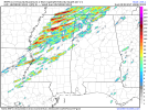
The entire circle is over where I liveNope, go away, right part of the circle is over my house.
Follow along with the video below to see how to install our site as a web app on your home screen.
Note: This feature may not be available in some browsers.
The entire circle is over where I liveNope, go away, right part of the circle is over my house.
Right.Warm moist air from the gulf collides with cold, dry air from the north, along a jet streak that occasionally brings lit matches in the form of low pressure disturbances along for the ride. This is why dixie alley is like no other for severe weather. Location, location, location.

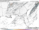
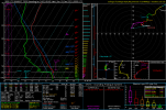
Saturday 18z GFS run maintains a tornado threat in Louisiana but shifts it slightly northwest compared to the previous run. This forecast sounding is from near the LA/AR border - which would of course place it perfectly in the Radar Hole™ between SHV, LZK and DGX:
View attachment 22352
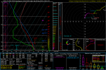
Thanks for the input. Since I'm not an expert at reading these soundings, it's probably a good thing I'm not a professional met - and if I was the NWS would have to change their logo:That hodograph is pretty straight, and the wind barbs pretty unidirectional. That TOR hazard type is likely fueled by quite large CAPE for the time of year. The reason the ceiling isn't expected to be higher with this event is because that's largely not overlapping with strong low-level directional shear.

Well guys, I got an underground tornado shelter installed in my yard in early November so I've got it if needed, but I'm hoping I don't have to test it out just yet. I still feel just as nervous waiting for these days to occur but the shelter does give me a little piece of mind.
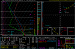
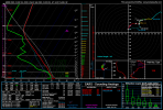
Never heard much about the RRFS, is it reliable?18z RRFS-A. I'm curious if anyone has any soundings from this model?
It's still experimental, but from the times I've used it, it's done pretty good.Never heard much about the RRFS, is it reliable?

.png")
.png")