
Navigation
Install the app
How to install the app on iOS
Follow along with the video below to see how to install our site as a web app on your home screen.
Note: This feature may not be available in some browsers.
More options
-
Welcome to TalkWeather! We see you lurking around TalkWeather! Take the extra step and join us today to view attachments, see less ads and maybe even join the discussion. CLICK TO JOIN TALKWEATHER
You are using an out of date browser. It may not display this or other websites correctly.
You should upgrade or use an alternative browser.
You should upgrade or use an alternative browser.
Severe WX Severe Weather Threat April 7-10, 2021
- Thread starter TH2002
- Start date
Equus
Member
I'm at 65/57 right ahead of that leading line that passed GWX, assuming still in the cold pool from the earlier hailers since that outflow boundary was pretty easy to track all the way into MS. It's weakening so fingers crossed nothing gets too out of control here with the surface relatively stable. Will prolly still stay up and watch it anyway.
- Thread starter
- #143
TH2002
Member
- Messages
- 4,974
- Reaction score
- 11,116
- Location
- California, United States
- Special Affiliations
- SKYWARN® Volunteer
Couplet is tightening now too.The lower of those two independent cells just north of Elkhart TX just showed a velocity couplet on the last scan.
CheeselandSkies
Member
I feel like in a lot of severe events where a predominantly linear mode is expected, the forecast often mentions the possibility of stronger tornadoes from discrete supercells ahead of the line, but it rarely pans out. This is one of the few times I've seen it in this classic a fashion.
It's also very odd how the echo is oriented NW-SE (like an upper Midwest summertime, southeastward-moving northwest flow storm) yet the storm is still moving in the traditional NE direction.
Also interesting that despite a 10% hatched tornado probability zone on the convective outlook, there's not a single red box in effect (all blue). I've seen them routinely issue tornado watches in 5% contours.
Attachments
brianc33710
Member
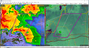
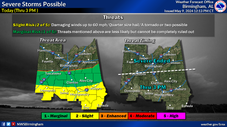
In contrast, BMX has a much larger area of the CWA in the Moderate Risk category than the SPC. Hopefully BMX knows best here, at least with keeping the bad stuff south this time!NWS Birmingham has my location in a marginal risk in the morning; whereas, SPC says enhanced. Pretty big discrepancy!
Last edited:
WhirlingWx
Member
Tornado watch until 7 AM for southern LA/southern MS with 50/30 TOR probs and 70/60 wind probs

Shakespeare 2016
Member
Several tornado warnings out.
- Thread starter
- #148
TH2002
Member
- Messages
- 4,974
- Reaction score
- 11,116
- Location
- California, United States
- Special Affiliations
- SKYWARN® Volunteer
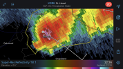
So this fairly discrete supercell near Washington, LA decided to pop up a velocity couplet and prompt a TOR warning out of NOWHERE


Equus
Member
Another vicious couplet near Palmetto, LA, don't see a TDS but could come at any time

Last edited:
Equus
Member
Big time TDS on that just south of Palmetto
- Thread starter
- #153
TH2002
Member
- Messages
- 4,974
- Reaction score
- 11,116
- Location
- California, United States
- Special Affiliations
- SKYWARN® Volunteer
Tornado on the ground near Palmetto

Equus
Member
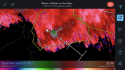
Couplet stronger
EDIT: oof left turn right over Palmetto

EDIT: oof left turn right over Palmetto
- Thread starter
- #155
TH2002
Member
- Messages
- 4,974
- Reaction score
- 11,116
- Location
- California, United States
- Special Affiliations
- SKYWARN® Volunteer
Ouch...

Equus
Member
- Thread starter
- #157
TH2002
Member
- Messages
- 4,974
- Reaction score
- 11,116
- Location
- California, United States
- Special Affiliations
- SKYWARN® Volunteer
Looks like the tornado has finally lifted, let's hope this thing doesn't decide to drop another tornado

- Thread starter
- #158
TH2002
Member
- Messages
- 4,974
- Reaction score
- 11,116
- Location
- California, United States
- Special Affiliations
- SKYWARN® Volunteer
Getting reports of people injured in Palmetto
Bama Ravens
Member
BMX has removed areas north of Birmingham from the risk.
akt1985
Member
Tornado Watch out for southern Alabama and the Florida Panhandle. A stormy morning at the beaches. North of the line, a big blob of heavy rain between the coast and Birmingham.