• Welcome to TalkWeather!
    We see you lurking around TalkWeather! Take the extra step and join us today to view attachments, see less ads and maybe even join the discussion.
    CLICK TO JOIN TALKWEATHER

Severe WX Severe Weather Threat 6/19-6/23/2019

WesL

"Bill, I'm talkin' imminent rueage"
Staff member
Administrator
Moderator
Sustaining Member
Messages
3,344
Reaction score
2,614
Location
Fayetteville, AR
Special Affiliations
  1. SKYWARN® Volunteer
Slept through everything this morning but spotted quite a few large limbs down on the way into work. Sounds like it got gusty.

Edit - Just checked the Perry Williams Memorial Weather Station at the Huntsville Botanical Garden and we had a 48mph gust around 3:30am.

1855

1857
 
Last edited:

Equus

Member
Messages
3,290
Reaction score
3,368
Location
Jasper, AL
Special Affiliations
  1. SKYWARN® Volunteer
Dozed off as it hit... oops. Didnt get as much rain as I hoped. Only damage here seems to be all the corn blown down. It'll straighten back up but it could certainly use more water...
 

Argus

Member
Messages
297
Reaction score
141
Location
Athens, Georgia
Going to start a thread. Looks like we'll be in the MCS northwest flow pattern. From today's SPC Day 1 outlook.

Day 1 Convective Outlook
NWS Storm Prediction Center Norman OK
1252 AM CDT Fri Jun 21 2019

Valid 211200Z - 221200Z

...THERE IS A SLIGHT RISK OF SEVERE THUNDERSTORMS ACROSS PARTS OF
THE CENTRAL AND NORTHERN PLAINS SOUTHEASTWARD INTO THE MID
MISSISSIPPI AND TENNESSEE VALLEYS...

...SUMMARY...
Severe thunderstorms are possible today across parts of the northern
and central Plains, southeastward across the Missouri Valley into
the mid Mississippi and Tennessee Valleys.

...Mid Mississippi Valley/Tennessee Valley/Southeast....
A linear MCS in the lower Missouri Valley this morning is forecast
to move east-southeastward into the mid Mississippi Valley. The line
of strong thunderstorms should turn southeastward into lower Ohio
Valley around midday and may reach the Tennessee Valley this
afternoon. The linear MCS is forecast to track southeastward along a
gradient of moderate instability. This combined with moderate
deep-layer shear and steepening low-level lapse rates may be enough
to maintain an isolated wind-damage threat along the leading edge of
the line. Additional strong to severe convection will be possible
along the outflow boundary that is laid out by the MCS across parts
of the mid Mississippi Valley this afternoon. Isolated marginally
severe thunderstorms with strong wind gusts could occur in parts of
the Southeast along low-level convergence zones that heat up
sufficiently near peak heating.

And also from this morning's FFC discussion.

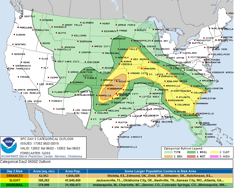
Saturday could be interesting as well as instability is through the
roof with the cold mid levels continuing. We still need the
forcing and flow suggests more of glancing blow for the local
area. That said, we almost always see an outflow ejected southward
that would also provide the needed lift. Have gone mid range pops
for now but could be some areas to realize likely coverage should
shortwave be further SW. Strong to severe activity with any storms
that develop once again. Heat indices for Sat will approach
critical thresholds over the far SE sections and will need to
monitor closely for possible advisory.

Wonder how much instability we're getting.
 
Last edited:
  • Thread starter
  • Moderator
  • #29

Taylor Campbell

Moderator
Moderator
PerryW Project Supporter
Messages
2,102
Reaction score
2,189
Location
Wedowee, AL
Special Affiliations
  1. SKYWARN® Volunteer
Wonder how much instability we're getting.

The most the area has seen all year. Models are showing 3500-5000 joules. 3KM NAM, long range HRRR, RAP, GFS, and EURO are all in very good agreement with an MCS impacting the southern app trail region tomorrow. Point soundings across north Georgia from 15z-18z showed a significantly cold mid levels for this time of the year; minus 11 celsius at 500mb, below freezing in the 600-650mb layer, and a good bit of dry air to work with to 750mb.
 
Last edited:
  • Thread starter
  • Moderator
  • #30

Taylor Campbell

Moderator
Moderator
PerryW Project Supporter
Messages
2,102
Reaction score
2,189
Location
Wedowee, AL
Special Affiliations
  1. SKYWARN® Volunteer
day2.png
 

KoD

Moderator
Staff member
Moderator
PerryW Project Supporter
Messages
1,380
Reaction score
697
Location
Huntsville, AL
SPC has a severe thunderstorm watch out for most of Tennessee, North MS and North AL (& NE Arkansas, less organized).

1859
 
  • Thread starter
  • Moderator
  • #32

Taylor Campbell

Moderator
Moderator
PerryW Project Supporter
Messages
2,102
Reaction score
2,189
Location
Wedowee, AL
Special Affiliations
  1. SKYWARN® Volunteer
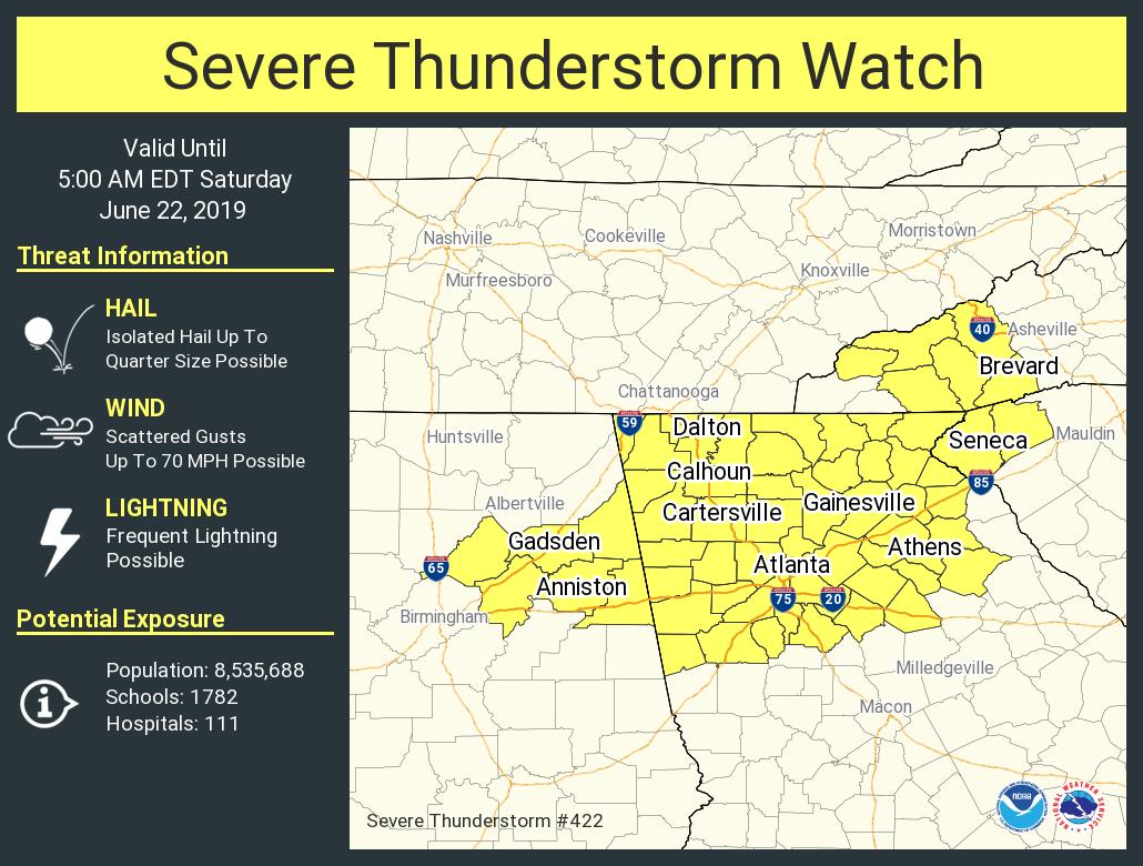
Yep, HRRR, and RAP continue this line south into our extremely unstable atmosphere.
 

Lori

Administrator
Staff member
Administrator
Moderator
Messages
1,035
Reaction score
653
Location
Vandiver, AL
Special Affiliations
  1. SKYWARN® Volunteer
Reports of extensive tree damage outside Nashville...
 

Lori

Administrator
Staff member
Administrator
Moderator
Messages
1,035
Reaction score
653
Location
Vandiver, AL
Special Affiliations
  1. SKYWARN® Volunteer
This mess is coming further south...,
 

Lori

Administrator
Staff member
Administrator
Moderator
Messages
1,035
Reaction score
653
Location
Vandiver, AL
Special Affiliations
  1. SKYWARN® Volunteer
Derecho?
 
Logo 468x120
Back
Top