Argus
Member
So far, "Drusilla" has seemed to miss me. Only clouds right now.
Follow along with the video below to see how to install our site as a web app on your home screen.
Note: This feature may not be available in some browsers.


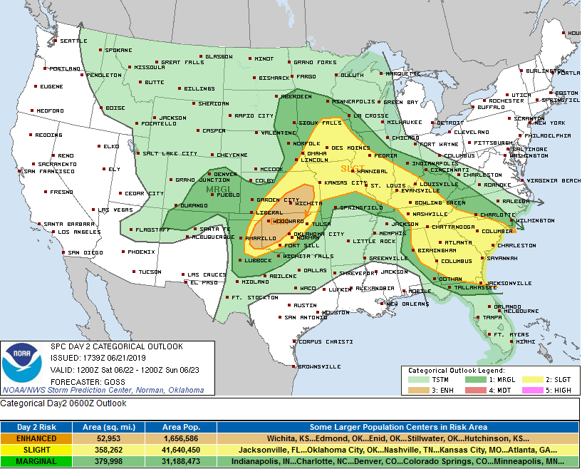
Day 1 Convective Outlook
NWS Storm Prediction Center Norman OK
1252 AM CDT Fri Jun 21 2019
Valid 211200Z - 221200Z
...THERE IS A SLIGHT RISK OF SEVERE THUNDERSTORMS ACROSS PARTS OF
THE CENTRAL AND NORTHERN PLAINS SOUTHEASTWARD INTO THE MID
MISSISSIPPI AND TENNESSEE VALLEYS...
...SUMMARY...
Severe thunderstorms are possible today across parts of the northern
and central Plains, southeastward across the Missouri Valley into
the mid Mississippi and Tennessee Valleys.
...Mid Mississippi Valley/Tennessee Valley/Southeast....
A linear MCS in the lower Missouri Valley this morning is forecast
to move east-southeastward into the mid Mississippi Valley. The line
of strong thunderstorms should turn southeastward into lower Ohio
Valley around midday and may reach the Tennessee Valley this
afternoon. The linear MCS is forecast to track southeastward along a
gradient of moderate instability. This combined with moderate
deep-layer shear and steepening low-level lapse rates may be enough
to maintain an isolated wind-damage threat along the leading edge of
the line. Additional strong to severe convection will be possible
along the outflow boundary that is laid out by the MCS across parts
of the mid Mississippi Valley this afternoon. Isolated marginally
severe thunderstorms with strong wind gusts could occur in parts of
the Southeast along low-level convergence zones that heat up
sufficiently near peak heating.
Saturday could be interesting as well as instability is through the
roof with the cold mid levels continuing. We still need the
forcing and flow suggests more of glancing blow for the local
area. That said, we almost always see an outflow ejected southward
that would also provide the needed lift. Have gone mid range pops
for now but could be some areas to realize likely coverage should
shortwave be further SW. Strong to severe activity with any storms
that develop once again. Heat indices for Sat will approach
critical thresholds over the far SE sections and will need to
monitor closely for possible advisory.
Wonder how much instability we're getting.

It’ll be running into the ridge that covers most of Alabama, though.Yep, HRRR, and RAP continue this line south into our extremely unstable atmosphere.