
Navigation
Install the app
How to install the app on iOS
Follow along with the video below to see how to install our site as a web app on your home screen.
Note: This feature may not be available in some browsers.
More options
-
Welcome to TalkWeather! We see you lurking around TalkWeather! Take the extra step and join us today to view attachments, see less ads and maybe even join the discussion. CLICK TO JOIN TALKWEATHER
You are using an out of date browser. It may not display this or other websites correctly.
You should upgrade or use an alternative browser.
You should upgrade or use an alternative browser.
Severe Weather Threat 5/25-5/26, 2024
- Thread starter MattPetrulli
- Start date
jiharris0220
Member
This thread is now 2nd place behind (Significant tornado events) in total amount of pages.
Beating previous holder (March 30th- April 1st 2023 (South, Southeast, Ohio Valley, Upper Midwest) with 139 pages.
Quite a way of expressing how hyper active this tornado outbreak sequence was.
Beating previous holder (March 30th- April 1st 2023 (South, Southeast, Ohio Valley, Upper Midwest) with 139 pages.
Quite a way of expressing how hyper active this tornado outbreak sequence was.
Gail
Member
I woke up every hour last night until the storms passed through because 2024 weather hasn’t been behaving very well - especially at night. Thankful all we had was a severe thunderstorm warning.
Kds86z
Member
Kds86z
Member
4 Ef3s thus far from this event
CheeselandSkies
Member
May 19th: 403 severe reports
May 20th: 248 severe reports
May 21st: 621 severe reports
May 22nd: 377 severe reports
May 23rd: 515 severe reports
May 24th: 265 severe reports
May 25th: 450 severe reports
May 26th: 1,123 severe reports
Now this is like the May stretches I remember when I was a young weather nerd (2003, '04, '07, '08).
Kds86z
Member
Kds86z
Member
Right?? lol 90s kid hereMay 19th: 403 severe reports
May 20th: 248 severe reports
May 21st: 621 severe reports
May 22nd: 377 severe reports
May 23rd: 515 severe reports
May 24th: 265 severe reports
May 25th: 450 severe reports
May 26th: 1,123 severe reports
Now this is like the May stretches I remember when I was a young weather nerd (2003, '04, '07, '08).
Not to downplay any of the lives lost or property destroyed but I thought SPC was spot on with how they called those events of the 25th and 26th. The moderate outlook with more localized PDS's seemed to be the most appropriate way of communicating threat levels to the media and emergency managers with further dissemination to the public as a whole. I know this community does not have to be as measured as the SPC and there were many calls to raise the outlook to high on the 26th but what eventually transpired lined up with what a moderate outlook could and did produce. The opposite happened on the 26th, with many being pessimistic about SPC raising the outlook to moderate, but again, what ended up transpiring was right in line with what the guidance model of a moderate outlook could and did produce.
My only critique was the flip flopping from moderate the day before to enhanced the day of, only to be increased back to moderate for the 25 and the fairly large changes to the enhanced areas on the 26th. Nobody, especially the general public likes mixed messaging due to it seeming like "They can't make up their minds" "They don't know what they're doing". I am confident this is not the case and is likely a result of the wide flexibility the SPC gives to its forecasters to call things how they think is most appropriate. That said, that leads to two different mind sets, one being that an enhanced can always be upgraded to a moderate, if need be, the other being the ingredients and models have enough agreement that a moderate is appropriate outlook so there is no benefit to waiting to upgrade. Both mind sets have their own pros and cons, but my only concern is public perception as a whole.
I apologize for making you listen to my ramblings, maybe I should start a blog instead, lol.
Last edited:
CheeselandSkies
Member
Not to downplay any of the lives lost or property destroyed but I thought SPC was spot on with how they called those events of the 25th and 26th. The moderate outlook with more localized PDS's seemed to be the most appropriate way of communicating threat levels to the media and emergency managers with further dissemination to the public as a whole. I know this community does not have to be as measured as the SPC and there were many calls to raise the outlook to high on the 26th but what eventually transpired lined up with what a moderate outlook could and did produce. The opposite happened on the 26th, with many being pessimistic about SPC raising the outlook to moderate, but again, what ended up transpiring was right in line with what the guidance model of a moderate outlook could and did produce.
My only critique was the flip flopping from moderate the day before to enhanced the day of, only to be increased back to moderate both days. Nobody, especially the general public likes mixed messaging due to it seeming like "They can't make up their minds" "They don't know what they're doing". I am confident this is not the case and is likely a result of the wide flexibility the SPC gives to its forecasters to call things how they think is most appropriate. That said, that leads to two different mind sets, one being that an enhanced can always be upgraded to a moderate, if need be, the other being the ingredients and models have enough agreement that a moderate is appropriate outlook so there is no benefit to waiting to upgrade. Both mind sets have their own pros and cons, but my only concern is public perception as a whole.
I apologize for making you listen to my ramblings, maybe I should start a blog instead, lol.
That didn't happen...the 26th was enhanced on both Day 2 outlooks, and all the way up until the 20Z Day 1 upgrade to moderate.
The 25th was one of the toughest and most bizarre forecasts I've ever seen. In one outlook cycle, the big uncertainty precluding a high risk went from a cap bust/lack of storm coverage; to excessive storm interactions/outflow. Then when it became apparent the moisture was outperforming the models, it looked like it might go huge (in daylight) after all, only for that left split to come flying through and take out not one, but TWO supercells (the one near Mutual, OK, and the one in south-central Kansas) just as they were on the cusp of producing what would otherwise have almost certainly been long-lived, intense tornadoes.
Tempestas Tonitrua
Member
A few more correctly timed shortwaves and we could’ve had something like May 2003. The plains had so many good synoptic set ups this year.May 19th: 403 severe reports
May 20th: 248 severe reports
May 21st: 621 severe reports
May 22nd: 377 severe reports
May 23rd: 515 severe reports
May 24th: 265 severe reports
May 25th: 450 severe reports
May 26th: 1,123 severe reports
Now this is like the May stretches I remember when I was a young weather nerd (2003, '04, '07, '08).
Thank you for pointing that out. I have edited my post and I fully agree with your thoughts on the 25th.That didn't happen...the 26th was enhanced on both Day 2 outlooks, and all the way up until the 20Z Day 1 upgrade to moderate.
The 25th was one of the toughest and most bizarre forecasts I've ever seen. In one outlook cycle, the big uncertainty precluding a high risk went from a cap bust/lack of storm coverage; to excessive storm interactions/outflow. Then when it became apparent the moisture was outperforming the models, it looked like it might go huge (in daylight) after all, only for that left split to come flying through and take out not one, but TWO supercells (the one near Mutual, OK, and the one in south-central Kansas) just as they were on the cusp of producing what would otherwise have almost certainly been long-lived, intense tornadoes.
Kds86z
Member

5 dead in Kentucky after tornadoes, severe weather. Here's what we know
Severe storms, including two F-1 tornadoes and strong thunderstorms left Louisville and Kentucky with widespread storm damage.
www.courier-journal.com
atrainguy
Member
It’ll be interesting to see in coming years if we are entering a new “traditional” more Plains focused period of time, or if this is just a fluke and winter/early spring Dixie events will take the spotlight again. Way too early to tell, of course, just interesting to ponder.May 19th: 403 severe reports
May 20th: 248 severe reports
May 21st: 621 severe reports
May 22nd: 377 severe reports
May 23rd: 515 severe reports
May 24th: 265 severe reports
May 25th: 450 severe reports
May 26th: 1,123 severe reports
Now this is like the May stretches I remember when I was a young weather nerd (2003, '04, '07, '08).
TH2002
Member
- Messages
- 4,974
- Reaction score
- 11,116
- Location
- California, United States
- Special Affiliations
- SKYWARN® Volunteer
One of the fatalities occurred in Hopkins County, so very likely a result of the tornado...5 dead in Kentucky after tornadoes, severe weather. Here's what we know
Severe storms, including two F-1 tornadoes and strong thunderstorms left Louisville and Kentucky with widespread storm damage.www.courier-journal.com
Also "At least one family who lost their home in the 2021 tornado lost their home again last night"...

The 25th was pretty rough and the SPC got some things wrong in the forecast, but for how chaotic the situation was and how difficult it was to forecast, they did their damn best.Not to downplay any of the lives lost or property destroyed but I thought SPC was spot on with how they called those events of the 25th and 26th. The moderate outlook with more localized PDS's seemed to be the most appropriate way of communicating threat levels to the media and emergency managers with further dissemination to the public as a whole. I know this community does not have to be as measured as the SPC and there were many calls to raise the outlook to high on the 26th but what eventually transpired lined up with what a moderate outlook could and did produce. The opposite happened on the 26th, with many being pessimistic about SPC raising the outlook to moderate, but again, what ended up transpiring was right in line with what the guidance model of a moderate outlook could and did produce.
My only critique was the flip flopping from moderate the day before to enhanced the day of, only to be increased back to moderate for the 25 and the fairly large changes to the enhanced areas on the 26th. Nobody, especially the general public likes mixed messaging due to it seeming like "They can't make up their minds" "They don't know what they're doing". I am confident this is not the case and is likely a result of the wide flexibility the SPC gives to its forecasters to call things how they think is most appropriate. That said, that leads to two different mind sets, one being that an enhanced can always be upgraded to a moderate, if need be, the other being the ingredients and models have enough agreement that a moderate is appropriate outlook so there is no benefit to waiting to upgrade. Both mind sets have their own pros and cons, but my only concern is public perception as a whole.
I apologize for making you listen to my ramblings, maybe I should start a blog instead, lol.
The 26th was absolutely spot on aside from some areas being downgraded too much before the 2000z update; some areas went from MRGL to MDT. Still, they did absolutely phenomenal yesterday.
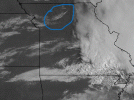
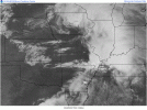
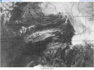
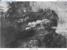
I noticed this yesterday but did not post about it due to how active things got once the storms started to pop and I did not want to get too geeky but I thought it was neat to see the lifting mechanism that interacted with the warm front that initiated the storms.
Attachments
Tanner
Member
As bad as it has been, it could have been so much worse at the same time. May 25th very well could have been even more violent.That didn't happen...the 26th was enhanced on both Day 2 outlooks, and all the way up until the 20Z Day 1 upgrade to moderate.
The 25th was one of the toughest and most bizarre forecasts I've ever seen. In one outlook cycle, the big uncertainty precluding a high risk went from a cap bust/lack of storm coverage; to excessive storm interactions/outflow. Then when it became apparent the moisture was outperforming the models, it looked like it might go huge (in daylight) after all, only for that left split to come flying through and take out not one, but TWO supercells (the one near Mutual, OK, and the one in south-central Kansas) just as they were on the cusp of producing what would otherwise have almost certainly been long-lived, intense tornadoes.