
Navigation
Install the app
How to install the app on iOS
Follow along with the video below to see how to install our site as a web app on your home screen.
Note: This feature may not be available in some browsers.
More options
-
Welcome to TalkWeather! We see you lurking around TalkWeather! Take the extra step and join us today to view attachments, see less ads and maybe even join the discussion. CLICK TO JOIN TALKWEATHER
You are using an out of date browser. It may not display this or other websites correctly.
You should upgrade or use an alternative browser.
You should upgrade or use an alternative browser.
Severe Weather Threat 5/25-5/26, 2024
- Thread starter MattPetrulli
- Start date
Kds86z
Member
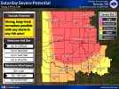
Is that because of SPC, they agree?Jesus, the map from OUN, strong, long track tornadoes possible with ANY storm in the area....
SmokeEater
Member
I mean obviously they do being they're in the same building. But just to see that wording.Is that because of SPC, they agree?
jiharris0220
Member
This is really reminding me of the day before the may 3, 1999 outbreak, because almost the exact problems were present.
The atmosphere had every ingredient present for tornadoes, the forecasters just simply weren’t sure of the magnitude of storm coverage.
Even the new mpas models are wishy washy with its members showing convection. Here’s the link to see for yourself.
The atmosphere had every ingredient present for tornadoes, the forecasters just simply weren’t sure of the magnitude of storm coverage.
Even the new mpas models are wishy washy with its members showing convection. Here’s the link to see for yourself.
CheeselandSkies
Member

Kds86z
Member
Kds86z
Member
What is different then may 6? Didn’t models struggle to show convection, or maybe they did. Been long month .
hurricaneguy
Member
I would agree but not saying this will be anything like that by any means. Forecasters didnt know the true potential until the very early hours of May 3rd. We just have the advantage of seeing the potential setup even earlier now.This is really reminding me of the day before the may 3, 1999 outbreak, because almost the exact problems were present.
The atmosphere had every ingredient present for tornadoes, the forecasters just simply weren’t sure of the magnitude of storm coverage.
Even the new mpas models are wishy washy with its members showing convection. Here’s the link to see for yourself.
slenker
Member
I’m guessing it has to do with the trough being so pronounced with May 6th that caused the CAMs to be so on board with it. This is a more subtle and wider trough with much more zonal flow, that probably has something to do with it.
Casuarina Head
Member
IIRC, similar wording and/or implication was used for 6 May, both in the outlooks and by NWS OUN in its AFD(s). Personally, given the significant uncertainty at play, I would have gone with an enlarged ENH rather than the very broad MDT for tomorrow. The fact that the ML trough is slower to eject on the latest ECMWF might also favour more capping, despite stronger forcing and more favourable shear vectors overall vs. earlier runs.Jesus, the map from OUN, strong, long track tornadoes possible with ANY storm in the area....
Re: CAMs: the thing is, the HRRR has a known tendency to eliminate capping too quickly in late-season setups over the Plains, owing in part to its mixing out of CINH. This is a bias that should probably be taken into account. Given the fact that a) projected high-end events have underperformed and b) marginal events exceeded expectations to date, I would be rather cautious about this D2 outlook, especially about a potential HIGH.
Bottom line: I think there is still a lot of room for yet another unexpected “bust.” Given how synoptically evident this is, CAMs must be seeing something.
Uhh, personally, I think there is no justifiable reason to compare this with such a historic outbreak at this stage. I would think that other setups are more analogous and can be used to make the same comparisons that you do, without indirectly drawing attention to the likelihood of magnitude. Many of these had similar combinations of ingredients and uncertainties at play.This is really reminding me of the day before the may 3, 1999 outbreak
I hope people close businesses and stay home tomorrow, I’d rather have a scenario where we prepare for the worst and nothing happens than having 3-5 violent tornadoes bearing down on people who are clueless until it’s too late.
jiharris0220
Member
There’s every reason to compare, may 3 wasn’t forecasted to be an historic outbreak until it was.IIRC, similar wording and/or implication was used for 6 May, both in the outlooks and by NWS OUN in its AFD(s). Personally, given the significant uncertainty at play, I would have gone with an enlarged ENH rather than the very broad MDT for tomorrow. The fact that the ML trough is slower to eject on the latest ECMWF might also favour more capping, despite stronger forcing and more favourable shear vectors overall vs. earlier runs.
Re: CAMs: the thing is, the HRRR has a known tendency to eliminate capping too quickly in late-season setups over the Plains, owing in part to its mixing out of CINH. This is a bias that should probably be taken into account. Given the fact that a) projected high-end events have underperformed and b) marginal events exceeded expectations to date, I would be rather cautious about this D2 outlook, especially about a potential HIGH.
Bottom line: I think there is still a lot of room for yet another unexpected “bust.” Given how synoptically evident this is, CAMs must be seeing something.
Uhh, personally, I think there is no justifiable reason to compare this with such a historic outbreak at this stage. I would think that other setups are more analogous and can be used to make the same comparisons that you do, without indirectly drawing attention to the likelihood of magnitude. Many of these had similar combinations of ingredients and uncertainties at play.
Tomorrow could surpass that day for all we know, because the potential is there, or nothing could happen at all.
I’m simply comparing from a forecasting perspective, not at all saying that tomorrow will be similar.
I don’t get it. You said there’s a chance of this busting, yet here you are saying theres no reason to compare this to an historic outbreak. We don’t know what’s gonna happen, we can say “bust” or “theres gonna be an EF5.” Regardless, we only know so much of the weather and we’re still learning. With all that being said, we don’t know what will happen tomorrow.IIRC, similar wording and/or implication was used for 6 May, both in the outlooks and by NWS OUN in its AFD(s). Personally, given the significant uncertainty at play, I would have gone with an enlarged ENH rather than the very broad MDT for tomorrow. The fact that the ML trough is slower to eject on the latest ECMWF might also favour more capping, despite stronger forcing and more favourable shear vectors overall vs. earlier runs.
Re: CAMs: the thing is, the HRRR has a known tendency to eliminate capping too quickly in late-season setups over the Plains, owing in part to its mixing out of CINH. This is a bias that should probably be taken into account. Given the fact that a) projected high-end events have underperformed and b) marginal events exceeded expectations to date, I would be rather cautious about this D2 outlook, especially about a potential HIGH.
Bottom line: I think there is still a lot of room for yet another unexpected “bust.” Given how synoptically evident this is, CAMs must be seeing something.
Uhh, personally, I think there is no justifiable reason to compare this with such a historic outbreak at this stage. I would think that other setups are more analogous and can be used to make the same comparisons that you do, without indirectly drawing attention to the likelihood of magnitude. Many of these had similar combinations of ingredients and uncertainties at play.
slenker
Member
Tell that to people on twitter.I hope people close businesses and stay home tomorrow, I’d rather have a scenario where we prepare for the worst and nothing happens than having 3-5 violent tornadoes bearing down on people who are clueless until it’s too late.
cg9450
Member
If this is what happened with the outlook for tomorrow, I wonder what Sunday holds.
Well, I would but, it would be a waste of energy.Tell that to people on twitter.
jiharris0220
Member
This May will certainly go down in history as one of the most active.
warneagle
Member
Yeah I don’t think 5/3/99 is a good analogy here. That was a case where things came together the day of to elevate what looked like a run-of-the-mill May severe weather day in Oklahoma up until that morning. This is…not that.I would agree but not saying this will be anything like that by any means. Forecasters didnt know the true potential until the very early hours of May 3rd. We just have the advantage of seeing the potential setup even earlier now.
Can’t see much reason not to go high on the first outlook tomorrow unless something majorly changes or they really aren’t sure if the cap will break. Very scary setup, not much else to say at this point.
jiharris0220
Member
We have to keep in mind that this was back in 1999, we certainly didn’t have the technology to simply ignore models showing no convection occurring like we can now.Yeah I don’t think 5/3/99 is a good analogy here. That was a case where things came together the day of to elevate what looked like a run-of-the-mill May severe weather day in Oklahoma up until that morning. This is…not that.
Can’t see much reason not to go high on the first outlook tomorrow unless something majorly changes or they really aren’t sure if the cap will break. Very scary setup, not much else to say at this point.