• Welcome to TalkWeather!
    We see you lurking around TalkWeather! Take the extra step and join us today to view attachments, see less ads and maybe even join the discussion.
    CLICK TO JOIN TALKWEATHER
  • April 2024 Weather Video of the Month
    Post your nominations now!
Logo 468x120

Severe Weather Threat 5/25-5/26, 2024

Messages
3,040
Reaction score
5,286
Location
Madison, WI
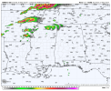
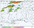
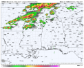
HRRR for tomorrow painting a more QLCS storm mode.

Yep, not impressed with the way that's trended either. As of yesterday was planning to drive down to somewhere in central-southern IL or west-central-southwest IN for a chase. Probably won't at this point; but who knows, it could dramatically uptrend again in the morning.
 

TornadoFan17

Member
Messages
337
Reaction score
671
Location
Olive Branch, Mississippi
Special Affiliations
  1. SKYWARN® Volunteer
Yeah, but the 00z HRRR at hrs 26 thru 28 does have that supercellular look
I do agree for down near us. I was more or less referring to what everyone considered to be the "main threat" for Indiana.

I was just about to comment on the supercellular storm mode in the mid-south.
 

TornadoFan17

Member
Messages
337
Reaction score
671
Location
Olive Branch, Mississippi
Special Affiliations
  1. SKYWARN® Volunteer
Yep, not impressed with the way that's trended either. As of yesterday was planning to drive down to somewhere in central-southern IL or west-central-southwest IN for a chase. Probably won't at this point; but who knows, it could dramatically uptrend again in the morning.
If you want to gamble, you could go into the Arkansas delta and hope one of the supercells painted by the HRRR pans out. Plenty of good sightlines in Eastern Arkansas.
 
Messages
3,040
Reaction score
5,286
Location
Madison, WI
At second look; 00Z HRRR does appear to pop a few supercells in a WNW-ESE oriented band from just south of St. Louis to Evansville, IN (wherever the outflow boundary/effective warm front sets up; expected to be somewhere in that general corridor, is the main focus of that part of the risk area in terms of supercell tornadoes) in the 22-00Z timeframe before they grow upscale.
 

TornadoFan17

Member
Messages
337
Reaction score
671
Location
Olive Branch, Mississippi
Special Affiliations
  1. SKYWARN® Volunteer
I was clamoring for a high risk about a day ago just strictly looking at that crazy HRRR run. But even today, the CAMs were not in agreement at all as to what was going to happen. When there is that much model uncertainty, it really is hard to accurately forecast. I think a 15% hatched was a little overstated in hindsight, but it was justifiable. All the parameters were there, but the lack of a proper lifting mechanism for most areas prevented this event from seeing it's ceiling.

All the CAMs are a great tool, but some of us forget that they are tools to make a forecast. Forecasting is still very much a human job.

This event is still not over technically, but I don't anticipate anything crazy happening in eastern Kansas or western Missouri.
 
Back
Top