Muwx
Member
Way too rural to need a TOREI honestly wouldn't mind a TORE on this. Big CC drop and a nasty velocity couplet.
Follow along with the video below to see how to install our site as a web app on your home screen.
Note: This feature may not be available in some browsers.
Way too rural to need a TOREI honestly wouldn't mind a TORE on this. Big CC drop and a nasty velocity couplet.
Is he streaming or his moderator butting in and doing all the talking? That guy needs the boot in the worst way. He ruins so many streamsReed’s stream right now is unreal!
I've just never understood that reasoning even if NWS uses it. A violent TOR is a violent TOR, whether it hits a big city or it hits nothing.Way too rural to need a TORE

Are they DI's by chance?There are multiple reports of wind turbines being damaged and/or on fire.

BULLETIN - EAS ACTIVATION REQUESTED
Tornado Warning
National Weather Service Des Moines IA
335 PM CDT Tue May 21 2024
The National Weather Service in Des Moines has issued a
* Tornado Warning for...
Northwestern Madison County in south central Iowa...
Southeastern Guthrie County in west central Iowa...
Southwestern Dallas County in central Iowa...
Central Adair County in southwestern Iowa...
* Until 415 PM CDT.
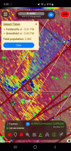
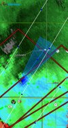
* At 334 PM CDT, a confirmed large and extremely dangerous tornado
was located over Nodaway Park, or 5 miles southwest of Greenfield,
moving northeast at 55 mph.
This is a PARTICULARLY DANGEROUS SITUATION. TAKE COVER NOW!
HAZARD...Damaging tornado.
SOURCE...Weather spotters confirmed tornado.
IMPACT...You are in a life-threatening situation. Flying debris
may be deadly to those caught without shelter. Mobile
homes will be destroyed. Considerable damage to homes,
businesses, and vehicles is likely and complete
destruction is possible.
* The tornado will be near...
Greenfield, Nodaway Park, and Greenfield Municipal Airport around
340 PM CDT.
Stuart around 350 PM CDT.
Dexter and Diamondhead Lake around 355 PM CDT.
Redfield around 400 PM CDT.
Linden around 405 PM CDT.
Other locations impacted by this tornadic thunderstorm include
Redfield, Diamondhead Lake, Fontanelle, Menlo, Linden, Greenfield
Municipal Airport, Nodaway Park, and Dexter.
This includes Interstate 80 between mile markers 85 and 102.
PRECAUTIONARY/PREPAREDNESS ACTIONS...
To repeat, a large, extremely dangerous and potentially deadly
tornado is on the ground. To protect your life, TAKE COVER NOW! Move
to a basement or an interior room on the lowest floor of a sturdy
building. Avoid windows. If you are outdoors, in a mobile home, or in
a vehicle, move to the closest substantial shelter and protect
yourself from flying debris.
&&
LAT...LON 4119 9451 4123 9461 4168 9438 4158 9407
TIME...MOT...LOC 2034Z 214DEG 48KT 4125 9453
TORNADO...OBSERVED
TORNADO DAMAGE THREAT...CONSIDERABLE
MAX HAIL SIZE...1.00 IN