- Moderator
- #1
Looks like an active stretch of severe weather next week. I'm particularly concerned about Tuesday. It has a good chance to get ugly.
Follow along with the video below to see how to install our site as a web app on your home screen.
Note: This feature may not be available in some browsers.


Which 4/26?00z Euro looks pretty alarmingly similar to 4/26 at 500 mb by 00z...
The IA/NE tornado outbreak on 4-26-24Which 4/26?
A lot of people I see on socials are saying that the primary threat on the 21st is going to be from a QLCS with winds and embedded tornadoes…
I think I’d like to know what they’re smoking.


FV3 has a doomsday ef10 tornado scoring up bedrock in Oklahoma.
Can’t wait for this to not happen.
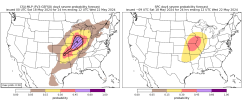
View attachment 27208View attachment 27209
What time will the EF10 hit my houseFV3 has a doomsday ef10 tornado scoring up bedrock in Oklahoma.
Can’t wait for this to not happen.
View attachment 27208View attachment 27209
What time will the EF10 hit my house

L I N K I N B I OWhat time will the EF10 hit my house
L I N K I N B I O
>> For FREE EF10 wedges VISIT scam.link/thisisavirus420 <<
 "It was an EF10, man. It was like, blowing."
H O T H E L I C I T YL I N K I N B I O
>> For FREE EF10 wedges VISIT scam.link/thisisavirus420 <<

Damn, that one crazy lady who wants an EF5 in her backyard would be overly delighted to have an EF10 in her backyard.L I N K I N B I O
>> For FREE EF10 wedges VISIT scam.link/thisisavirus420 <<
Does this include rope, cone, and stovepipe EF10 tornadoes?L I N K I N B I O
>> For FREE EF10 wedges VISIT scam.link/thisisavirus420 <<