
Navigation
Install the app
How to install the app on iOS
Follow along with the video below to see how to install our site as a web app on your home screen.
Note: This feature may not be available in some browsers.
More options
-
Welcome to TalkWeather! We see you lurking around TalkWeather! Take the extra step and join us today to view attachments, see less ads and maybe even join the discussion. CLICK TO JOIN TALKWEATHER
You are using an out of date browser. It may not display this or other websites correctly.
You should upgrade or use an alternative browser.
You should upgrade or use an alternative browser.
Severe WX Severe Weather Threat 4/6-4/7/18
- Thread starter Taylor Campbell
- Start date
Bama Ravens
Member
My temp is falling fast. Down to 53. Going to be a chilly, rainy night. I’ll take it over severe weather.
CheeselandSkies
Member
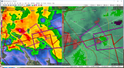
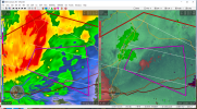
Rather gnarly cluster of supercells now east of Shreveport. The prior tornadic cell's rotation is now embedded in the forward flank precip of the one with the hook southeast of Ninock.
It's interesting to me how some of the cells are oriented about 90 degrees clockwise of typical supercells, with the forward flank V-notch on the south side and the hook/meso on the northwest.
It's interesting to me how some of the cells are oriented about 90 degrees clockwise of typical supercells, with the forward flank V-notch on the south side and the hook/meso on the northwest.
Attachments
Last edited:
Xtreme Weather
Member
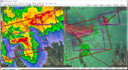
CC drop just now in these two TOR warnings...HP super cells doubt you see this coming if on the ground

Xtreme Weather
Member
Shocked if not on the ground now

CheeselandSkies
Member
champal3003
Member

Xtreme Weather
Member
 Tornado emergency now confirmed violent TOR
CheeselandSkies
Member
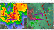
By all indications the tornado of the year so far.
champal3003
Member
Bad situation for Coushatta.
- Moderator
- #31

jmills
Member

Bubba35741
Member
About as strongly worded warning as I can remember.
- Moderator
- #34
Not what you wanna see

SilentShadow87
Member
This is looking flat out violent...would not be at all surprised at an EF4+ rating if it hits anything substantial
jmills
Member
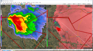
Damage reports coming in via KSLA.
Equus
Member
Wow, that got serious fast. Looks like perhaps more intense west of town but definitely seemed to be on the ground whilst going through.
CheeselandSkies
Member
CheeselandSkies
Member
Equus
Member
Looking as far back as Radarscope will let me on the Texas tornado warned storm SE of Lampasas, WOW. Classic signature of a significant tornado for a while. Headed awfully close to Florence, TX, still with some rotation. I was not expecting significant tornadoes to perhaps be the big story today.