
Navigation
Install the app
How to install the app on iOS
Follow along with the video below to see how to install our site as a web app on your home screen.
Note: This feature may not be available in some browsers.
More options
-
Welcome to TalkWeather! We see you lurking around TalkWeather! Take the extra step and join us today to view attachments, see less ads and maybe even join the discussion. CLICK TO JOIN TALKWEATHER
You are using an out of date browser. It may not display this or other websites correctly.
You should upgrade or use an alternative browser.
You should upgrade or use an alternative browser.
sak
Member
I haven't checked to see whether people are complaining to Spann and others that their homes haven't been destroyed by a tornado today. I'm sure it's coming!
They have started. However, I do think the (social) media overhyped this a bit in the Birmingham area. The threat was never an apocalyptic one for Birmingham. The higher risks were east of I-65 and that appears to still be the best chance of severe weather. Can't totally rule out a severe storm over the western half of the state, but the threat is definitely lower in Tuscaloosa, AL than in Macon, GA.
Even if no more bad weather occurs west of I-65, it will be hard for me to call this a bust. Maybe slightly underperformed... but the models and forecasts have been pretty accurate thus far.
sak
Member
Look, when an EMA Director is reporting confirmed damage, you continue the warning. I couldn't careless if you consider the rotation broad, or jim bob storm chaser doesn't see it. That's just the way it is. In fear of cluttering the thread, this is all I'll say on the matter.
Wasn't he talking about a tornado emergency as opposed to just a warning? I agree with him that FFC is issuing too many tornado emergencies.
X
Xenesthis
Guest
Seriously. People complaining that the perceived "bust" didn't produce tornadoes. God forbid your house doesn't get blown to smithereens!
Kory do you think a line will develop across TN up into KY like some models are showing? It's been sunny all day here and seems like temps and dew points are there
David in SW Blount
Member
Oh yep, it's started. LOL.

Bama Ravens
Member
Dryline must be near the MS/AL state line. Columbus, MS dew point is down to 57.
X
Xenesthis
Guest
Am I the only one that thinks this is a bit premature and disrespectfulOh yep, it's started. LOL.
- Moderator
- #648
Oh yep, it's started. LOL.
Yep, you just can't fix stupid...
- Admin
- #649
- Messages
- 3,618
- Reaction score
- 3,431
- Location
- Fayetteville, AR
- Special Affiliations
- SKYWARN® Volunteer
It would be the same type person that would be screaming they didn't get a warning.Am I the only one that thinks this is a bit premature and disrespectful
Kory
Member
I think we get enough convergence on the dryline we fire off some storms along it in a couple hours.Kory do you think a line will develop across TN up into KY like some models are showing? It's been sunny all day here and seems like temps and dew points are there
sak
Member
The thing is... she might not be wrong. Let's wait and see if this afternoon tornado threat actually materializes across Alabama. I'm not really seeing it. Dewpoints are falling along the MS/AL line and no storms are forming yet.
Equus
Member
75/66 with light SE wind in Jasper apparently, suspect that's not a trend but I do wonder if winds will be more favorable for severe weather before the dryline makes it across the state.
Kory
Member
You can....it's just not socially acceptable.Yep, you just can't fix stupid...
X
Xenesthis
Guest
Anyone know
Where the dry line is? Cause if it's already on the MS/AL line I think it will outrun the window of opportunity
Where the dry line is? Cause if it's already on the MS/AL line I think it will outrun the window of opportunity
Equus
Member
Tornado watch forthcoming N AL thru KY
X
Xenesthis
Guest
Are you certain of thatTornado watch forthcoming N AL thru KY
- Admin
- #657
- Messages
- 3,618
- Reaction score
- 3,431
- Location
- Fayetteville, AR
- Special Affiliations
- SKYWARN® Volunteer
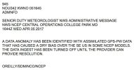
Mesoscale Discussion 0442
NWS Storm Prediction Center Norman OK
0102 PM CDT Wed Apr 05 2017
Areas affected...Portions of central KY...middle
TN...northern/central AL...extreme northwest GA
Concerning...Severe potential...Tornado Watch likely
Valid 051802Z - 052030Z
Probability of Watch Issuance...95 percent
SUMMARY...The risk for significantly severe storms capable of
producing very large hail and tornadoes, along with damaging winds,
is expected to increase around and after 19Z. The issuance of a
Tornado Watch is expected soon.
DISCUSSION...Northward return of modest moisture continues in the
open warm sector of a deep cyclone -- from parts of the TN Valley
region northward to the lower and middle Ohio Valley region. The
leading edge of towering cumulus fields is noted from far northwest
AL into western parts of middle TN and western KY, near a
pre-frontal confluence axis trailing south-southeast of deep low
pressure over eastern MO. Despite the modest moisture, with surface
dewpoints in the 50s to the lower 60s (highest south), moderately
steep midlevel lapse rates around 7.5 C/km will support 500-1500
J/kg of MLCAPE.
Weak capping and strengthening deep ascent ahead of an approaching
midlevel trough will allow convection to gradually increase in the
vicinity of the confluence axis. This activity will mature as it
moves off the confluence axis and into the destabilizing warm
sector -- aided by an appreciable orthogonal component of deep flow
relative to the confluence axis. Strong deep shear and the
aforementioned midlevel lapse rates, encouraging enhanced
storm-scale upward accelerations, will support discrete and
semi-discrete cells capable of very large hail. Also, the
isallobaric response to the deepening surface low to the north will
maintain backed surface winds (pressure falls of 2-4 mb per 2 hours)
across the open warm sector, resulting in long/curved hodographs in
the low levels. Tornadoes are expected, and significant tornadoes
will be possible -- especially as supercells mature within a
corridor from central KY to central/northern AL later this afternoon
into the evening. Damaging wind gusts are also expected.
..Cohen/Hart.. 04/05/2017
ATTN...WFO...MRX...JKL...FFC...LMK...OHX...BMX...HUN...PAH...
LAT...LON 37798383 36768412 34648533 33288695 33278771 34058776
35668756 37428685 38158492 37798383
Bama Ravens
Member
Should be nearing MS/AL state line. Columbus, MS dewpoint is down to 57.Anyone know
Where the dry line is? Cause if it's already on the MS/AL line I think it will outrun the window of opportunity
Equus
Member
PSweather
Member
True, and it's rather messy.You can....it's just not socially acceptable.
Perhaps, however there is a very strong signature with a lot of damage reported.
This thing is off the ground, I'm not really sure why the new TORE was issued. It appeared to be occluding on Baxter's stream.
Sent from my SAMSUNG-SM-G890A using TalkWeather mobile app